
NYKSUND
Cargo
Current Trip
FISHFARMS
| Time Travelled | 18 h, 27 mins |
|---|---|
| Remaining Time | --- |
| Distance Travelled | 185.36 nm |
| Remaining Distance | --- |
| AVG Speed | 11.3 Noeuds |
| MAX Speed | 13.6 Noeuds |
| AVG Wind | 11.4 knots |
| MAX Wind | 22.3 knots |
| MIN Temp | -3.6°C / 25.52°F |
| MAX Temp | 4.7°C / 40.46°F |
| Tirant d eau | 5.8 m |
| Position reçue | 2 m depuis |
Current Position
| Longitude | --- |
|---|---|
| Latitude | --- |
| Etat | Under way using engine |
| Vitesse | 12.7 Noeuds |
| Parcours | 61.5° |
| Zone | Norwegian Sea |
| Station | T-AIS |
| Position reçue | 2 m depuis |
Information
The current position of NYKSUND is in Norwegian Sea with coordinates 64.04694° / 9.78182° as reported on 2025-02-21 06:29 by AIS to our vessel tracker app. The vessel's current speed is 12.7 Noeuds
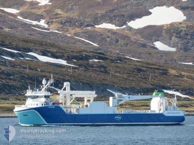
The vessel NYKSUND (IMO: 9803534, MMSI: 257178000) is a Cargo It's sailing under the flag of [NO] Norway.
In this page you can find informations about the vessels current position, last detected port calls, and current voyage information. If the vessels is not in coverage by AIS you will find the latest position.
The current position of NYKSUND is detected by our AIS receivers and we are not responsible for the reliability of the data. The last position was recorded while the vessel was in Coverage by the Ais receivers of our vessel tracking app.
The current draught of NYKSUND as reported by AIS is 5.8 meters
Weather
| Temperature | 2.5°C / 36.5°F |
|---|---|
| Wind Speed | 15 knots |
| Direction | 150° SSE |
| Pressure | 1003 hPa |
| Humidity | 82.7 % |
| Cloud Coverage | 100 % |
Featured Company
Last Port Calls
| Port | Arrival | Departure | Time In Port |
|---|---|---|---|
| 2025-02-20 11:37 | 2025-02-20 12:05 | 27 m | |
| 2025-02-19 12:05 | 2025-02-19 13:32 | 1 h | |
| 2025-02-18 23:30 | 2025-02-19 01:18 | 1 h | |
| 2025-02-17 03:00 | 2025-02-18 15:11 | 1 d | |
| 2025-02-16 05:09 | 2025-02-16 05:26 | 16 m | |
| 2025-02-15 23:33 | 2025-02-15 23:47 | 14 m | |
| 2025-02-15 18:01 | 2025-02-15 18:37 | 35 m | |
| 2025-02-09 07:43 | 2025-02-11 17:28 | 2 d | |
| 2025-02-08 18:52 | 2025-02-08 20:06 | 1 h | |
| 2025-02-08 07:06 | 2025-02-08 09:49 | 2 h |
Last Trips
| Origin | Departure | Destination | Arrival | Distance | |
|---|---|---|---|---|---|
| 2025-02-19 14:32 | 2025-02-20 12:37 | 192.67 nm | |||
| 2025-02-19 02:18 | 2025-02-19 13:05 | 96.24 nm | |||
| 2025-02-18 16:11 | 2025-02-19 00:30 | 92.56 nm | |||
| 2025-02-16 06:26 | 2025-02-17 04:00 | 234.83 nm | |||
| 2025-02-16 00:47 | 2025-02-16 06:09 | 26.43 nm | |||
| 2025-02-15 19:37 | 2025-02-16 00:33 | 60.61 nm | |||
| 2025-02-11 18:28 | 2025-02-15 19:01 | 669.20 nm | |||
| 2025-02-08 21:06 | 2025-02-09 08:43 | 106.32 nm | |||
| 2025-02-08 10:49 | 2025-02-08 19:52 | 95.55 nm | |||
| 2025-02-06 06:05 | 2025-02-08 08:06 | 358.38 nm |
Events
| Heure | Evenement | Détails | Position/ Destination | Info |
|---|---|---|---|---|
| 2025-02-21 03:55 | Démarrage | 8.14 nm, North East of NORDSKAGET |
63.82093 / 8.74250
FISHFARMS
|
Vitesse: 4.4 kn Parcours: 200° |
| 2025-02-21 03:16 | Arret | 8.34 nm, North East of NORDSKAGET |
63.82281 / 8.74908
FISHFARMS
|
Vitesse: Parcours: 264° |
| 2025-02-20 23:49 | Démarrage | 9.64 nm, South East of BREKSTAD |
63.56024 / 9.89415
FISHFARMS
|
Vitesse: 3.5 kn Parcours: 280° |
| 2025-02-20 23:24 | Arret | 9.68 nm, South East of BREKSTAD |
63.56155 / 9.90005
FISHFARMS
|
Vitesse: 0.3 kn Parcours: 80° |
| 2025-02-20 21:06 | Etat Changé | Under way using engine Moored |
63.51804 / 9.14807
FISHFARMS
|
Vitesse: 11.7 kn Parcours: 72.8° |
| 2025-02-20 21:05 | Tirant d'eau modifié | 5.8 5.5 |
63.51506 / 9.13398
FISHFARMS
|
Vitesse: 11.7 kn Parcours: 72.8° |
| 2025-02-20 21:02 | Démarrage | 6.81 nm, South East of FILLAN |
63.51361 / 9.12177
FISHFARMS
|
Vitesse: 8.1 kn Parcours: 80.5° |
| 2025-02-20 21:00 | Changement d'ETA | 2025/02/21 21:00 2025/02/20 21:00 |
63.51486 / 9.11259
FISHFARMS
|
Vitesse: 1.4 kn Parcours: 29° |
| 2025-02-20 20:54 | Changement de destination | FISHFARMS SANDSTAD |
63.51518 / 9.11190
FISHFARMS
|
Vitesse: Parcours: 22° |
| 2025-02-20 19:53 | Etat Changé | Moored Under way using engine |
63.51517 / 9.11194
SANDSTAD
|
Vitesse: Parcours: 22° |