

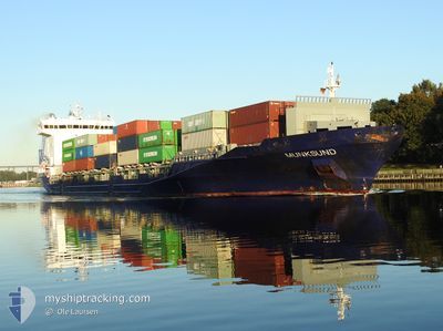
MUNKSUND
Container Ship

Current Trip
| Time Travelled | 10 h, 38 mins |
|---|---|
| Remaining Time | 20 h, 14 mins |
| Distance Travelled | 130.05 nm |
| Remaining Distance | 224.35 nm |
| AVG Speed | 13.5 Noeuds |
| MAX Speed | 15.1 Noeuds |
| AVG Wind | 6.6 knots |
| MAX Wind | 15 knots |
| MIN Temp | 4.5°C / 40.1°F |
| MAX Temp | 8.7°C / 47.66°F |
| Tirant d eau | 7.5 m |
| Position reçue | 1 m depuis |
Current Position
| Longitude | --- |
|---|---|
| Latitude | --- |
| Etat | Under way using engine |
| Vitesse | 11.2 Noeuds |
| Parcours | 257.8° |
| Zone | Baltic Sea |
| Station | T-AIS |
| Position reçue | 1 m depuis |
Information
The current position of MUNKSUND is in Baltic Sea with coordinates 54.77329° / 16.05389° as reported on 2025-03-27 20:05 by AIS to our vessel tracker app. The vessel's current speed is 11.2 Noeuds and is heading at the port of KIEL. The estimated time of arrival as calculated by MyShipTracking vessel tracking app is 2025-03-28 17:21 LT
The vessel MUNKSUND (IMO: 9429223, MMSI: 636020532) is a Container Ship that was built in 2012 ( 13 Age ). It's sailing under the flag of [LR] Liberia.
In this page you can find informations about the vessels current position, last detected port calls, and current voyage information. If the vessels is not in coverage by AIS you will find the latest position.
The current position of MUNKSUND is detected by our AIS receivers and we are not responsible for the reliability of the data. The last position was recorded while the vessel was in Coverage by the Ais receivers of our vessel tracking app.
The current draught of MUNKSUND as reported by AIS is 7.5 meters
Weather
| Temperature | 5.3°C / 41.54°F |
|---|---|
| Wind Speed | 10 knots |
| Direction | 231° SW |
| Pressure | 1017.8 hPa |
| Humidity | 89.6 % |
| Cloud Coverage | 31 % |


Featured Company
Last Port Calls
| Port | Arrival | Departure | Time In Port |
|---|---|---|---|
| 2025-03-26 13:00 | 2025-03-27 10:29 | 21 h | |
| 2025-03-25 06:18 | 2025-03-25 20:57 | 14 h | |
| 2025-03-22 08:20 | 2025-03-23 06:44 | 22 h | |
| 2025-03-21 15:19 | 2025-03-21 23:49 | 8 h | |
| 2025-03-19 22:11 | 2025-03-20 21:15 | 23 h | |
| 2025-03-12 22:05 | 2025-03-14 04:47 | 1 d | |
| 2025-03-11 09:50 | 2025-03-12 04:33 | 18 h | |
| 2025-03-09 08:42 | 2025-03-09 09:40 | 57 m | |
| 2025-03-05 06:07 | 2025-03-07 16:19 | 2 d | |
| 2025-03-03 17:32 | 2025-03-04 07:13 | 13 h |
Most Visited Ports (Last year)
| Port | Arrivals | |
|---|---|---|
| 24 | ||
| 24 | ||
| 18 | ||
| 17 | ||
| 12 | ||
| 10 |
Last Trips
| Origin | Departure | Destination | Arrival | Distance | |
|---|---|---|---|---|---|
| 2025-03-25 20:57 | 2025-03-26 13:00 | 142.62 nm | |||
| 2025-03-23 06:44 | 2025-03-25 06:18 | 496.03 nm | |||
| 2025-03-21 23:49 | 2025-03-22 08:20 | 114.12 nm | |||
| 2025-03-20 21:15 | 2025-03-21 15:19 | 53.20 nm | |||
| 2025-03-14 04:47 | 2025-03-19 22:11 | 1344.88 nm | |||
| 2025-03-12 04:33 | 2025-03-12 22:05 | 118.01 nm | |||
| 2025-03-09 09:40 | 2025-03-11 09:50 | 137.19 nm | |||
| 2025-03-07 16:19 | 2025-03-09 08:42 | 463.42 nm | |||
| 2025-03-04 07:13 | 2025-03-05 06:07 | 311.58 nm | |||
| 2025-03-01 23:08 | 2025-03-03 17:32 | 448.16 nm |
Events
| Heure | Evenement | Détails | Position/ Destination | Info |
|---|---|---|---|---|
| 2025-03-27 19:24 | Changement d'ETA | 2025/03/28 16:00 2025/03/28 09:30 |
54.79526 / 16.27368
KIEL PS
|
Vitesse: 11.2 kn Parcours: 262.1° |
| 2025-03-27 17:33 | Etat Changé | Under way using engine Default |
54.84938 / 16.85522
KIEL PS
|
Vitesse: 10.9 kn Parcours: 255° |
| 2025-03-27 17:33 | Dans la zone couverte |
54.84938 / 16.85522
Baltic Sea
KIEL PS
|
Vitesse: 11 kn Parcours: 254.8° |
|
| 2025-03-27 14:38 | Etat Changé | Default Under way using engine |
54.95782 / 17.73709
KIEL PS
|
Vitesse: 10.5 kn Parcours: 268.7° |
| 2025-03-27 14:24 | Hors de la zone couverte |
54.95874 / 17.80956
Baltic Sea
KIEL PS
|
Vitesse: 10.5 kn Parcours: 268.7° |
|
| 2025-03-27 13:24 | Etat Changé | Under way using engine Default |
54.96066 / 18.19794
KIEL PS
|
Vitesse: 13.8 kn Parcours: 271° |
| 2025-03-27 12:42 | Etat Changé | Default Under way using engine |
54.95701 / 18.47988
KIEL PS
|
Vitesse: 14.1 kn Parcours: 296.1° |
| 2025-03-27 11:41 | Etat Changé | Under way using engine Default |
54.82667 / 18.82851
KIEL PS
|
Vitesse: 14.5 kn Parcours: 308° |
| 2025-03-27 11:32 | Etat Changé | Default Under way using engine |
54.80269 / 18.88078
KIEL PS
|
Vitesse: 14.6 kn Parcours: 307.4° |
| 2025-03-27 09:30 | Changement d'ETA | 2025/03/28 09:30 2025/03/28 09:00 |
54.53566 / 18.56806
KIEL PS
|
Vitesse: 6.3 kn Parcours: 95.2° |