
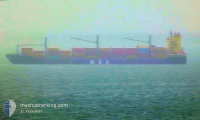
MSC SAMIRA III
Container Ship
Current Trip
| Trip Time | 13 h, 49 mins |
|---|---|
| Trip Distance | 240.39 nm |
| AVG Speed | 16.5 Noeuds |
| MAX Speed | 19.8 Noeuds |
| Tirant d eau | 9.1 m |
| AVG Wind | 12.8 knots |
| MAX Wind | 18.9 knots |
| MIN Temp | 26.2°C / 79.16°F |
| MAX Temp | 28.4°C / 83.12°F |
| Position reçue | 1 m depuis |
Current Position
| Longitude | -97.88621° |
|---|---|
| Latitude | 22.47903° |
| Etat | Under way using engine |
| Vitesse | 2.5 Noeuds |
| Parcours | 345° |
| Zone | Gulf of Mexico |
| Station | T-AIS |
| Position reçue | 1 m depuis |
Info
Information
The current position of MSC SAMIRA III is in Gulf of Mexico with coordinates 22.47903° / -97.88621° as reported on 2024-05-06 07:53 by AIS to our vessel tracker app. The vessel's current speed is 2.5 Noeuds and is currently inside the port of ALTAMIRA.
The vessel MSC SAMIRA III (IMO: 9434462, MMSI: 636020952) is a Container Ship that was built in 2009 ( 15 Age ). It's sailing under the flag of [LR] Liberia.
In this page you can find informations about the vessels current position, last detected port calls, and current voyage information. If the vessels is not in coverage by AIS you will find the latest position.
The current position of MSC SAMIRA III is detected by our AIS receivers and we are not responsible for the reliability of the data. The last position was recorded while the vessel was in Coverage by the Ais receivers of our vessel tracking app.
The current draught of MSC SAMIRA III as reported by AIS is 9.1 meters
Weather
| Temperature | 26.1°C / 78.98°F |
|---|---|
| Wind Speed | 5 knots |
| Direction | 64° ENE |
| Pressure | 1008.7 hPa |
| Humidity | 88.9 % |
| Cloud Coverage | 26 % |
Featured Company
Last Port Calls
| Port | Arrival | Departure | Time In Port |
|---|---|---|---|
| 2024-05-06 07:26 | |||
| 2024-05-04 16:09 | 2024-05-05 17:37 | 1 d | |
| 2024-04-29 05:32 | 2024-05-01 18:50 | 2 d | |
| 2024-04-11 15:28 | 2024-04-12 16:35 | 1 d | |
| 2024-04-07 20:55 | 2024-04-09 15:21 | 1 d | |
| 2024-04-03 15:35 | 2024-04-05 06:23 | 1 d | |
| 2024-03-29 08:35 | 2024-03-30 05:11 | 20 h | |
| 2024-03-21 17:12 | 2024-03-23 06:55 | 1 d | |
| 2024-03-13 15:43 | 2024-03-14 02:01 | 10 h | |
| 2024-03-11 14:49 | 2024-03-12 05:04 | 14 h |
Most Visited Ports (Last year)
| Port | Arrivals | |
|---|---|---|
| 8 | ||
| 5 | ||
| 4 | ||
| 3 | ||
| 3 | ||
| 3 |
Last Trips
| Origin | Departure | Destination | Arrival | Distance | |
|---|---|---|---|---|---|
| 2024-05-05 12:37 | 2024-05-06 02:26 | 240.39 nm | |||
| 2024-05-01 14:50 | 2024-05-04 11:09 | 1147.31 nm | |||
| 2024-04-12 13:35 | 2024-04-29 01:32 | 1955.05 nm | |||
| 2024-04-09 12:51 | 2024-04-11 12:28 | 738.99 nm | |||
| 2024-04-05 02:23 | 2024-04-07 18:25 | 770.00 nm | |||
| 2024-03-30 01:11 | 2024-04-03 11:35 | 1549.87 nm | |||
| 2024-03-23 02:55 | 2024-03-29 04:35 | 1045.18 nm | |||
| 2024-03-13 20:01 | 2024-03-21 13:12 | 1328.98 nm | |||
| 2024-03-11 23:04 | 2024-03-13 09:43 | 255.26 nm | |||
| 2024-03-07 21:21 | 2024-03-11 08:49 | 1198.64 nm |
Events
| Heure | Evenement | Détails | Position/ Destination | Info |
|---|---|---|---|---|
| 2024-05-06 07:26 | Port d'arrivée |
|
22.48719 / -97.85872
[MX] ALTAMIRA
|
Vitesse: 8.2 kn Parcours: 270.4° |
| 2024-05-06 05:45 | Tirant d'eau modifié | 9.1 9.6 |
22.40369 / -97.56079
MXATM
|
Vitesse: 2.7 kn Parcours: 303° |
| 2024-05-06 05:45 | Changement de destination | MXATM BSFPO |
22.40369 / -97.56079
MXATM
|
Vitesse: 2.7 kn Parcours: 303° |
| 2024-05-06 05:45 | Changement d'ETA | 2024/05/06 06:00 2024/04/18 10:00 |
22.40369 / -97.56079
MXATM
|
Vitesse: 2.7 kn Parcours: 303° |
| 2024-05-06 05:08 | Changement de zone | Mexican part of the Gulf of Mexico Bahamas part of the North Atlantic Ocean |
22.35013 / -97.44120
Gulf of Mexico
|
Vitesse: 15.9 kn Parcours: 293.7° |
| 2024-05-06 05:08 | Dans la zone couverte |
22.35013 / -97.44120
Gulf of Mexico
|
Vitesse: 15.9 kn Parcours: 293.7° |
|
| 2024-05-06 05:06 | Etat Changé | Under way using engine Default |
22.34679 / -97.43299
BSFPO
|
Vitesse: 16 kn Parcours: 330° |
| 2024-05-05 17:37 | PORT DE DEPART |
|
19.20167 / -96.11334
BSFPO
|
Vitesse: 6.9 kn Parcours: 105° |
| 2024-05-05 17:31 | Démarrage |
19.20415 / -96.12825
[MX] VERACRUZ
|
Vitesse: 6.9 kn Parcours: 105° |
|
| 2024-05-04 16:52 | Arret |
19.21092 / -96.13879
[MX] VERACRUZ
|
Vitesse: Parcours: 238° |