
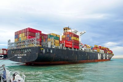
MSC CHARLESTON
Container Ship
Current Trip
| Time Travelled | 10 days |
|---|---|
| Remaining Time | --- |
| Distance Travelled | 3387.72 nm |
| Remaining Distance | 18.37 nm |
| AVG Speed | 16.7 Noeuds |
| MAX Speed | 18.8 Noeuds |
| AVG Wind | 9.3 knots |
| MAX Wind | 18 knots |
| MIN Temp | 24.7°C / 76.46°F |
| MAX Temp | 28.6°C / 83.48°F |
| Tirant d eau | 14.8 m |
| Position reçue | 9 d depuis |
Current Position
| Longitude | --- |
|---|---|
| Latitude | --- |
| Etat | Under way using engine |
| Vitesse | 17.2 Noeuds |
| Parcours | 314.1° |
| Zone | Malacca Strait |
| Station | T-AIS |
| Position reçue | 9 d depuis |
Info
Information
The current position of MSC CHARLESTON is in Malacca Strait with coordinates 3.96329° / 99.79724° as reported on 2025-11-30 19:06 by AIS to our vessel tracker app. The vessel's current speed is 17.2 Noeuds and is heading at the port of PORT LOUIS. The estimated time of arrival as calculated by MyShipTracking vessel tracking app is 2025-12-08 03:00 LT
The vessel MSC CHARLESTON (IMO: 9299537, MMSI: 255806367) is a Container Ship that was built in 2006 ( 19 Age ). It's sailing under the flag of [PT] Portugal.
In this page you can find informations about the vessels current position, last detected port calls, and current voyage information. If the vessels is not in coverage by AIS you will find the latest position.
The current position of MSC CHARLESTON is detected by our AIS receivers and we are not responsible for the reliability of the data. The last position was recorded while the vessel was in Coverage by the Ais receivers of our vessel tracking app.
The current draught of MSC CHARLESTON as reported by AIS is 14.8 meters
Weather
| Temperature | 26.1°C / 78.98°F |
|---|---|
| Wind Speed | 11 knots |
| Direction | 84° E |
| Pressure | 1014.1 hPa |
| Humidity | 73.4 % |
| Cloud Coverage | 11 % |
Featured Company
Last Port Calls
Last Trips
| Origin | Departure | Destination | Arrival | Distance | |
|---|---|---|---|---|---|
| 2025-11-08 07:04 | 2025-11-29 07:32 | 3801.74 nm | |||
| 2025-10-28 12:33 | 2025-11-07 13:52 | 2611.06 nm | |||
| 2025-10-25 22:52 | 2025-10-26 17:08 | 13.62 nm | |||
| 2025-10-19 16:02 | 2025-10-25 07:59 | 1485.27 nm | |||
| 2025-09-21 19:43 | 2025-10-18 10:58 | 11349.78 nm |
Events
| Heure | Evenement | Détails | Position/ Destination | Info |
|---|---|---|---|---|
| 2025-12-10 00:36 | Démarrage | 20.95 nm, West of PORT LOUIS |
-20.04592 / 57.12534
MUPLU
|
Vitesse: 5.2 kn Parcours: 217° |
| 2025-12-09 02:40 | Arret | 18.27 nm, North West of PORT LOUIS |
-19.89029 / 57.29715
MUPLU
|
Vitesse: 0.1 kn Parcours: 70° |
| 2025-12-09 00:36 | Démarrage | 19.83 nm, West of PORT LOUIS |
-20.06105 / 57.14155
MUPLU
|
Vitesse: 6.3 kn Parcours: 23° |
| 2025-12-08 04:20 | Arret | 17.29 nm, North West of PORT LOUIS |
-19.93749 / 57.26474
MUPLU
|
Vitesse: 0.2 kn Parcours: 50° |
| 2025-11-30 19:13 | Etat Changé | Default Under way using engine |
3.98753 / 99.77192
MUPLU
|
Vitesse: 17.2 kn Parcours: 314.1° |
| 2025-11-30 19:06 | Hors de la zone couverte |
3.96329 / 99.79724
Malacca Strait
MUPLU
|
Vitesse: 17.2 kn Parcours: 314.1° |
|
| 2025-11-30 18:57 | Etat Changé | Under way using engine Default |
3.93398 / 99.82780
MUPLU
|
Vitesse: 17.3 kn Parcours: 314° |
| 2025-11-30 18:45 | Etat Changé | Default Under way using engine |
3.89376 / 99.86975
MUPLU
|
Vitesse: 17.2 kn Parcours: 313.9° |
| 2025-11-30 18:35 | Etat Changé | Under way using engine Default |
3.86070 / 99.90428
MUPLU
|
Vitesse: 17 kn Parcours: 315° |
| 2025-11-30 18:21 | Dans la zone couverte |
3.86070 / 99.90428
Malacca Strait
MUPLU
|
Vitesse: 17.1 kn Parcours: 314.1° |