
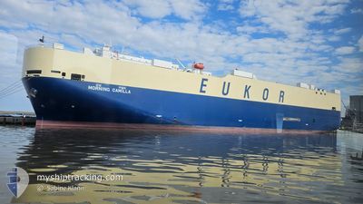
MORNING CAMILLA
Vehicles Carrier
Current Trip
| Trip Time | 19 days |
|---|---|
| Trip Distance | 7829.74 nm |
| AVG Speed | 16.8 Noeuds |
| MAX Speed | 18.9 Noeuds |
| Tirant d eau | 8.6 m |
| AVG Wind | 13.8 knots |
| MAX Wind | 30 knots |
| MIN Temp | 10.5°C / 50.9°F |
| MAX Temp | 28.1°C / 82.58°F |
| Position reçue | 3 h, 55 m depuis |
Current Position
| Longitude | --- |
|---|---|
| Latitude | --- |
| Etat | Moored |
| Vitesse | |
| Parcours | 42° |
| Zone | North Pacific Ocean |
| Station | T-AIS |
| Position reçue | 3 h, 55 m depuis |
Info
Information
The current position of MORNING CAMILLA is in North Pacific Ocean with coordinates 8.95148° / -79.56590° as reported on 2024-11-28 19:39 by AIS to our vessel tracker app. The vessel's current speed is 0 Noeuds and is currently inside the port of BALBOA.
The vessel MORNING CAMILLA (IMO: 9477919, MMSI: 440104000) is a Vehicles Carrier that was built in 2009 ( 15 Age ). It's sailing under the flag of [KR] Korea.
In this page you can find informations about the vessels current position, last detected port calls, and current voyage information. If the vessels is not in coverage by AIS you will find the latest position.
The current position of MORNING CAMILLA is detected by our AIS receivers and we are not responsible for the reliability of the data. The last position was recorded while the vessel was in Coverage by the Ais receivers of our vessel tracking app.
The current draught of MORNING CAMILLA as reported by AIS is 8.6 meters
Weather
| Temperature | 25.2°C / 77.36°F |
|---|---|
| Wind Speed | 5 knots |
| Direction | 173° S |
| Pressure | 1008.5 hPa |
| Humidity | 90.1 % |
| Cloud Coverage | 48 % |
Featured Company
Last Port Calls
| Port | Arrival | Departure | Time In Port |
|---|---|---|---|
| 2024-11-28 19:02 | |||
| 2024-11-08 21:30 | 2024-11-09 08:30 | 10 h | |
| 2024-11-08 00:37 | 2024-11-08 07:37 | 7 h | |
| 2024-11-06 21:57 | 2024-11-07 08:22 | 10 h | |
| 2024-10-31 22:12 | 2024-11-01 04:06 | 5 h | |
| 2024-10-30 06:24 | 2024-10-31 12:56 | 1 d | |
| 2024-10-25 22:43 | 2024-10-26 07:13 | 8 h | |
| 2024-10-25 02:04 | 2024-10-25 08:30 | 6 h | |
| 2024-10-22 07:26 | 2024-10-22 19:14 | 11 h | |
| 2024-09-13 02:06 | 2024-09-13 23:25 | 21 h |
Last Trips
| Origin | Departure | Destination | Arrival | Distance | |
|---|---|---|---|---|---|
| 2024-11-09 17:30 | 2024-11-28 14:02 | 7829.74 nm | |||
| 2024-11-08 16:37 | 2024-11-09 06:30 | 209.58 nm | |||
| 2024-11-07 17:22 | 2024-11-08 09:37 | 247.71 nm | |||
| 2024-11-01 13:06 | 2024-11-07 06:57 | 1316.10 nm | |||
| 2024-10-31 21:56 | 2024-11-01 07:12 | 127.78 nm | |||
| 2024-10-26 16:13 | 2024-10-30 15:24 | 1185.82 nm | |||
| 2024-10-25 17:30 | 2024-10-26 07:43 | 201.08 nm | |||
| 2024-10-23 03:14 | 2024-10-25 11:04 | 918.26 nm | |||
| 2024-09-14 00:25 | 2024-10-22 15:26 | 14352.85 nm | |||
| 2024-09-12 01:45 | 2024-09-13 03:06 | 256.05 nm |
Events
| Heure | Evenement | Détails | Position/ Destination | Info |
|---|---|---|---|---|
| 2024-11-28 19:46 | Etat Changé | Default Moored |
8.95148 / -79.56588
[PA] BALBOA
|
Vitesse: Parcours: 42° |
| 2024-11-28 19:39 | Etat Changé | Moored Default |
8.95148 / -79.56590
[PA] BALBOA
|
Vitesse: Parcours: 42° |
| 2024-11-28 19:39 | Hors de la zone couverte |
8.95148 / -79.56590
North Pacific Ocean
[PA] BALBOA
|
Vitesse: Parcours: 206° |
|
| 2024-11-28 19:30 | Etat Changé | Default Under way using engine |
8.95148 / -79.56592
[PA] BALBOA
|
Vitesse: Parcours: 42° |
| 2024-11-28 19:15 | Arret |
8.95145 / -79.56593
[PA] BALBOA
|
Vitesse: 0.2 kn Parcours: 45° |
|
| 2024-11-28 19:03 | Etat Changé | Under way using engine Default |
8.94862 / -79.56788
[PA] BALBOA
|
Vitesse: 1.8 kn Parcours: 346° |
| 2024-11-28 19:02 | Etat Changé | Default Under way using engine |
8.94832 / -79.56786
[PA] BALBOA
|
Vitesse: 5.4 kn Parcours: 321° |
| 2024-11-28 19:02 | Port d'arrivée |
|
8.94832 / -79.56786
[PA] BALBOA
|
Vitesse: 5.4 kn Parcours: 321° |
| 2024-11-28 17:59 | Démarrage | 3.67 nm, North East of TABOGUILLA |
8.86433 / -79.49525
PA BLB
|
Vitesse: 3.1 kn Parcours: 304° |
| 2024-11-28 17:40 | Etat Changé | Under way using engine Default |
8.86153 / -79.49262
PA BLB
|
Vitesse: 0.4 kn Parcours: 345° |