
MISONDA
Cargo
Current Trip
Current Position
| Longitude | --- |
|---|---|
| Latitude | --- |
| Etat | SART - Nav Aid - MOB |
| Vitesse | |
| Parcours | --- |
| Zone | North Sea |
| Station | T-AIS |
| Position reçue | Maintenant |
Info
Information
The current position of MISONDA is in North Sea with coordinates 51.25476° / 4.41387° as reported on 2024-11-27 05:05 by AIS to our vessel tracker app. The vessel's current speed is 0 Noeuds and is currently inside the port of ANTWERP.
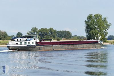
The vessel MISONDA (IMO: 244660584, MMSI: 244660584) is a Cargo It's sailing under the flag of [NL] Netherlands.
In this page you can find informations about the vessels current position, last detected port calls, and current voyage information. If the vessels is not in coverage by AIS you will find the latest position.
The current position of MISONDA is detected by our AIS receivers and we are not responsible for the reliability of the data. The last position was recorded while the vessel was in Coverage by the Ais receivers of our vessel tracking app.
The current draught of MISONDA as reported by AIS is 2.6 meters
Weather
| Temperature | 7.1°C / 44.78°F |
|---|---|
| Wind Speed | 6 knots |
| Direction | 136° SE |
| Pressure | 1016.8 hPa |
| Humidity | 91.7 % |
| Cloud Coverage | 100 % |
Featured Company
Last Port Calls
| Port | Arrival | Departure | Time In Port |
|---|---|---|---|
| 2024-11-07 11:00 | |||
| 2024-11-07 08:26 | 2024-11-07 10:53 | 2 h | |
| 2024-11-07 06:53 | 2024-11-07 08:14 | 1 h | |
| 2024-11-05 12:22 | 2024-11-05 18:09 | 5 h | |
| 2024-11-04 11:16 | 2024-11-04 13:01 | 1 h | |
| 2024-11-01 12:41 | 2024-11-04 10:50 | 2 d | |
| 2024-11-01 11:06 | 2024-11-01 12:33 | 1 h | |
| 2024-10-31 08:12 | 2024-10-31 11:35 | 3 h | |
| 2024-10-28 06:57 | 2024-10-28 09:47 | 2 h | |
| 2024-10-25 12:40 | 2024-10-28 06:52 | 2 d |
Last Trips
| Origin | Departure | Destination | Arrival | Distance | |
|---|---|---|---|---|---|
| 2024-11-07 11:53 | 2024-11-07 12:00 | 0.86 nm | |||
| 2024-11-07 09:14 | 2024-11-07 09:26 | 0.79 nm | |||
| 2024-11-05 19:09 | 2024-11-07 07:53 | 110.11 nm | |||
| 2024-11-04 14:01 | 2024-11-05 13:22 | 102.03 nm | |||
| 2024-11-04 11:50 | 2024-11-04 12:16 | 1.40 nm | |||
| 2024-11-01 13:33 | 2024-11-01 13:41 | 0.84 nm | |||
| 2024-10-31 12:35 | 2024-11-01 12:06 | 111.61 nm | |||
| 2024-10-28 10:47 | 2024-10-31 09:12 | 119.38 nm | |||
| 2024-10-28 07:52 | 2024-10-28 07:57 | 0.49 nm | |||
| 2024-10-25 14:17 | 2024-10-25 14:40 | 0.78 nm |
Events
| Heure | Evenement | Détails | Position/ Destination | Info |
|---|---|---|---|---|
| 2024-11-26 09:19 | Dans la zone couverte |
51.25478 / 4.41381
North Sea
[BE] ANTWERP
|
Vitesse: Parcours: 7.4° |
|
| 2024-11-23 23:19 | Hors de la zone couverte |
51.25476 / 4.41386
North Sea
[BE] ANTWERP
|
Vitesse: Parcours: 348.3° |
|
| 2024-11-22 12:18 | Dans la zone couverte |
51.25474 / 4.41394
North Sea
[BE] ANTWERP
|
Vitesse: Parcours: 286.5° |
|
| 2024-11-22 11:20 | Hors de la zone couverte |
51.25476 / 4.41383
North Sea
[BE] ANTWERP
|
Vitesse: Parcours: 63.6° |