
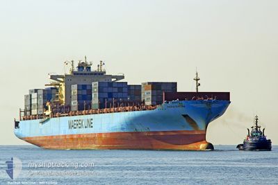
MAERSK SENTOSA
Container Ship
Current Trip
| Time Travelled | 9 days |
|---|---|
| Remaining Time | --- |
| Distance Travelled | 3880.58 nm |
| Remaining Distance | --- |
| AVG Speed | 17.8 Noeuds |
| MAX Speed | 20.7 Noeuds |
| AVG Wind | 8.5 knots |
| MAX Wind | 17.6 knots |
| MIN Temp | 17.2°C / 62.96°F |
| MAX Temp | 29°C / 84.2°F |
| Tirant d eau | 14.6 m |
| Position reçue | 1 d depuis |
Current Position
| Longitude | --- |
|---|---|
| Latitude | --- |
| Etat | Under way using engine |
| Vitesse | 19.3 Noeuds |
| Parcours | 219.8° |
| Zone | Indian Ocean |
| Station | T-AIS |
| Position reçue | 1 d depuis |
Info
Information
The current position of MAERSK SENTOSA is in Indian Ocean with coordinates -30.33479° / 31.42069° as reported on 2025-02-15 16:21 by AIS to our vessel tracker app. The vessel's current speed is 19.3 Noeuds and is heading at the port of TANGER MED. The estimated time of arrival as calculated by MyShipTracking vessel tracking app is 2025-03-01 23:00 LT
The vessel MAERSK SENTOSA (IMO: 9315202, MMSI: 369246000) is a Container Ship that was built in 2007 ( 18 Age ). It's sailing under the flag of [US] USA.
In this page you can find informations about the vessels current position, last detected port calls, and current voyage information. If the vessels is not in coverage by AIS you will find the latest position.
The current position of MAERSK SENTOSA is detected by our AIS receivers and we are not responsible for the reliability of the data. The last position was recorded while the vessel was in Coverage by the Ais receivers of our vessel tracking app.
The current draught of MAERSK SENTOSA as reported by AIS is 14.6 meters
Weather
| Temperature | 21.3°C / 70.34°F |
|---|---|
| Wind Speed | 2 knots |
| Direction | 98° E |
| Pressure | 1015.5 hPa |
| Humidity | 76.2 % |
| Cloud Coverage | 14 % |
Featured Company
Last Port Calls
| Port | Arrival | Departure | Time In Port |
|---|---|---|---|
| 2025-02-05 23:02 | 2025-02-07 01:02 | 1 d | |
| 2025-02-01 03:28 | 2025-02-02 02:13 | 22 h | |
| 2025-01-30 22:18 | 2025-01-31 09:33 | 11 h | |
| 2025-01-28 03:26 | 2025-01-29 07:07 | 1 d | |
| 2025-01-25 06:39 | 2025-01-26 03:35 | 20 h | |
| 2025-01-22 07:54 | |||
| 2024-12-20 09:02 | 2024-12-21 07:54 | 22 h | |
| 2024-12-18 14:21 | 2024-12-19 02:54 | 12 h | |
| 2024-12-12 15:48 | 2024-12-14 13:41 | 1 d | |
| 2024-12-07 13:38 | 2024-12-09 02:01 | 1 d |
Most Visited Ports (Last year)
| Port | Arrivals | |
|---|---|---|
| 9 | ||
| 6 | ||
| 6 | ||
| 5 | ||
| 5 | ||
| 5 |
Last Trips
| Origin | Departure | Destination | Arrival | Distance | |
|---|---|---|---|---|---|
| 2025-02-02 07:43 | 2025-02-06 03:02 | 1091.33 nm | |||
| 2025-01-31 15:03 | 2025-02-01 08:58 | 250.34 nm | |||
| 2025-01-29 12:07 | 2025-01-31 03:48 | 474.31 nm | |||
| 2025-01-26 07:35 | 2025-01-28 08:26 | 848.85 nm | |||
| 2024-12-21 02:54 | 2025-01-22 11:54 | 12933.86 nm | |||
| 2024-12-18 21:54 | 2024-12-20 04:02 | 312.51 nm | |||
| 2024-12-14 07:41 | 2024-12-18 09:21 | 1735.49 nm | |||
| 2024-12-08 21:01 | 2024-12-12 09:48 | 1349.50 nm | |||
| 2024-12-06 19:49 | 2024-12-07 08:38 | 115.84 nm | |||
| 2024-12-04 03:52 | 2024-12-06 03:55 | 641.50 nm |
Events
| Heure | Evenement | Détails | Position/ Destination | Info |
|---|---|---|---|---|
| 2025-02-15 16:27 | Etat Changé | Default Under way using engine |
-30.35735 / 31.39910
MAPTM
|
Vitesse: 19.3 kn Parcours: 219.8° |
| 2025-02-15 16:21 | Hors de la zone couverte |
-30.33479 / 31.42069
Indian Ocean
MAPTM
|
Vitesse: 19.3 kn Parcours: 219.8° |
|
| 2025-02-15 14:21 | Tirant d'eau modifié | 14.6 12.8 |
-29.83853 / 31.89372
MAPTM
|
Vitesse: 19 kn Parcours: 220.5° |
| 2025-02-15 14:21 | Changement de destination | MAPTM PQ 1 |
-29.83853 / 31.89372
MAPTM
|
Vitesse: 19 kn Parcours: 220.5° |
| 2025-02-15 14:21 | Changement d'ETA | 2025/03/01 23:00 2025/01/28 01:00 |
-29.83853 / 31.89372
MAPTM
|
Vitesse: 19 kn Parcours: 220.5° |
| 2025-02-15 14:19 | Changement de zone | South African part of the Indian Ocean Omani part of the Gulf of Oman |
-29.83039 / 31.90162
Indian Ocean
|
Vitesse: 19.1 kn Parcours: 220.9° |
| 2025-02-15 14:18 | Etat Changé | Under way using engine Default |
-29.82798 / 31.90402
PQ 1
|
Vitesse: 19.2 kn Parcours: 220° |
| 2025-02-15 14:07 | Dans la zone couverte |
-29.83039 / 31.90162
Indian Ocean
|
Vitesse: 19.1 kn Parcours: 220.9° |
|
| 2025-02-13 10:31 | Démarrage |
-16.42673 / 40.63847
PQ 1
|
Vitesse: 15.2 kn Parcours: 189° |
|
| 2025-02-13 09:19 | Arret |
-16.38716 / 40.62507
PQ 1
|
Vitesse: 0.3 kn Parcours: 39° |