
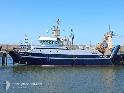
LOUWE SENIOR
Trawler
Current Trip
| Trip Time | 3 days |
|---|---|
| Trip Distance | 469.58 nm |
| AVG Speed | 6.8 Noeuds |
| MAX Speed | 12 Noeuds |
| Tirant d eau | 5.4 m |
| AVG Wind | 18.4 knots |
| MAX Wind | 31 knots |
| MIN Temp | 4.7°C / 40.46°F |
| MAX Temp | 10.3°C / 50.54°F |
| Position reçue | Maintenant |
Current Position
| Longitude | --- |
|---|---|
| Latitude | --- |
| Etat | Engaged in Fishing |
| Vitesse | |
| Parcours | 196° |
| Zone | North Sea |
| Station | T-AIS |
| Position reçue | Maintenant |
Info
Information
The current position of LOUWE SENIOR is in North Sea with coordinates 51.44569° / 3.59131° as reported on 2025-03-01 06:50 by AIS to our vessel tracker app. The vessel's current speed is 0 Noeuds and is currently inside the port of VLISSINGEN STATION.
The vessel LOUWE SENIOR (IMO: 9242003, MMSI: 235003170) is a Trawler that was built in 2002 ( 23 Age ). It's sailing under the flag of [GB] United Kingdom.
In this page you can find informations about the vessels current position, last detected port calls, and current voyage information. If the vessels is not in coverage by AIS you will find the latest position.
The current position of LOUWE SENIOR is detected by our AIS receivers and we are not responsible for the reliability of the data. The last position was recorded while the vessel was in Coverage by the Ais receivers of our vessel tracking app.
The current draught of LOUWE SENIOR as reported by AIS is 5.4 meters
Weather
| Temperature | 4.7°C / 40.46°F |
|---|---|
| Wind Speed | 8 knots |
| Direction | 40° NE |
| Pressure | 1031.4 hPa |
| Humidity | 89.4 % |
| Cloud Coverage | 5 % |
Featured Company
Last Port Calls
| Port | Arrival | Departure | Time In Port |
|---|---|---|---|
| 2025-02-27 23:28 | |||
| 2025-02-21 06:40 | 2025-02-24 02:32 | 2 d | |
| 2025-02-08 02:58 | 2025-02-17 00:50 | 8 d | |
| 2025-02-07 00:48 | 2025-02-07 02:29 | 1 h | |
| 2025-01-30 23:26 | 2025-02-03 03:14 | 3 d | |
| 2025-01-23 15:59 | 2025-01-27 02:32 | 3 d | |
| 2025-01-20 06:41 | 2025-01-20 09:37 | 2 h | |
| 2025-01-16 23:19 | 2025-01-20 03:11 | 3 d | |
| 2025-01-09 21:03 | |||
| 2025-01-03 22:27 | 2025-01-06 02:42 | 2 d |
Most Visited Ports (Last year)
| Port | Arrivals | |
|---|---|---|
| 35 | ||
| 15 | ||
| 7 | ||
| 1 | ||
| 1 |
Last Trips
| Origin | Departure | Destination | Arrival | Distance | |
|---|---|---|---|---|---|
| 2025-02-24 03:32 | 2025-02-28 00:28 | 469.58 nm | |||
| 2025-02-17 01:50 | 2025-02-21 07:40 | 514.40 nm | |||
| 2025-02-07 03:29 | 2025-02-08 03:58 | 136.80 nm | |||
| 2025-02-03 04:14 | 2025-02-07 01:48 | 380.22 nm | |||
| 2025-01-27 03:32 | 2025-01-31 00:26 | 417.50 nm | |||
| 2025-01-20 10:37 | 2025-01-23 16:59 | 358.65 nm | |||
| 2025-01-20 04:11 | 2025-01-20 07:41 | 23.86 nm | |||
| 2025-01-06 03:42 | 2025-01-17 00:19 | 811.59 nm | |||
| 2025-01-06 03:42 | 2025-01-09 22:03 | 359.60 nm | |||
| 2025-01-01 21:50 | 2025-01-03 23:27 | 231.27 nm |
Events
| Heure | Evenement | Détails | Position/ Destination | Info |
|---|---|---|---|---|
| 2025-02-27 23:28 | Arret |
51.44426 / 3.59141
[NL] VLISSINGEN STATION
|
Vitesse: 0.2 kn Parcours: 198° |
|
| 2025-02-27 23:28 | Port d'arrivée |
|
51.44426 / 3.59141
[NL] VLISSINGEN STATION
|
Vitesse: 1.7 kn Parcours: 221° |
| 2025-02-27 23:26 | Démarrage | 0.24 nm, South of VLISSINGEN STATION |
51.44363 / 3.59259
FISHING GROUND
|
Vitesse: 3.1 kn Parcours: 330° |
| 2025-02-27 22:58 | Arret | 0.33 nm, South East of VLISSINGEN STATION |
51.44275 / 3.59524
FISHING GROUND
|
Vitesse: 0.3 kn Parcours: 297° |
| 2025-02-27 21:56 | Changement de zone | Dutch part of the North Sea Belgian part of the North Sea |
51.41518 / 3.33792
North Sea
|
Vitesse: 10.4 kn Parcours: 90.6° |
| 2025-02-27 18:03 | Detecté en mer | Belgian part of the North Sea |
51.43352 / 2.43636
North Sea
|
Vitesse: 7.8 kn Parcours: 94.3° |
| 2025-02-27 18:03 | Dans la zone couverte |
51.43352 / 2.43636
North Sea
|
Vitesse: 7.8 kn Parcours: 94.3° |
|
| 2025-02-27 16:47 | Hors de la zone couverte |
51.44289 / 2.15777
North Sea
|
Vitesse: 8.9 kn Parcours: 93.5° |
|
| 2025-02-27 16:31 | Changement de zone | French part of the North Sea United Kingdom part of the North Sea |
51.44698 / 2.09362
North Sea
|
Vitesse: 8.8 kn Parcours: 100.1° |
| 2025-02-27 16:23 | Démarrage |
51.45067 / 2.06943
FISHING GROUND
|
Vitesse: 3.2 kn Parcours: 104° |