

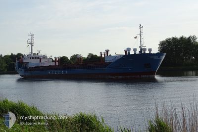
LEIRO
General Cargo

Current Trip
| Time Travelled | 16 h, 54 mins |
|---|---|
| Remaining Time | 1 day |
| Distance Travelled | 161.24 nm |
| Remaining Distance | 428.81 nm |
| AVG Speed | 9.6 Noeuds |
| MAX Speed | 10.6 Noeuds |
| AVG Wind | 8.9 knots |
| MAX Wind | 12 knots |
| MIN Temp | 3.9°C / 39.02°F |
| MAX Temp | 12.1°C / 53.78°F |
| Tirant d eau | 4.4 m |
| Position reçue | Maintenant |
Current Position
| Longitude | --- |
|---|---|
| Latitude | --- |
| Etat | Under way using engine |
| Vitesse | 10.2 Noeuds |
| Parcours | 358.8° |
| Zone | Kattegat |
| Station | T-AIS |
| Position reçue | Maintenant |
Information
The current position of LEIRO is in Kattegat with coordinates 57.79185° / 10.79233° as reported on 2025-03-21 09:02 by AIS to our vessel tracker app. The vessel's current speed is 10.2 Noeuds and is heading at the port of ARDALSTANGEN. The estimated time of arrival as calculated by MyShipTracking vessel tracking app is 2025-03-23 05:20 LT
The vessel LEIRO (IMO: 8017085, MMSI: 314298000) is a General Cargo that was built in 1981 ( 44 Age ). It's sailing under the flag of [BB] Barbados.
In this page you can find informations about the vessels current position, last detected port calls, and current voyage information. If the vessels is not in coverage by AIS you will find the latest position.
The current position of LEIRO is detected by our AIS receivers and we are not responsible for the reliability of the data. The last position was recorded while the vessel was in Coverage by the Ais receivers of our vessel tracking app.
The current draught of LEIRO as reported by AIS is 4.4 meters
Weather
| Temperature | 4.1°C / 39.38°F |
|---|---|
| Wind Speed | 11 knots |
| Direction | 101° E |
| Pressure | 1025.9 hPa |
| Humidity | 81 % |
| Cloud Coverage | 2 % |


Featured Company
Last Port Calls
| Port | Arrival | Departure | Time In Port |
|---|---|---|---|
| 2025-03-20 07:07 | 2025-03-20 17:09 | 10 h | |
| 2025-03-17 22:51 | 2025-03-18 14:48 | 15 h | |
| 2025-03-15 16:48 | 2025-03-16 10:21 | 17 h | |
| 2025-03-10 16:45 | 2025-03-11 08:07 | 15 h | |
| 2025-03-03 00:43 | 2025-03-04 05:40 | 1 d | |
| 2025-02-26 16:14 | 2025-02-27 21:22 | 1 d | |
| 2025-02-15 13:04 | 2025-02-17 15:49 | 2 d | |
| 2025-02-14 13:32 | 2025-02-15 08:17 | 18 h | |
| 2025-02-10 09:30 | 2025-02-10 22:05 | 12 h | |
| 2025-02-04 19:52 | 2025-02-05 11:17 | 15 h |
Most Visited Ports (Last year)
| Port | Arrivals | |
|---|---|---|
| 16 | ||
| 14 | ||
| 8 | ||
| 6 | ||
| 6 | ||
| 5 |
Last Trips
| Origin | Departure | Destination | Arrival | Distance | |
|---|---|---|---|---|---|
| 2025-03-18 14:48 | 2025-03-20 07:07 | 393.79 nm | |||
| 2025-03-16 10:21 | 2025-03-17 22:51 | 338.30 nm | |||
| 2025-03-11 08:07 | 2025-03-15 16:48 | 852.54 nm | |||
| 2025-03-04 05:40 | 2025-03-10 16:45 | 724.01 nm | |||
| 2025-02-27 21:22 | 2025-03-03 00:43 | 709.16 nm | |||
| 2025-02-17 15:49 | 2025-02-26 16:14 | 778.92 nm | |||
| 2025-02-15 08:17 | 2025-02-15 13:04 | 35.84 nm | |||
| 2025-02-10 22:05 | 2025-02-14 13:32 | 709.56 nm | |||
| 2025-02-05 11:17 | 2025-02-10 09:30 | 840.68 nm | |||
| 2025-02-01 11:31 | 2025-02-04 19:52 | 730.22 nm |
Events
| Heure | Evenement | Détails | Position/ Destination | Info |
|---|---|---|---|---|
| 2025-03-21 08:55 | Changement de zone | Danish part of the Skaggerak Danish part of the Kattegat |
57.77231 / 10.79311
Skaggerak
NOARD
|
Vitesse: 10.3 kn Parcours: 358.2° |
| 2025-03-20 16:09 | PORT DE DEPART |
|
55.28357 / 10.82089
NOARD
|
Vitesse: 9.4 kn Parcours: 125° |
| 2025-03-20 16:00 | Etat Changé | Under way using engine Moored |
55.29543 / 10.79264
[DK] NYBORG
|
Vitesse: 4.6 kn Parcours: 123° |
| 2025-03-20 15:59 | Démarrage |
55.29617 / 10.79098
[DK] NYBORG
|
Vitesse: 3.6 kn Parcours: 127° |
|
| 2025-03-20 15:26 | Tirant d'eau modifié | 4.4 3.5 |
55.29727 / 10.78913
[DK] NYBORG
|
Vitesse: Parcours: 135° |
| 2025-03-20 15:26 | Changement de destination | NOARD DKNBG |
55.29727 / 10.78913
[DK] NYBORG
|
Vitesse: Parcours: 135° |
| 2025-03-20 15:26 | Changement d'ETA | 2025/03/23 10:00 2025/03/20 08:00 |
55.29727 / 10.78913
[DK] NYBORG
|
Vitesse: Parcours: 135° |
| 2025-03-20 06:38 | Etat Changé | Moored Under way using engine |
55.29757 / 10.78862
[DK] NYBORG
|
Vitesse: Parcours: 135° |
| 2025-03-20 06:35 | Arret |
55.29753 / 10.78866
[DK] NYBORG
|
Vitesse: 0.3 kn Parcours: 137° |
|
| 2025-03-20 06:07 | Port d'arrivée |
|
55.28485 / 10.81800
[DK] NYBORG
|
Vitesse: 8.7 kn Parcours: 303° |