
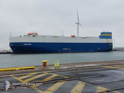
LAKE KIVU
Vehicles Carrier
Current Trip
| Time Travelled | 1 day |
|---|---|
| Remaining Time | 1 day |
| Distance Travelled | 542.15 nm |
| Remaining Distance | 372.93 nm |
| AVG Speed | 15.4 Noeuds |
| MAX Speed | 17.5 Noeuds |
| AVG Wind | 9.9 knots |
| MAX Wind | 18 knots |
| MIN Temp | 16.8°C / 62.24°F |
| MAX Temp | 19.1°C / 66.38°F |
| Tirant d eau | 8.8 m |
| Position reçue | 1 m depuis |
Current Position
| Longitude | -12.78483° |
|---|---|
| Latitude | 33.82347° |
| Etat | Under way using engine |
| Vitesse | 15.2 Noeuds |
| Parcours | 195° |
| Zone | North Atlantic Ocean |
| Station | T-AIS |
| Position reçue | 1 m depuis |
Info
Information
The current position of LAKE KIVU is in North Atlantic Ocean with coordinates 33.82347° / -12.78483° as reported on 2024-05-11 05:08 by AIS to our vessel tracker app. The vessel's current speed is 15.2 Noeuds and is heading at the port of LAS PALMAS. The estimated time of arrival as calculated by MyShipTracking vessel tracking app is 2024-05-12 05:25 LT
The vessel LAKE KIVU (IMO: 9308792, MMSI: 636015993) is a Vehicles Carrier that was built in 2006 ( 18 Age ). It's sailing under the flag of [LR] Liberia.
In this page you can find informations about the vessels current position, last detected port calls, and current voyage information. If the vessels is not in coverage by AIS you will find the latest position.
The current position of LAKE KIVU is detected by our AIS receivers and we are not responsible for the reliability of the data. The last position was recorded while the vessel was in Coverage by the Ais receivers of our vessel tracking app.
The current draught of LAKE KIVU as reported by AIS is 8.8 meters
Weather
| Temperature | 18.3°C / 64.94°F |
|---|---|
| Wind Speed | 18 knots |
| Direction | 3° N |
| Pressure | 1016.6 hPa |
| Humidity | 75.9 % |
| Cloud Coverage | 12 % |
Featured Company
Last Port Calls
| Port | Arrival | Departure | Time In Port |
|---|---|---|---|
| 2024-05-09 09:50 | 2024-05-09 17:51 | 8 h | |
| 2024-05-04 11:05 | 2024-05-06 22:52 | 2 d | |
| 2024-05-02 22:01 | 2024-05-03 15:00 | 16 h | |
| 2024-04-30 04:13 | 2024-04-30 15:02 | 10 h | |
| 2024-04-26 21:23 | 2024-04-28 08:41 | 1 d | |
| 2024-04-21 11:12 | 2024-04-22 21:59 | 1 d | |
| 2024-04-19 10:44 | 2024-04-20 14:37 | 1 d | |
| 2024-04-16 10:19 | 2024-04-16 18:15 | 7 h | |
| 2024-04-13 09:17 | 2024-04-14 20:42 | 1 d | |
| 2024-04-03 12:09 | 2024-04-04 21:46 | 1 d |
Most Visited Ports (Last year)
| Port | Arrivals | |
|---|---|---|
| 19 | ||
| 19 | ||
| 18 | ||
| 17 | ||
| 5 | ||
| 4 |
Last Trips
| Origin | Departure | Destination | Arrival | Distance | |
|---|---|---|---|---|---|
| 2024-05-07 00:52 | 2024-05-09 11:50 | 884.64 nm | |||
| 2024-05-03 17:00 | 2024-05-04 13:05 | 196.30 nm | |||
| 2024-04-30 17:02 | 2024-05-03 00:01 | 722.11 nm | |||
| 2024-04-28 09:41 | 2024-04-30 06:13 | 554.24 nm | |||
| 2024-04-22 23:59 | 2024-04-26 22:23 | 1376.89 nm | |||
| 2024-04-20 16:37 | 2024-04-21 13:12 | 201.38 nm | |||
| 2024-04-16 20:15 | 2024-04-19 12:44 | 717.92 nm | |||
| 2024-04-14 21:42 | 2024-04-16 12:19 | 538.25 nm | |||
| 2024-04-04 23:46 | 2024-04-13 09:17 | 2055.37 nm | |||
| 2024-04-02 15:23 | 2024-04-03 14:09 | 203.11 nm |
Events
| Heure | Evenement | Détails | Position/ Destination | Info |
|---|---|---|---|---|
| 2024-05-11 04:30 | Etat Changé | Under way using engine Default |
33.97480 / -12.72307
ES LPA
|
Vitesse: 15.1 kn Parcours: 200° |
| 2024-05-11 04:15 | Etat Changé | Default Under way using engine |
34.03508 / -12.69713
ES LPA
|
Vitesse: 15.2 kn Parcours: 200° |
| 2024-05-11 04:11 | Etat Changé | Under way using engine Default |
34.05093 / -12.69052
ES LPA
|
Vitesse: 15.2 kn Parcours: 199° |
| 2024-05-11 04:05 | Etat Changé | Default Under way using engine |
34.07300 / -12.68137
ES LPA
|
Vitesse: 15.2 kn Parcours: 198° |
| 2024-05-11 03:47 | Etat Changé | Under way using engine Default |
34.14660 / -12.65110
ES LPA
|
Vitesse: 15.5 kn Parcours: 198° |
| 2024-05-11 03:28 | Etat Changé | Default Under way using engine |
34.22662 / -12.61808
ES LPA
|
Vitesse: 15.3 kn Parcours: 199° |
| 2024-05-11 03:22 | Etat Changé | Under way using engine Default |
34.25003 / -12.60833
ES LPA
|
Vitesse: 15.2 kn Parcours: 199° |
| 2024-05-11 03:18 | Etat Changé | Default Under way using engine |
34.26742 / -12.60097
ES LPA
|
Vitesse: 15.2 kn Parcours: 198° |
| 2024-05-11 03:01 | Changement de zone | Portuguese (Madeira) part of the North Atlantic Ocean Moroccan part of the North Atlantic Ocean |
34.33200 / -12.57280
North Atlantic Ocean
ES LPA
|
Vitesse: 15.2 kn Parcours: 199° |
| 2024-05-11 03:01 | Etat Changé | Under way using engine Default |
34.33200 / -12.57280
ES LPA
|
Vitesse: 15.2 kn Parcours: 198° |