
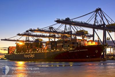
KUALA LUMPUR EXPRESS
Container Ship
Current Trip
| Trip Time | 11 h, 47 mins |
|---|---|
| Trip Distance | 191.40 nm |
| AVG Speed | 15.5 Noeuds |
| MAX Speed | 21 Noeuds |
| Tirant d eau | 12.7 m |
| AVG Wind | 7.1 knots |
| MAX Wind | 16 knots |
| MIN Temp | 5.7°C / 42.26°F |
| MAX Temp | 10.8°C / 51.44°F |
| Position reçue | 1 m depuis |
Current Position
| Longitude | --- |
|---|---|
| Latitude | --- |
| Etat | Moored |
| Vitesse | |
| Parcours | 112° |
| Zone | The Coastal Waters of Southeast Alaska and British Columbia |
| Station | T-AIS |
| Position reçue | 1 m depuis |
Info
Information
The current position of KUALA LUMPUR EXPRESS is in The Coastal Waters of Southeast Alaska and British Columbia with coordinates 49.29033° / -123.09923° as reported on 2025-03-18 06:46 by AIS to our vessel tracker app. The vessel's current speed is 0 Noeuds and is currently inside the port of VANCOUVER.
The vessel KUALA LUMPUR EXPRESS (IMO: 9343730, MMSI: 218284000) is a Container Ship that was built in 2007 ( 18 Age ). It's sailing under the flag of [DE] Germany.
In this page you can find informations about the vessels current position, last detected port calls, and current voyage information. If the vessels is not in coverage by AIS you will find the latest position.
The current position of KUALA LUMPUR EXPRESS is detected by our AIS receivers and we are not responsible for the reliability of the data. The last position was recorded while the vessel was in Coverage by the Ais receivers of our vessel tracking app.
The current draught of KUALA LUMPUR EXPRESS as reported by AIS is 12.6 meters
Weather
| Temperature | 2.1°C / 35.78°F |
|---|---|
| Wind Speed | 2 knots |
| Direction | 16° NNE |
| Pressure | 1017.7 hPa |
| Humidity | 83 % |
| Cloud Coverage | 91 % |
Featured Company
Last Port Calls
| Port | Arrival | Departure | Time In Port |
|---|---|---|---|
| 2025-03-15 04:01 | |||
| 2025-03-09 14:31 | 2025-03-14 16:14 | 5 d | |
| 2025-02-23 09:45 | 2025-02-24 14:51 | 1 d | |
| 2025-02-19 01:37 | 2025-02-19 22:57 | 21 h | |
| 2025-01-06 13:50 | 2025-01-07 14:42 | 1 d | |
| 2025-01-04 14:18 | 2025-01-06 02:10 | 1 d |
Most Visited Ports (Last year)
| Port | Arrivals | |
|---|---|---|
| 4 | ||
| 3 | ||
| 3 | ||
| 3 | ||
| 3 | ||
| 3 |
Last Trips
| Origin | Departure | Destination | Arrival | Distance | |
|---|---|---|---|---|---|
| 2025-03-14 16:14 | 2025-03-15 04:01 | 191.40 nm | |||
| 2025-02-24 14:51 | 2025-03-09 14:31 | 4708.42 nm | |||
| 2025-02-19 22:57 | 2025-02-23 09:45 | 567.45 nm | |||
| 2025-01-07 14:42 | 2025-02-19 01:37 | 11270.14 nm | |||
| 2025-01-06 02:10 | 2025-01-06 13:50 | 117.98 nm | |||
| 2024-12-31 13:35 | 2025-01-04 14:18 | 509.00 nm |
Events
| Heure | Evenement | Détails | Position/ Destination | Info |
|---|---|---|---|---|
| 2025-03-16 00:54 | Tirant d'eau modifié | 12.6 12.7 |
49.29031 / -123.09917
[CA] VANCOUVER
|
Vitesse: Parcours: 113° |
| 2025-03-16 00:54 | Changement de destination | JPYOK CAVAN |
49.29031 / -123.09917
[CA] VANCOUVER
|
Vitesse: Parcours: 113° |
| 2025-03-16 00:54 | Changement d'ETA | 2025/03/31 22:00 2025/03/15 06:00 |
49.29031 / -123.09917
[CA] VANCOUVER
|
Vitesse: Parcours: 113° |
| 2025-03-15 12:12 | Etat Changé | Moored Under way using engine |
49.29029 / -123.09919
[CA] VANCOUVER
|
Vitesse: Parcours: 112° |
| 2025-03-15 11:36 | Arret |
49.29103 / -123.10038
[CA] VANCOUVER
|
Vitesse: 0.3 kn Parcours: 112° |
|
| 2025-03-15 11:01 | Port d'arrivée |
|
49.31747 / -123.14619
[CA] VANCOUVER
|
Vitesse: 7.1 kn Parcours: 108.2° |
| 2025-03-15 09:19 | Changement de zone | Canadian part of the The Coastal Waters of Southeast Alaska and British Columbia United States part of the The Coastal Waters of Southeast Alaska and British Columbia |
49.00858 / -123.25488
The Coastal Waters of Southeast Alaska and British Columbia
CAVAN
|
Vitesse: 18 kn Parcours: 313.7° |
| 2025-03-15 08:19 | Changement de zone | United States part of the The Coastal Waters of Southeast Alaska and British Columbia Canadian part of the The Coastal Waters of Southeast Alaska and British Columbia |
48.79633 / -123.00247
The Coastal Waters of Southeast Alaska and British Columbia
CAVAN
|
Vitesse: 16.8 kn Parcours: 26.6° |
| 2025-03-15 07:55 | Changement de zone | Canadian part of the The Coastal Waters of Southeast Alaska and British Columbia United States part of the The Coastal Waters of Southeast Alaska and British Columbia |
48.73077 / -123.13538
The Coastal Waters of Southeast Alaska and British Columbia
CAVAN
|
Vitesse: 16.4 kn Parcours: 64.2° |
| 2025-03-15 06:49 | Changement de zone | United States part of the The Coastal Waters of Southeast Alaska and British Columbia Canadian part of the The Coastal Waters of Southeast Alaska and British Columbia |
48.46321 / -123.16315
The Coastal Waters of Southeast Alaska and British Columbia
CAVAN
|
Vitesse: 17.6 kn Parcours: 0° |