
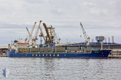
IRYDA
Bulk Carrier
Current Trip
| Trip Time | 10 days |
|---|---|
| Trip Distance | 1073.08 nm |
| AVG Speed | 12.2 Noeuds |
| MAX Speed | 14.2 Noeuds |
| Tirant d eau | 6.4 m |
| AVG Wind | 7.2 knots |
| MAX Wind | 18 knots |
| MIN Temp | 14.9°C / 58.82°F |
| MAX Temp | 21.5°C / 70.7°F |
| Position reçue | 5 d depuis |
Current Position
| Longitude | 7.82448° |
|---|---|
| Latitude | 36.92299° |
| Etat | At anchor |
| Vitesse | |
| Parcours | 315° |
| Zone | Mediterranean Sea - Western Basin |
| Station | T-AIS |
| Position reçue | 5 d depuis |
Info
Information
The current position of IRYDA is in Mediterranean Sea - Western Basin with coordinates 36.92299° / 7.82448° as reported on 2024-05-16 19:41 by AIS to our vessel tracker app. The vessel's current speed is 0 Noeuds and is currently inside the port of ANNABA.
The vessel IRYDA (IMO: 9180384, MMSI: 212891000) is a Bulk Carrier that was built in 1999 ( 25 Age ). It's sailing under the flag of [CY] Cyprus.
In this page you can find informations about the vessels current position, last detected port calls, and current voyage information. If the vessels is not in coverage by AIS you will find the latest position.
The current position of IRYDA is detected by our AIS receivers and we are not responsible for the reliability of the data. The last position was recorded while the vessel was in Coverage by the Ais receivers of our vessel tracking app.
The current draught of IRYDA as reported by AIS is 6.4 meters
Weather
| Temperature | 17.6°C / 63.68°F |
|---|---|
| Wind Speed | 5 knots |
| Direction | 200° SSW |
| Pressure | 1018.3 hPa |
| Humidity | 73 % |
| Cloud Coverage | --- |
Featured Company
Last Port Calls
| Port | Arrival | Departure | Time In Port |
|---|---|---|---|
| 2024-05-17 18:13 | |||
| 2024-04-30 12:20 | 2024-05-07 06:44 | 6 d | |
| 2024-03-31 02:05 | 2024-04-04 07:29 | 4 d | |
| 2024-03-26 05:44 | 2024-03-27 01:50 | 20 h | |
| 2024-03-19 21:29 | 2024-03-23 07:35 | 3 d | |
| 2024-03-12 11:04 | 2024-03-14 02:24 | 1 d |
Most Visited Ports (Last year)
| Port | Arrivals | |
|---|---|---|
| 3 | ||
| 3 | ||
| 3 | ||
| 2 | ||
| 2 | ||
| 2 |
Last Trips
| Origin | Departure | Destination | Arrival | Distance | |
|---|---|---|---|---|---|
| 2024-05-07 08:44 | 2024-05-17 19:13 | 1073.08 nm | |||
| 2024-04-04 02:29 | 2024-04-30 14:20 | 6627.75 nm | |||
| 2024-03-26 20:50 | 2024-03-30 21:05 | 73.33 nm | |||
| 2024-03-23 02:35 | 2024-03-26 00:44 | 438.88 nm | |||
| 2024-03-13 22:24 | 2024-03-19 16:29 | 1412.45 nm | |||
| 2024-02-21 02:28 | 2024-03-12 07:04 | 4196.27 nm |
Events
| Heure | Evenement | Détails | Position/ Destination | Info |
|---|---|---|---|---|
| 2024-05-17 18:35 | Arret |
36.89667 / 7.76833
[DZ] ANNABA
|
Vitesse: Parcours: -1° |
|
| 2024-05-17 18:13 | Port d'arrivée |
|
36.90301 / 7.78061
[DZ] ANNABA
|
Vitesse: 3 kn Parcours: -1° |
| 2024-05-17 17:08 | Démarrage | 2.47 nm, East of ANNABA |
36.91985 / 7.82620
DZ AAE
|
Vitesse: 3.8 kn Parcours: 224° |
| 2024-05-16 19:44 | Etat Changé | Default At anchor |
36.92166 / 7.82333
DZ AAE
|
Vitesse: Parcours: 315° |
| 2024-05-16 19:41 | Hors de la zone couverte |
36.92299 / 7.82448
Mediterranean Sea - Western Basin
|
Vitesse: Parcours: 22.4° |
|
| 2024-05-16 19:26 | Etat Changé | At anchor Default |
36.92288 / 7.82436
DZ AAE
|
Vitesse: Parcours: 324° |
| 2024-05-16 19:26 | Dans la zone couverte |
36.92288 / 7.82436
Mediterranean Sea - Western Basin
|
Vitesse: 0.1 kn Parcours: 22.4° |
|
| 2024-05-16 18:08 | Etat Changé | Default At anchor |
36.92166 / 7.82333
DZ AAE
|
Vitesse: Parcours: 337° |
| 2024-05-16 18:02 | Hors de la zone couverte |
36.92252 / 7.82392
Mediterranean Sea - Western Basin
|
Vitesse: Parcours: 54.6° |
|
| 2024-05-16 17:41 | Etat Changé | At anchor Default |
36.92247 / 7.82388
DZ AAE
|
Vitesse: Parcours: -1° |