
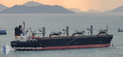
GLORIOUS HIBISCUS
Wood Chips Carrier
Current Trip
| Trip Time | 23 days |
|---|---|
| Trip Distance | 4178.96 nm |
| AVG Speed | 10 Noeuds |
| MAX Speed | 13.8 Noeuds |
| Tirant d eau | 10.1 m |
| AVG Wind | 10.9 knots |
| MAX Wind | 30.8 knots |
| MIN Temp | 18.4°C / 65.12°F |
| MAX Temp | 29.8°C / 85.64°F |
| Position reçue | 2 h, 28 m depuis |
Current Position
| Longitude | --- |
|---|---|
| Latitude | --- |
| Etat | Under way using engine |
| Vitesse | 2.2 Noeuds |
| Parcours | 180° |
| Zone | Philippine Sea |
| Station | T-AIS |
| Position reçue | 2 h, 28 m depuis |
Info
Information
The current position of GLORIOUS HIBISCUS is in Philippine Sea with coordinates 33.99721° / 134.61842° as reported on 2024-10-04 21:54 by AIS to our vessel tracker app. The vessel's current speed is 2.2 Noeuds and is currently inside the port of KOMATSUSHIMA.
The vessel GLORIOUS HIBISCUS (IMO: 9515216, MMSI: 373048000) is a Wood Chips Carrier that was built in 2012 ( 12 Age ). It's sailing under the flag of [PA] Panama.
In this page you can find informations about the vessels current position, last detected port calls, and current voyage information. If the vessels is not in coverage by AIS you will find the latest position.
The current position of GLORIOUS HIBISCUS is detected by our AIS receivers and we are not responsible for the reliability of the data. The last position was recorded while the vessel was in Coverage by the Ais receivers of our vessel tracking app.
The current draught of GLORIOUS HIBISCUS as reported by AIS is 10.1 meters
Weather
| Temperature | 18.8°C / 65.84°F |
|---|---|
| Wind Speed | 5 knots |
| Direction | 337° NNW |
| Pressure | 1021.7 hPa |
| Humidity | 87.6 % |
| Cloud Coverage | 100 % |
Featured Company
Last Port Calls
| Port | Arrival | Departure | Time In Port |
|---|---|---|---|
| 2024-10-04 21:39 | |||
| 2024-09-07 05:17 | 2024-09-11 10:21 | 4 d | |
| 2024-08-04 21:21 | 2024-08-08 01:21 | 3 d |
Most Visited Ports (Last year)
| Port | Arrivals | |
|---|---|---|
| 4 | ||
| 4 | ||
| 3 | ||
| 2 | ||
| 2 | ||
| 1 |
Last Trips
| Origin | Departure | Destination | Arrival | Distance | |
|---|---|---|---|---|---|
| 2024-09-11 19:21 | 2024-10-05 06:39 | 4178.96 nm | |||
| 2024-08-08 10:21 | 2024-09-07 14:17 | 6056.93 nm | |||
| 2024-07-05 06:04 | 2024-08-05 06:21 | 5921.31 nm |
Events
| Heure | Evenement | Détails | Position/ Destination | Info |
|---|---|---|---|---|
| 2024-10-04 22:09 | Arret |
33.99450 / 134.62006
[JP] KOMATSUSHIMA
|
Vitesse: 0.1 kn Parcours: 241° |
|
| 2024-10-04 22:01 | Etat Changé | Default Under way using engine |
33.99492 / 134.61990
[JP] KOMATSUSHIMA
|
Vitesse: 2.2 kn Parcours: 180° |
| 2024-10-04 21:54 | Hors de la zone couverte |
33.99721 / 134.61842
Philippine Sea
[JP] KOMATSUSHIMA
|
Vitesse: 2.2 kn Parcours: 162.3° |
|
| 2024-10-04 21:39 | Port d'arrivée |
|
34.01152 / 134.61780
[JP] KOMATSUSHIMA
|
Vitesse: 5.2 kn Parcours: 191.2° |
| 2024-10-04 21:31 | Etat Changé | Under way using engine Default |
34.02208 / 134.62367
JP KOM
|
Vitesse: 6.3 kn Parcours: 261° |
| 2024-10-04 21:01 | Etat Changé | Default Under way using engine |
34.02277 / 134.67584
JP KOM
|
Vitesse: 3.4 kn Parcours: 290° |
| 2024-10-04 20:51 | Etat Changé | Under way using engine Default |
34.01967 / 134.68706
JP KOM
|
Vitesse: 4.1 kn Parcours: 302° |
| 2024-10-04 20:29 | Etat Changé | Default Under way using engine |
34.00030 / 134.71790
JP KOM
|
Vitesse: 5.8 kn Parcours: 308.1° |
| 2024-10-04 19:43 | Changement d'ETA | 2024/10/04 21:30 2024/10/01 23:00 |
33.93494 / 134.81978
JP KOM
|
Vitesse: 9.7 kn Parcours: 303.5° |
| 2024-10-04 19:21 | Dans la zone couverte |
33.90389 / 134.86634
Philippine Sea
|
Vitesse: 6.9 kn Parcours: 306.6° |