
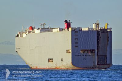
GEORGIA HIGHWAY
Cargo
Current Trip
| Time Travelled | 6 days |
|---|---|
| Remaining Time | --- |
| Distance Travelled | 1591.59 nm |
| Remaining Distance | --- |
| AVG Speed | 15.1 Noeuds |
| MAX Speed | 19.5 Noeuds |
| AVG Wind | 8.6 knots |
| MAX Wind | 20.2 knots |
| MIN Temp | 25.1°C / 77.18°F |
| MAX Temp | 32.6°C / 90.68°F |
| Tirant d eau | 7 m |
| Position reçue | 37 m depuis |
Current Position
| Longitude | -79.53961° |
|---|---|
| Latitude | 8.82124° |
| Etat | At anchor |
| Vitesse | |
| Parcours | 177° |
| Zone | North Pacific Ocean |
| Station | T-AIS |
| Position reçue | 37 m depuis |
Info
Information
The current position of GEORGIA HIGHWAY is in North Pacific Ocean with coordinates 8.82124° / -79.53961° as reported on 2024-06-05 04:30 by AIS to our vessel tracker app. The vessel's current speed is 0 Noeuds
The vessel GEORGIA HIGHWAY (MMSI: 432629000) is a Cargo It's sailing under the flag of [JP] Japan.
In this page you can find informations about the vessels current position, last detected port calls, and current voyage information. If the vessels is not in coverage by AIS you will find the latest position.
The current position of GEORGIA HIGHWAY is detected by our AIS receivers and we are not responsible for the reliability of the data. The last position was recorded while the vessel was in Coverage by the Ais receivers of our vessel tracking app.
The current draught of GEORGIA HIGHWAY as reported by AIS is 7 meters
Weather
| Temperature | 28.5°C / 83.3°F |
|---|---|
| Wind Speed | 13 knots |
| Direction | 186° S |
| Pressure | 1010.4 hPa |
| Humidity | 80.5 % |
| Cloud Coverage | 95 % |
Featured Company
Last Port Calls
| Port | Arrival | Departure | Time In Port |
|---|---|---|---|
| 2024-05-27 21:05 | 2024-05-29 14:40 | 1 d | |
| 2024-05-15 13:46 | 2024-05-17 02:46 | 1 d | |
| 2024-05-11 07:19 | 2024-05-12 22:00 | 1 d | |
| 2024-05-08 13:39 | 2024-05-11 02:13 | 2 d | |
| 2024-05-06 03:59 | 2024-05-06 18:18 | 14 h | |
| 2024-04-30 18:47 | 2024-05-02 07:45 | 1 d |
Last Trips
| Origin | Departure | Destination | Arrival | Distance | |
|---|---|---|---|---|---|
| 2024-05-17 02:46 | 2024-05-27 21:05 | 4248.74 nm | |||
| 2024-05-12 22:00 | 2024-05-15 13:46 | 357.39 nm | |||
| 2024-05-11 02:13 | 2024-05-11 07:19 | 55.46 nm | |||
| 2024-05-06 18:18 | 2024-05-08 13:39 | 596.15 nm | |||
| 2024-05-02 07:45 | 2024-05-06 03:59 | 1614.55 nm | |||
| 2024-03-26 18:16 | 2024-04-30 18:47 | 14737.22 nm |
Events
| Heure | Evenement | Détails | Position/ Destination | Info |
|---|---|---|---|---|
| 2024-06-05 04:37 | Etat Changé | Default At anchor |
8.82122 / -79.53969
PACTB
|
Vitesse: Parcours: 177° |
| 2024-06-05 04:30 | Etat Changé | At anchor Default |
8.82124 / -79.53961
PACTB
|
Vitesse: Parcours: 175° |
| 2024-06-05 04:01 | Etat Changé | Default At anchor |
8.82120 / -79.53959
PACTB
|
Vitesse: Parcours: 211° |
| 2024-06-05 03:57 | Etat Changé | At anchor Default |
8.82123 / -79.53947
PACTB
|
Vitesse: Parcours: 217° |
| 2024-06-05 03:22 | Etat Changé | Default At anchor |
8.82081 / -79.53964
PACTB
|
Vitesse: Parcours: 312° |
| 2024-06-05 03:21 | Etat Changé | At anchor Default |
8.82074 / -79.53965
PACTB
|
Vitesse: Parcours: 315° |
| 2024-06-05 03:01 | Etat Changé | Default At anchor |
8.82061 / -79.53968
PACTB
|
Vitesse: Parcours: 317° |
| 2024-06-05 02:54 | Etat Changé | At anchor Default |
8.82065 / -79.53968
PACTB
|
Vitesse: Parcours: 316° |
| 2024-06-05 02:33 | Etat Changé | Default At anchor |
8.82059 / -79.53960
PACTB
|
Vitesse: Parcours: 308° |
| 2024-06-05 02:27 | Detecté en mer | Panamanian part of the North Pacific Ocean |
8.82054 / -79.53951
North Pacific Ocean
|
Vitesse: Parcours: 259° |