
FALCON-UA
Reefer
Current Trip
| Time Travelled | 1 day |
|---|---|
| Remaining Time | --- |
| Distance Travelled | 318.89 nm |
| Remaining Distance | --- |
| AVG Speed | 9.9 Noeuds |
| MAX Speed | 12.3 Noeuds |
| AVG Wind | 8.5 knots |
| MAX Wind | 12.3 knots |
| MIN Temp | 10.5°C / 50.9°F |
| MAX Temp | 18°C / 64.4°F |
| Tirant d eau | 4.1 m |
| Position reçue | 2 m depuis |
Current Position
| Longitude | 29.05837° |
|---|---|
| Latitude | 41.27743° |
| Etat | At anchor |
| Vitesse | 0.3 Noeuds |
| Parcours | 352° |
| Zone | Black Sea |
| Station | T-AIS |
| Position reçue | 2 m depuis |
Info
Information
The current position of FALCON-UA is in Black Sea with coordinates 41.27743° / 29.05837° as reported on 2024-05-13 16:19 by AIS to our vessel tracker app. The vessel's current speed is 0.3 Noeuds and is heading at the port of MERSIN. The estimated time of arrival as calculated by MyShipTracking vessel tracking app is 2024-05-17 08:00 LT
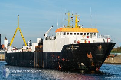
The vessel FALCON-UA (IMO: 8300327, MMSI: 511100982) is a Reefer that was built in 1984 ( 40 Age ). It's sailing under the flag of [PW] Palau.
In this page you can find informations about the vessels current position, last detected port calls, and current voyage information. If the vessels is not in coverage by AIS you will find the latest position.
The current position of FALCON-UA is detected by our AIS receivers and we are not responsible for the reliability of the data. The last position was recorded while the vessel was in Coverage by the Ais receivers of our vessel tracking app.
The current draught of FALCON-UA as reported by AIS is 4.1 meters
Weather
| Temperature | 12.1°C / 53.78°F |
|---|---|
| Wind Speed | 7 knots |
| Direction | 51° NE |
| Pressure | 1019.2 hPa |
| Humidity | 72.8 % |
| Cloud Coverage | 22 % |
Featured Company
Last Port Calls
| Port | Arrival | Departure | Time In Port |
|---|---|---|---|
| 2024-05-11 16:44 | |||
| 2024-05-03 06:21 | 2024-05-03 06:41 | 19 m | |
| 2024-04-13 04:53 | 2024-04-16 05:27 | 3 d | |
| 2024-04-04 21:41 | 2024-04-09 01:40 | 4 d | |
| 2024-03-15 11:30 | 2024-03-28 09:49 | 12 d | |
| 2024-03-13 21:33 |
Most Visited Ports (Last year)
| Port | Arrivals | |
|---|---|---|
| 1 | ||
| 1 | ||
| 1 | ||
| 1 | ||
| 1 | ||
| 1 |
Last Trips
| Origin | Departure | Destination | Arrival | Distance | |
|---|---|---|---|---|---|
| 2024-04-16 08:27 | 2024-05-03 09:21 | 1091.52 nm | |||
| 2024-04-09 03:40 | 2024-04-13 07:53 | 717.89 nm | |||
| 2024-03-28 11:49 | 2024-04-04 23:41 | 730.81 nm | |||
| 2024-03-13 23:33 | 2024-03-15 13:30 | 300.61 nm |
Events
| Heure | Evenement | Détails | Position/ Destination | Info |
|---|---|---|---|---|
| 2024-05-13 16:00 | Etat Changé | At anchor Under way using engine |
41.27813 / 29.05858
TRMER
|
Vitesse: 0.4 kn Parcours: 126° |
| 2024-05-13 16:00 | Arret | 3.74 nm, North West of RUMELI FENERI |
41.27813 / 29.05858
TRMER
|
Vitesse: 0.2 kn Parcours: 128° |
| 2024-05-13 14:48 | Tirant d'eau modifié | 4.1 3.5 |
41.45276 / 29.02941
TRMER
|
Vitesse: 10.7 kn Parcours: 176.3° |
| 2024-05-13 14:48 | Changement de destination | TRMER RO SUL |
41.45276 / 29.02941
TRMER
|
Vitesse: 10.7 kn Parcours: 176.3° |
| 2024-05-13 14:48 | Changement d'ETA | 2024/05/17 08:00 2024/04/29 06:00 |
41.45276 / 29.02941
TRMER
|
Vitesse: 10.7 kn Parcours: 176.3° |
| 2024-05-13 14:47 | Etat Changé | Under way using engine Default |
41.45276 / 29.02941
RO SUL
|
Vitesse: 10.6 kn Parcours: 176° |
| 2024-05-13 14:47 | Dans la zone couverte |
41.44879 / 29.02991
Black Sea
TRMER
|
Vitesse: 10.8 kn Parcours: 175.4° |
|
| 2024-05-12 05:20 | Démarrage | 0.91 nm, North West of RENI |
45.44854 / 28.27449
RO SUL
|
Vitesse: 9.1 kn Parcours: 139° |
| 2024-05-11 17:11 | Arret | 1.31 nm, North West of RENI |
45.45426 / 28.26965
RO SUL
|
Vitesse: 0.1 kn Parcours: 305° |
| 2024-05-11 16:44 | PORT DE DEPART |
|
45.44253 / 28.28174
RO SUL
|
Vitesse: 5.3 kn Parcours: 347° |