
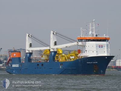
EEMSLIFT DAFNE
General Cargo
Current Trip
AO SZA
| Time Travelled | 22 days |
|---|---|
| Remaining Time | --- |
| Distance Travelled | 236.36 nm |
| Remaining Distance | --- |
| AVG Speed | 8.3 Noeuds |
| MAX Speed | 13.5 Noeuds |
| AVG Wind | 7.6 knots |
| MAX Wind | 13.8 knots |
| MIN Temp | 24.4°C / 75.92°F |
| MAX Temp | 27.3°C / 81.14°F |
| Tirant d eau | 5.4 m |
| Position reçue | 2025-11-02 11:38 |
Current Position
| Longitude | --- |
|---|---|
| Latitude | --- |
| Etat | Under way using engine |
| Vitesse | 13.2 Noeuds |
| Parcours | 146.9° |
| Zone | North Atlantic Ocean |
| Station | T-AIS |
| Position reçue | 2025-11-02 11:38 |
Info
Information
The current position of EEMSLIFT DAFNE is in North Atlantic Ocean with coordinates 11.05951° / -18.62218° as reported on 2025-11-02 11:38 by AIS to our vessel tracker app. The vessel's current speed is 13.2 Noeuds
The vessel EEMSLIFT DAFNE (IMO: 9671448, MMSI: 244810443) is a General Cargo that was built in 2014 ( 12 Age ). It's sailing under the flag of [NL] Netherlands.
In this page you can find informations about the vessels current position, last detected port calls, and current voyage information. If the vessels is not in coverage by AIS you will find the latest position.
The current position of EEMSLIFT DAFNE is detected by our AIS receivers and we are not responsible for the reliability of the data. The last position was recorded while the vessel was in Coverage by the Ais receivers of our vessel tracking app.
The current draught of EEMSLIFT DAFNE as reported by AIS is 5.4 meters
Weather
| Temperature | 25.8°C / 78.44°F |
|---|---|
| Wind Speed | 5 knots |
| Direction | 295° WNW |
| Pressure | 1012.1 hPa |
| Humidity | 72.2 % |
| Cloud Coverage | 37 % |
Featured Company
Last Trips
| Origin | Departure | Destination | Arrival | Distance | |
|---|---|---|---|---|---|
| 2025-11-11 11:07 | 2025-12-11 11:08 | 208.42 nm | |||
| 2025-10-30 07:22 | 2025-11-10 09:43 | 3264.58 nm |
Events
| Heure | Evenement | Détails | Position/ Destination | Info |
|---|---|---|---|---|
| 2026-01-02 08:22 | Arret | 3.21 nm, North West of SOYO |
-6.06973 / 12.29841
AO SZA
|
Vitesse: 0.2 kn Parcours: 95° |
| 2026-01-02 07:40 | Démarrage | 4.72 nm, North West of SOYO |
-6.08008 / 12.25878
AO SZA
|
Vitesse: 5.5 kn Parcours: 68° |
| 2025-12-29 22:11 | Arret | 4.8 nm, West of SOYO |
-6.08293 / 12.25609
AO SZA
|
Vitesse: 0.1 kn Parcours: 79° |
| 2025-12-29 15:49 | Démarrage |
-6.05617 / 11.08141
AO SZA
|
Vitesse: 4.3 kn Parcours: 287° |
|
| 2025-12-29 05:29 | Arret |
-6.04770 / 11.07927
AO SZA
|
Vitesse: 0.3 kn Parcours: 299° |
|
| 2025-12-29 04:43 | Démarrage |
-6.08593 / 11.11348
AO SZA
|
Vitesse: 5.1 kn Parcours: 336° |
|
| 2025-12-28 23:37 | Arret |
-6.09121 / 11.09966
AO SZA
|
Vitesse: 0.3 kn Parcours: 95° |
|
| 2025-12-28 15:59 | Démarrage |
-6.11563 / 11.00355
AO SZA
|
Vitesse: 3.6 kn Parcours: 305° |
|
| 2025-12-28 12:33 | Arret |
-6.12512 / 11.00639
AO SZA
|
Vitesse: 0.3 kn Parcours: 125° |
|
| 2025-12-28 09:34 | Démarrage |
-5.94217 / 11.05229
AO SZA
|
Vitesse: 5.2 kn Parcours: 184° |