

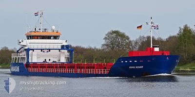
EEMS ROVER
General Cargo

Current Trip
| Time Travelled | 7 days |
|---|---|
| Remaining Time | 10 days |
| Distance Travelled | 1380.24 nm |
| Remaining Distance | 2064.39 nm |
| AVG Speed | 8.8 Noeuds |
| MAX Speed | 12 Noeuds |
| AVG Wind | 8 knots |
| MAX Wind | 26 knots |
| MIN Temp | 4.4°C / 39.92°F |
| MAX Temp | 19°C / 66.2°F |
| Tirant d eau | 6.1 m |
| Position reçue | 1 d depuis |
Current Position
| Longitude | --- |
|---|---|
| Latitude | --- |
| Etat | Under way using engine |
| Vitesse | 9.5 Noeuds |
| Parcours | 272.3° |
| Zone | Mediterranean Sea - Western Basin |
| Station | T-AIS |
| Position reçue | 1 d depuis |
Information
The current position of EEMS ROVER is in Mediterranean Sea - Western Basin with coordinates 37.65787° / 11.71803° as reported on 2025-03-27 00:41 by AIS to our vessel tracker app. The vessel's current speed is 9.5 Noeuds and is heading at the port of ROTTERDAM. The estimated time of arrival as calculated by MyShipTracking vessel tracking app is 2025-04-08 01:00 LT
The vessel EEMS ROVER (IMO: 9529190, MMSI: 246063000) is a General Cargo that was built in 2009 ( 16 Age ). It's sailing under the flag of [NL] Netherlands.
In this page you can find informations about the vessels current position, last detected port calls, and current voyage information. If the vessels is not in coverage by AIS you will find the latest position.
The current position of EEMS ROVER is detected by our AIS receivers and we are not responsible for the reliability of the data. The last position was recorded while the vessel was in Coverage by the Ais receivers of our vessel tracking app.
The current draught of EEMS ROVER as reported by AIS is 6.1 meters
Weather
| Temperature | 15.7°C / 60.26°F |
|---|---|
| Wind Speed | 6 knots |
| Direction | 309° NW |
| Pressure | 1012.9 hPa |
| Humidity | 67.3 % |
| Cloud Coverage | 12 % |


Featured Company
Last Port Calls
| Port | Arrival | Departure | Time In Port |
|---|---|---|---|
| 2025-03-17 20:08 | 2025-03-21 12:36 | 3 d | |
| 2025-03-13 21:49 | 2025-03-15 23:20 | 2 d | |
| 2025-02-22 17:36 | 2025-02-23 14:12 | 20 h | |
| 2025-02-18 14:38 | 2025-02-22 13:20 | 3 d | |
| 2025-02-10 19:15 | 2025-02-14 23:20 | 4 d | |
| 2025-02-05 08:22 | 2025-02-07 00:13 | 1 d | |
| 2025-01-31 11:41 | |||
| 2025-01-26 02:00 | 2025-01-29 21:27 | 3 d | |
| 2025-01-22 01:15 | 2025-01-24 05:43 | 2 d | |
| 2025-01-18 00:36 | 2025-01-20 21:45 | 2 d |
Most Visited Ports (Last year)
| Port | Arrivals | |
|---|---|---|
| 3 | ||
| 3 | ||
| 2 | ||
| 2 | ||
| 2 | ||
| 2 |
Last Trips
| Origin | Departure | Destination | Arrival | Distance | |
|---|---|---|---|---|---|
| 2025-03-15 23:20 | 2025-03-17 20:08 | 252.06 nm | |||
| 2025-02-23 14:12 | 2025-03-13 21:49 | 3253.37 nm | |||
| 2025-02-22 13:20 | 2025-02-22 17:36 | 22.44 nm | |||
| 2025-02-14 23:20 | 2025-02-18 14:38 | 855.48 nm | |||
| 2025-02-07 00:13 | 2025-02-10 19:15 | 926.86 nm | |||
| 2025-01-29 21:27 | 2025-02-05 08:22 | 372.83 nm | |||
| 2025-01-29 21:27 | 2025-01-31 11:41 | 371.21 nm | |||
| 2025-01-24 05:43 | 2025-01-26 02:00 | 361.13 nm | |||
| 2025-01-20 21:45 | 2025-01-22 01:15 | 113.98 nm | |||
| 2025-01-11 01:16 | 2025-01-18 00:36 | 237.00 nm |
Events
| Heure | Evenement | Détails | Position/ Destination | Info |
|---|---|---|---|---|
| 2025-03-27 00:52 | Etat Changé | Default Under way using engine |
37.65939 / 11.68050
NLRTM
|
Vitesse: 9.5 kn Parcours: 272.3° |
| 2025-03-27 00:41 | Hors de la zone couverte |
37.65787 / 11.71803
Mediterranean Sea - Western Basin
NLRTM
|
Vitesse: 9.5 kn Parcours: 272.3° |
|
| 2025-03-26 23:39 | Detecté en mer | Italian part of the Mediterranean Sea - Western Basin |
37.62916 / 11.92632
Mediterranean Sea - Western Basin
NLRTM
|
Vitesse: 10.3 kn Parcours: 300.3° |
| 2025-03-26 23:39 | Etat Changé | Under way using engine Default |
37.62916 / 11.92632
NLRTM
|
Vitesse: 10.2 kn Parcours: 299° |
| 2025-03-26 23:07 | Etat Changé | Default Under way using engine |
37.58291 / 12.02888
NLRTM
|
Vitesse: 10.3 kn Parcours: 300.6° |
| 2025-03-26 22:58 | Etat Changé | Under way using engine Default |
37.57025 / 12.05579
NLRTM
|
Vitesse: 10.4 kn Parcours: 299° |
| 2025-03-26 22:45 | Dans la zone couverte |
37.57125 / 12.05366
Mediterranean Sea - Eastern Basin
NLRTM
|
Vitesse: 10.3 kn Parcours: 300.6° |
|
| 2025-03-26 13:16 | Etat Changé | Default Under way using engine |
36.86898 / 13.71402
NLRTM
|
Vitesse: 9 kn Parcours: 297.2° |
| 2025-03-26 12:25 | Hors de la zone couverte |
36.81114 / 13.85298
Mediterranean Sea - Eastern Basin
NLRTM
|
Vitesse: 9 kn Parcours: 297.2° |
|
| 2025-03-26 10:35 | Changement d'ETA | 2025/04/05 02:00 2025/05/04 02:00 |
36.66763 / 14.17469
NLRTM
|
Vitesse: 10.1 kn Parcours: 303.1° |