
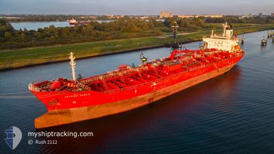
EASTERLY EAGLE
Oil/Chemical Tanker
Current Trip
| Time Travelled | 3 days |
|---|---|
| Remaining Time | --- |
| Distance Travelled | 655.01 nm |
| Remaining Distance | --- |
| AVG Speed | 12.4 Noeuds |
| MAX Speed | 15.4 Noeuds |
| AVG Wind | 8.5 knots |
| MAX Wind | 16 knots |
| MIN Temp | 26.1°C / 78.98°F |
| MAX Temp | 32.9°C / 91.22°F |
| Tirant d eau | 6.3 m |
| Position reçue | 14 h, 10 m depuis |
Current Position
| Longitude | 129.72353° |
|---|---|
| Latitude | 35.48780° |
| Etat | Under way using engine |
| Vitesse | 1.9 Noeuds |
| Parcours | 344° |
| Zone | Japan Sea |
| Station | T-AIS |
| Position reçue | 14 h, 10 m depuis |
Info
Information
The current position of EASTERLY EAGLE is in Japan Sea with coordinates 35.48780° / 129.72353° as reported on 2024-08-04 10:37 by AIS to our vessel tracker app. The vessel's current speed is 1.9 Noeuds
The vessel EASTERLY EAGLE (IMO: 9423750, MMSI: 538003924) is a Oil/Chemical Tanker that was built in 2010 ( 14 Age ). It's sailing under the flag of [MH] Marshall Is.
In this page you can find informations about the vessels current position, last detected port calls, and current voyage information. If the vessels is not in coverage by AIS you will find the latest position.
The current position of EASTERLY EAGLE is detected by our AIS receivers and we are not responsible for the reliability of the data. The last position was recorded while the vessel was in Coverage by the Ais receivers of our vessel tracking app.
The current draught of EASTERLY EAGLE as reported by AIS is 6.3 meters
Weather
| Temperature | 26.8°C / 80.24°F |
|---|---|
| Wind Speed | 8 knots |
| Direction | 33° NNE |
| Pressure | 1009.2 hPa |
| Humidity | 86.5 % |
| Cloud Coverage | 1 % |
Featured Company
Most Visited Ports (Last year)
| Port | Arrivals | |
|---|---|---|
| 5 | ||
| 3 | ||
| 2 | ||
| 2 | ||
| 2 | ||
| 2 |
Last Trips
| Origin | Departure | Destination | Arrival | Distance | |
|---|---|---|---|---|---|
| 2024-07-08 15:30 | 2024-07-29 18:58 | 6138.18 nm | |||
| 2024-07-02 06:04 | 2024-07-07 03:01 | 1239.62 nm | |||
| 2024-06-14 07:50 | 2024-06-30 11:33 | 3614.29 nm | |||
| 2024-06-09 23:11 | 2024-06-12 20:07 | 752.08 nm | |||
| 2024-05-20 14:57 | 2024-06-08 10:44 | 4923.57 nm |
Events
| Heure | Evenement | Détails | Position/ Destination | Info |
|---|---|---|---|---|
| 2024-08-04 14:35 | Arret | 3.32 nm, East of ONSAN |
35.43773 / 129.44463
ONSAN
|
Vitesse: 0.3 kn Parcours: 283° |
| 2024-08-04 10:39 | Etat Changé | Default Under way using engine |
35.48902 / 129.72378
ONSAN
|
Vitesse: 1.9 kn Parcours: 344° |
| 2024-08-04 10:37 | Hors de la zone couverte |
35.48780 / 129.72353
Japan Sea
|
Vitesse: 1.9 kn Parcours: 13.2° |
|
| 2024-08-04 10:27 | Etat Changé | Under way using engine Default |
35.48209 / 129.72262
ONSAN
|
Vitesse: 1.9 kn Parcours: 332° |
| 2024-08-04 10:20 | Etat Changé | Default Under way using engine |
35.47852 / 129.72235
ONSAN
|
Vitesse: 2 kn Parcours: 332° |
| 2024-08-04 10:08 | Etat Changé | Under way using engine Default |
35.47202 / 129.72209
ONSAN
|
Vitesse: 1.7 kn Parcours: 321° |
| 2024-08-04 09:39 | Etat Changé | Default Under way using engine |
35.45791 / 129.72136
ONSAN
|
Vitesse: 1.6 kn Parcours: 347° |
| 2024-08-04 07:48 | Etat Changé | Under way using engine Default |
35.50128 / 129.77760
ONSAN
|
Vitesse: 10.7 kn Parcours: 209° |
| 2024-08-04 07:44 | Etat Changé | Default Under way using engine |
35.51323 / 129.78615
ONSAN
|
Vitesse: 10.6 kn Parcours: 209.1° |
| 2024-08-04 07:38 | Etat Changé | Under way using engine Default |
35.52696 / 129.79574
ONSAN
|
Vitesse: 10.6 kn Parcours: 209° |