
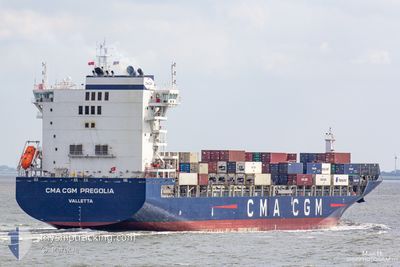
CMA CGM PREGOLIA
Cargo A
Current Trip
| Time Travelled | 3 days |
|---|---|
| Remaining Time | 1 day |
| Distance Travelled | 976.32 nm |
| Remaining Distance | 411.76 nm |
| AVG Speed | 13 Noeuds |
| MAX Speed | 14.3 Noeuds |
| AVG Wind | 16.2 knots |
| MAX Wind | 21 knots |
| MIN Temp | 15.9°C / 60.62°F |
| MAX Temp | 23.2°C / 73.76°F |
| Tirant d eau | 9.5 m |
| Position reçue | 2 d depuis |
Current Position
| Longitude | --- |
|---|---|
| Latitude | --- |
| Etat | Under way using engine |
| Vitesse | 13.2 Noeuds |
| Parcours | 344.8° |
| Zone | South Pacific Ocean |
| Station | T-AIS |
| Position reçue | 2 d depuis |
Info
Information
The current position of CMA CGM PREGOLIA is in South Pacific Ocean with coordinates -32.69698° / -72.13394° as reported on 2025-02-15 00:30 by AIS to our vessel tracker app. The vessel's current speed is 13.2 Noeuds and is heading at the port of CALLAO. The estimated time of arrival as calculated by MyShipTracking vessel tracking app is 2025-02-19 02:39 LT
The vessel CMA CGM PREGOLIA (IMO: 9745500, MMSI: 248659000) is a Cargo A It's sailing under the flag of [MT] Malta.
In this page you can find informations about the vessels current position, last detected port calls, and current voyage information. If the vessels is not in coverage by AIS you will find the latest position.
The current position of CMA CGM PREGOLIA is detected by our AIS receivers and we are not responsible for the reliability of the data. The last position was recorded while the vessel was in Coverage by the Ais receivers of our vessel tracking app.
The current draught of CMA CGM PREGOLIA as reported by AIS is 9.5 meters
Weather
| Temperature | 23.2°C / 73.76°F |
|---|---|
| Wind Speed | 16 knots |
| Direction | 156° SSE |
| Pressure | 1012.3 hPa |
| Humidity | 75.4 % |
| Cloud Coverage | 62 % |
Featured Company
Last Port Calls
| Port | Arrival | Departure | Time In Port |
|---|---|---|---|
| 2025-02-13 15:30 | 2025-02-14 19:19 | 1 d | |
| 2025-02-09 16:02 | 2025-02-10 01:54 | 9 h | |
| 2025-02-06 12:46 | 2025-02-07 13:49 | 1 d | |
| 2025-02-03 22:43 | 2025-02-04 08:34 | 9 h | |
| 2025-01-29 05:54 | 2025-01-29 23:48 | 17 h | |
| 2025-01-18 12:14 | 2025-01-18 13:26 | 1 h | |
| 2025-01-16 21:08 | 2025-01-17 15:21 | 18 h | |
| 2025-01-12 13:29 | 2025-01-13 03:24 | 13 h | |
| 2025-01-12 13:04 | 2025-01-12 13:19 | 14 m | |
| 2025-01-09 06:38 | 2025-01-09 18:02 | 11 h |
Most Visited Ports (Last year)
| Port | Arrivals | |
|---|---|---|
| 17 | ||
| 15 | ||
| 15 | ||
| 10 | ||
| 8 | ||
| 8 |
Last Trips
| Origin | Departure | Destination | Arrival | Distance | |
|---|---|---|---|---|---|
| 2025-02-09 20:54 | 2025-02-13 12:30 | 1340.53 nm | |||
| 2025-02-07 08:49 | 2025-02-09 11:02 | 717.64 nm | |||
| 2025-02-04 03:34 | 2025-02-06 07:46 | 594.32 nm | |||
| 2025-01-29 18:48 | 2025-02-03 17:43 | 686.75 nm | |||
| 2025-01-18 08:26 | 2025-01-29 00:54 | 1972.67 nm | |||
| 2025-01-17 10:21 | 2025-01-18 07:14 | 266.07 nm | |||
| 2025-01-12 22:24 | 2025-01-16 16:08 | 935.44 nm | |||
| 2025-01-12 08:19 | 2025-01-12 08:29 | 0.34 nm | |||
| 2025-01-09 13:02 | 2025-01-12 08:04 | 1149.57 nm | |||
| 2025-01-04 04:29 | 2025-01-09 01:38 | 1148.90 nm |
Events
| Heure | Evenement | Détails | Position/ Destination | Info |
|---|---|---|---|---|
| 2025-02-15 00:35 | Etat Changé | Default Under way using engine |
-32.68058 / -72.13898
PECLL
|
Vitesse: 13.2 kn Parcours: 344.8° |
| 2025-02-15 00:30 | Hors de la zone couverte |
-32.69698 / -72.13394
South Pacific Ocean
PECLL
|
Vitesse: 13.2 kn Parcours: 344.8° |
|
| 2025-02-15 00:12 | Tirant d'eau modifié | 9.5 10.2 |
-32.76147 / -72.11258
PECLL
|
Vitesse: 13 kn Parcours: 344.9° |
| 2025-02-15 00:12 | Changement de destination | PECLL CLSAI |
-32.76147 / -72.11258
PECLL
|
Vitesse: 13 kn Parcours: 344.9° |
| 2025-02-15 00:12 | Changement d'ETA | 2025/02/19 04:00 2025/02/13 16:00 |
-32.76147 / -72.11258
PECLL
|
Vitesse: 13 kn Parcours: 344.9° |
| 2025-02-14 23:28 | Etat Changé | Under way using engine Default |
-32.91593 / -72.06147
CLSAI
|
Vitesse: 13 kn Parcours: 350° |
| 2025-02-14 23:11 | Dans la zone couverte |
-32.91593 / -72.06147
South Pacific Ocean
|
Vitesse: 12.8 kn Parcours: 342.4° |
|
| 2025-02-14 19:19 | PORT DE DEPART |
|
-33.58412 / -71.63029
CLSAI
|
Vitesse: 3.8 kn Parcours: 270° |
| 2025-02-14 19:16 | Démarrage |
-33.58432 / -71.62586
[CL] SAN ANTONIO
|
Vitesse: 3.8 kn Parcours: 270° |
|
| 2025-02-13 15:42 | Arret |
-33.58892 / -71.61762
[CL] SAN ANTONIO
|
Vitesse: 0.2 kn Parcours: 188° |