

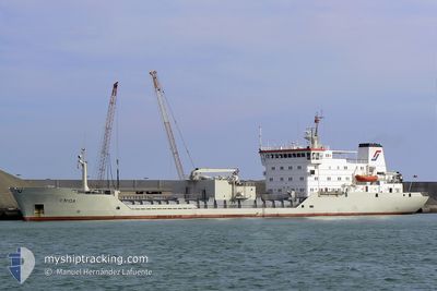
CEMENT FERRY
Cement Carrier

Current Trip
| Time Travelled | 4 h, 11 mins |
|---|---|
| Remaining Time | --- |
| Distance Travelled | 38.17 nm |
| Remaining Distance | --- |
| AVG Speed | 9.5 Noeuds |
| MAX Speed | 10 Noeuds |
| AVG Wind | 4.8 knots |
| MAX Wind | 6 knots |
| MIN Temp | 13°C / 55.4°F |
| MAX Temp | 14.4°C / 57.92°F |
| Tirant d eau | 7.3 m |
| Position reçue | 1 m depuis |
Current Position
| Longitude | --- |
|---|---|
| Latitude | --- |
| Etat | Under way using engine |
| Vitesse | 9.6 Noeuds |
| Parcours | 239.9° |
| Zone | Aegean Sea |
| Station | T-AIS |
| Position reçue | 1 m depuis |
Information
The current position of CEMENT FERRY is in Aegean Sea with coordinates 38.75246° / 26.14258° as reported on 2025-03-01 19:32 by AIS to our vessel tracker app. The vessel's current speed is 9.6 Noeuds
The vessel CEMENT FERRY (IMO: 8404264, MMSI: 305963000) is a Cement Carrier that was built in 1985 ( 40 Age ). It's sailing under the flag of [AG] Antigua Barbuda.
In this page you can find informations about the vessels current position, last detected port calls, and current voyage information. If the vessels is not in coverage by AIS you will find the latest position.
The current position of CEMENT FERRY is detected by our AIS receivers and we are not responsible for the reliability of the data. The last position was recorded while the vessel was in Coverage by the Ais receivers of our vessel tracking app.
The current draught of CEMENT FERRY as reported by AIS is 7.3 meters
Weather
| Temperature | 14.3°C / 57.74°F |
|---|---|
| Wind Speed | 6 knots |
| Direction | 327° NNW |
| Pressure | 1023.5 hPa |
| Humidity | 74.8 % |
| Cloud Coverage | 19 % |


Featured Company
Last Port Calls
| Port | Arrival | Departure | Time In Port |
|---|---|---|---|
| 2025-02-27 15:20 | 2025-03-01 18:23 | 2 d | |
| 2025-02-21 10:02 | 2025-02-23 16:03 | 2 d | |
| 2025-02-16 11:32 | 2025-02-18 15:43 | 2 d | |
| 2025-02-06 09:33 | 2025-02-08 08:30 | 1 d | |
| 2025-02-02 14:31 | |||
| 2025-01-26 07:28 | 2025-01-28 10:34 | 2 d | |
| 2025-01-21 11:48 |
Last Trips
| Origin | Departure | Destination | Arrival | Distance | |
|---|---|---|---|---|---|
| 2025-02-23 16:03 | 2025-02-27 15:20 | 644.04 nm | |||
| 2025-02-18 15:43 | 2025-02-21 10:02 | 653.96 nm | |||
| 2025-02-08 08:30 | 2025-02-16 11:32 | 1287.39 nm | |||
| 2025-02-02 14:31 | 2025-02-06 09:33 | 644.83 nm | |||
| 2025-01-21 11:48 | 2025-01-26 07:28 | 285.77 nm |
Events
| Heure | Evenement | Détails | Position/ Destination | Info |
|---|---|---|---|---|
| 2025-03-01 19:13 | Tirant d'eau modifié | 7.3 4.2 |
38.77807 / 26.19900
AL ROM
|
Vitesse: 9.5 kn Parcours: 239.5° |
| 2025-03-01 19:13 | Changement de destination | AL ROM TR DIK |
38.77807 / 26.19900
AL ROM
|
Vitesse: 9.5 kn Parcours: 239.5° |
| 2025-03-01 19:13 | Changement d'ETA | 2025/03/04 09:00 2025/02/26 09:00 |
38.77807 / 26.19900
AL ROM
|
Vitesse: 9.5 kn Parcours: 239.5° |
| 2025-03-01 19:11 | Etat Changé | Under way using engine Default |
38.78005 / 26.20338
TR DIK
|
Vitesse: 9.3 kn Parcours: 240° |
| 2025-03-01 19:11 | Dans la zone couverte |
38.77674 / 26.19605
Aegean Sea
AL ROM
|
Vitesse: 9.5 kn Parcours: 239.8° |
|
| 2025-03-01 15:30 | Démarrage | 1.25 nm, West of DIKILI |
39.07264 / 26.85782
TR DIK
|
Vitesse: 8.9 kn Parcours: 272° |
| 2025-03-01 15:23 | PORT DE DEPART |
|
39.07264 / 26.85782
TR DIK
|
Vitesse: 2 kn Parcours: 136° |
| 2025-02-27 12:20 | Port d'arrivée |
|
39.07120 / 26.88511
[TR] DIKILI
|
Vitesse: 2.3 kn Parcours: 133° |
| 2025-02-26 06:35 | Arret | 1.11 nm, North West of DIKILI |
39.08261 / 26.86693
TR DIK
|
Vitesse: 0.2 kn Parcours: 140° |
| 2025-02-26 01:18 | Hors de la zone couverte |
38.75223 / 26.14684
Aegean Sea
TR DIK
|
Vitesse: 9.1 kn Parcours: 59.2° |