

BRUSSELS
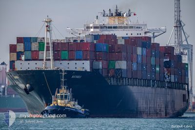
Container Ship

Current Trip
| Time Travelled | 15 days |
|---|---|
| Remaining Time | --- |
| Distance Travelled | 5453.32 nm |
| Remaining Distance | --- |
| AVG Speed | 16.8 Noeuds |
| MAX Speed | 20.5 Noeuds |
| AVG Wind | 12.8 knots |
| MAX Wind | 33 knots |
| MIN Temp | 3.5°C / 38.3°F |
| MAX Temp | 26.1°C / 78.98°F |
| Tirant d eau | 12.9 m |
| Position reçue | 2 d depuis |
Current Position
| Longitude | --- |
|---|---|
| Latitude | --- |
| Etat | Under way using engine |
| Vitesse | 17.6 Noeuds |
| Parcours | 259.6° |
| Zone | North Atlantic Ocean |
| Station | T-AIS |
| Position reçue | 2 d depuis |
Information
The current position of BRUSSELS is in North Atlantic Ocean with coordinates 23.41756° / -82.60014° as reported on 2025-03-25 01:44 by AIS to our vessel tracker app. The vessel's current speed is 17.6 Noeuds
The vessel BRUSSELS (IMO: 9200691, MMSI: 255806004) is a Container Ship that was built in 2000 ( 25 Age ). It's sailing under the flag of [PT] Portugal.
In this page you can find informations about the vessels current position, last detected port calls, and current voyage information. If the vessels is not in coverage by AIS you will find the latest position.
The current position of BRUSSELS is detected by our AIS receivers and we are not responsible for the reliability of the data. The last position was recorded while the vessel was in Coverage by the Ais receivers of our vessel tracking app.
The current draught of BRUSSELS as reported by AIS is 12.9 meters
Weather
| Temperature | 25.4°C / 77.72°F |
|---|---|
| Wind Speed | 13 knots |
| Direction | 94° E |
| Pressure | 1010.6 hPa |
| Humidity | 84.1 % |
| Cloud Coverage | 10 % |


Featured Company
Last Port Calls
| Port | Arrival | Departure | Time In Port |
|---|---|---|---|
| 2025-03-10 21:10 | 2025-03-12 13:38 | 1 d | |
| 2025-03-07 20:46 | 2025-03-09 17:50 | 1 d | |
| 2025-03-05 05:41 | 2025-03-06 08:24 | 1 d | |
| 2025-03-01 21:18 | 2025-03-02 14:10 | 16 h | |
| 2025-02-15 18:55 | 2025-02-16 14:55 | 19 h | |
| 2025-02-11 19:19 | 2025-02-14 13:28 | 2 d | |
| 2025-02-06 11:58 | 2025-02-07 04:47 | 16 h | |
| 2025-01-29 10:45 | 2025-01-30 01:29 | 14 h | |
| 2025-01-27 03:36 | 2025-01-28 00:43 | 21 h | |
| 2025-01-13 21:20 | 2025-01-14 23:34 | 1 d |
Most Visited Ports (Last year)
| Port | Arrivals | |
|---|---|---|
| 7 | ||
| 7 | ||
| 7 | ||
| 6 | ||
| 6 | ||
| 6 |
Last Trips
| Origin | Departure | Destination | Arrival | Distance | |
|---|---|---|---|---|---|
| 2025-03-09 17:50 | 2025-03-10 21:10 | 370.06 nm | |||
| 2025-03-06 08:24 | 2025-03-07 20:46 | 132.74 nm | |||
| 2025-03-02 14:10 | 2025-03-05 05:41 | 282.96 nm | |||
| 2025-02-16 14:55 | 2025-03-01 21:18 | 4909.46 nm | |||
| 2025-02-14 13:28 | 2025-02-15 18:55 | 440.81 nm | |||
| 2025-02-07 04:47 | 2025-02-11 19:19 | 510.39 nm | |||
| 2025-01-30 01:29 | 2025-02-06 11:58 | 1492.25 nm | |||
| 2025-01-28 00:43 | 2025-01-29 10:45 | 433.08 nm | |||
| 2025-01-14 23:34 | 2025-01-27 03:36 | 4981.57 nm | |||
| 2025-01-12 23:26 | 2025-01-13 21:20 | 278.69 nm |
Events
| Heure | Evenement | Détails | Position/ Destination | Info |
|---|---|---|---|---|
| 2025-03-27 16:16 | Arret | 15.19 nm, North of VERACRUZ |
19.45415 / -96.08601
DEBRV>>MXVER
|
Vitesse: 0.1 kn Parcours: 121° |
| 2025-03-25 01:53 | Etat Changé | Default Under way using engine |
23.41059 / -82.64398
DEBRV>>MXVER
|
Vitesse: 17.6 kn Parcours: 259.6° |
| 2025-03-25 01:44 | Hors de la zone couverte |
23.41756 / -82.60014
North Atlantic Ocean
DEBRV>>MXVER
|
Vitesse: 17.6 kn Parcours: 259.6° |
|
| 2025-03-25 01:13 | Etat Changé | Under way using engine Default |
23.44447 / -82.43614
DEBRV>>MXVER
|
Vitesse: 17.6 kn Parcours: 260° |
| 2025-03-25 00:59 | Etat Changé | Default Under way using engine |
23.45637 / -82.36460
DEBRV>>MXVER
|
Vitesse: 17.6 kn Parcours: 260.6° |
| 2025-03-24 23:37 | Etat Changé | Under way using engine Default |
23.51975 / -81.93758
DEBRV>>MXVER
|
Vitesse: 17 kn Parcours: 257° |
| 2025-03-24 23:28 | Etat Changé | Default Under way using engine |
23.52924 / -81.88808
DEBRV>>MXVER
|
Vitesse: 17 kn Parcours: 257.3° |
| 2025-03-24 20:44 | Changement de zone | Cuban part of the North Atlantic Ocean Bahamas part of the North Atlantic Ocean |
23.77795 / -81.08552
North Atlantic Ocean
DEBRV>>MXVER
|
Vitesse: 17.4 kn Parcours: 225.6° |
| 2025-03-24 20:35 | Etat Changé | Under way using engine Default |
23.80420 / -81.04982
DEBRV>>MXVER
|
Vitesse: 17.5 kn Parcours: 237° |
| 2025-03-24 19:42 | Etat Changé | Default Under way using engine |
23.94321 / -80.81545
DEBRV>>MXVER
|
Vitesse: 17.5 kn Parcours: 237.6° |