
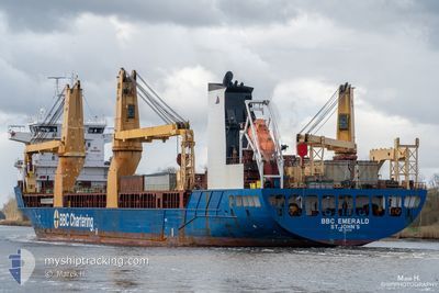
BBC EMERALD
General Cargo
Current Trip
LAST UPDATE TIME
| Time Travelled | 23 days |
|---|---|
| Remaining Time | --- |
| Distance Travelled | 7387.27 nm |
| Remaining Distance | --- |
| AVG Speed | 14.4 Noeuds |
| MAX Speed | 18 Noeuds |
| AVG Wind | 11 knots |
| MAX Wind | 33 knots |
| MIN Temp | 4.8°C / 40.64°F |
| MAX Temp | 30.1°C / 86.18°F |
| Tirant d eau | 8.6 m |
| Position reçue | 7 d depuis |
Current Position
| Longitude | -72.41330° |
|---|---|
| Latitude | 22.21500° |
| Etat | Under way using engine |
| Vitesse | 14 Noeuds |
| Parcours | 42° |
| Zone | North Atlantic Ocean |
| Station | T-AIS |
| Position reçue | 7 d depuis |
Info
Information
The current position of BBC EMERALD is in North Atlantic Ocean with coordinates 22.21500° / -72.41330° as reported on 2024-05-02 22:21 by AIS to our vessel tracker app. The vessel's current speed is 14 Noeuds
The vessel BBC EMERALD (IMO: 9504750, MMSI: 305857000) is a General Cargo that was built in 2013 ( 11 Age ). It's sailing under the flag of [AG] Antigua Barbuda.
In this page you can find informations about the vessels current position, last detected port calls, and current voyage information. If the vessels is not in coverage by AIS you will find the latest position.
The current position of BBC EMERALD is detected by our AIS receivers and we are not responsible for the reliability of the data. The last position was recorded while the vessel was in Coverage by the Ais receivers of our vessel tracking app.
The current draught of BBC EMERALD as reported by AIS is 8.6 meters
Weather
| Temperature | 13.8°C / 56.84°F |
|---|---|
| Wind Speed | 13 knots |
| Direction | 260° W |
| Pressure | 1011.6 hPa |
| Humidity | 69.5 % |
| Cloud Coverage | 100 % |
Featured Company
Most Visited Ports (Last year)
| Port | Arrivals | |
|---|---|---|
| 3 | ||
| 2 | ||
| 1 | ||
| 1 | ||
| 1 | ||
| 1 |
Events
| Heure | Evenement | Détails | Position/ Destination | Info |
|---|---|---|---|---|
| 2024-05-02 22:33 | Etat Changé | Default Under way using engine |
22.25833 / -72.36833
LAST UPDATE TIME
|
Vitesse: 14 kn Parcours: 42° |
| 2024-05-02 22:21 | Changement d'ETA | 2024/05/02 22:18 2024/05/02 21:57 |
22.21500 / -72.41330
LAST UPDATE TIME
|
Vitesse: 14 kn Parcours: 42° |
| 2024-05-02 22:21 | Etat Changé | Under way using engine Default |
22.21500 / -72.41330
LAST UPDATE TIME
|
Vitesse: 15 kn Parcours: 46° |
| 2024-05-02 22:21 | Hors de la zone couverte |
22.21500 / -72.41330
North Atlantic Ocean
LAST UPDATE TIME
|
Vitesse: 14 kn Parcours: 42° |
|
| 2024-05-02 22:12 | Etat Changé | Default Under way using engine |
22.19833 / -72.43166
LAST UPDATE TIME
|
Vitesse: 15 kn Parcours: 46° |
| 2024-05-02 21:59 | Changement d'ETA | 2024/05/02 21:57 2024/05/02 21:54 |
22.13830 / -72.49670
LAST UPDATE TIME
|
Vitesse: 15 kn Parcours: 46° |
| 2024-05-02 21:58 | Changement d'ETA | 2024/05/02 21:54 2024/05/02 21:51 |
22.13830 / -72.49670
LAST UPDATE TIME
|
Vitesse: 15 kn Parcours: 46° |
| 2024-05-02 21:54 | Changement d'ETA | 2024/05/02 21:51 2024/05/02 21:50 |
22.11830 / -72.51330
LAST UPDATE TIME
|
Vitesse: 15 kn Parcours: 16° |
| 2024-05-02 21:52 | Changement d'ETA | 2024/05/02 21:50 2024/05/02 21:42 |
22.11830 / -72.51330
LAST UPDATE TIME
|
Vitesse: 15 kn Parcours: 16° |
| 2024-05-02 21:45 | Detecté en mer | Bahamas part of the North Atlantic Ocean |
22.10670 / -72.51670
North Atlantic Ocean
LAST UPDATE TIME
|
Vitesse: 14 kn Parcours: 14° |