

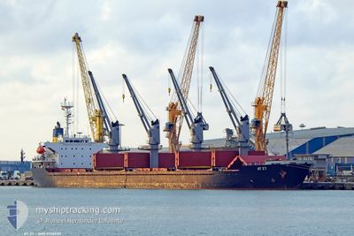
AT 27
Bulk Carrier

Current Trip
ORDER
| Time Travelled | 8 days |
|---|---|
| Remaining Time | --- |
| Distance Travelled | 71.57 nm |
| Remaining Distance | --- |
| AVG Speed | 10.6 Noeuds |
| MAX Speed | 12.8 Noeuds |
| AVG Wind | 8.3 knots |
| MAX Wind | 16.8 knots |
| MIN Temp | 3.3°C / 37.94°F |
| MAX Temp | 10.4°C / 50.72°F |
| Tirant d eau | 5.8 m |
| Position reçue | 8 d depuis |
Current Position
| Longitude | --- |
|---|---|
| Latitude | --- |
| Etat | Under way using engine |
| Vitesse | 11.6 Noeuds |
| Parcours | 78.9° |
| Zone | Black Sea |
| Station | T-AIS |
| Position reçue | 8 d depuis |
Information
The current position of AT 27 is in Black Sea with coordinates 44.32034° / 28.80798° as reported on 2025-03-01 11:45 by AIS to our vessel tracker app. The vessel's current speed is 11.6 Noeuds
The vessel AT 27 (IMO: 9136539, MMSI: 511100611) is a Bulk Carrier that was built in 1997 ( 28 Age ). It's sailing under the flag of [PW] Palau.
In this page you can find informations about the vessels current position, last detected port calls, and current voyage information. If the vessels is not in coverage by AIS you will find the latest position.
The current position of AT 27 is detected by our AIS receivers and we are not responsible for the reliability of the data. The last position was recorded while the vessel was in Coverage by the Ais receivers of our vessel tracking app.
The current draught of AT 27 as reported by AIS is 5.8 meters
Weather
| Temperature | 8.4°C / 47.12°F |
|---|---|
| Wind Speed | 7 knots |
| Direction | 195° SSW |
| Pressure | 1014.3 hPa |
| Humidity | 82.2 % |
| Cloud Coverage | 100 % |


Featured Company
Most Visited Ports (Last year)
| Port | Arrivals | |
|---|---|---|
| 3 | ||
| 2 | ||
| 2 | ||
| 1 | ||
| 1 | ||
| 1 |
Events
| Heure | Evenement | Détails | Position/ Destination | Info |
|---|---|---|---|---|
| 2025-03-07 23:26 | Arret | 15.07 nm, South East of SFANTU GHEORGHE |
44.78313 / 29.90608
ORDER
|
Vitesse: 0.3 kn Parcours: 60° |
| 2025-03-07 19:11 | Démarrage | 19.07 nm, East of MIDIA |
44.32248 / 29.10947
ORDER
|
Vitesse: 3.5 kn Parcours: 37° |
| 2025-03-01 13:14 | Arret | 19.05 nm, East of MIDIA |
44.32423 / 29.10906
ORDER
|
Vitesse: 0.1 kn Parcours: 143° |
| 2025-03-01 11:54 | Etat Changé | Default Under way using engine |
44.32173 / 28.84578
ORDER
|
Vitesse: 11.6 kn Parcours: 78.9° |
| 2025-03-01 11:45 | Hors de la zone couverte |
44.32034 / 28.80798
Black Sea
|
Vitesse: 11.6 kn Parcours: 78.9° |
|
| 2025-03-01 11:43 | Etat Changé | Under way using engine Default |
44.31909 / 28.79912
ORDER
|
Vitesse: 11.6 kn Parcours: 78° |
| 2025-03-01 11:42 | Etat Changé | Default Under way using engine |
44.31817 / 28.79247
ORDER
|
Vitesse: 11.4 kn Parcours: 87° |
| 2025-03-01 11:27 | Etat Changé | Under way using engine Moored |
44.31179 / 28.72790
ORDER
|
Vitesse: 10.1 kn Parcours: 87.1° |
| 2025-03-01 11:25 | Tirant d'eau modifié | 5.8 8.1 |
44.31124 / 28.71427
ORDER
|
Vitesse: 10.1 kn Parcours: 87.1° |
| 2025-03-01 11:25 | Changement de destination | ORDER RO/MID |
44.31124 / 28.71427
ORDER
|
Vitesse: 10.1 kn Parcours: 87.1° |