
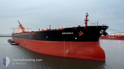
ARAGONA
Tanker
Current Trip
| Time Travelled | 12 days |
|---|---|
| Remaining Time | --- |
| Distance Travelled | 2994.52 nm |
| Remaining Distance | --- |
| AVG Speed | 10.8 Noeuds |
| MAX Speed | 14.2 Noeuds |
| AVG Wind | 15.1 knots |
| MAX Wind | 24 knots |
| MIN Temp | 26.6°C / 79.88°F |
| MAX Temp | 29.6°C / 85.28°F |
| Tirant d eau | 14.5 m |
| Position reçue | 2 d depuis |
Current Position
| Longitude | -61.10785° |
|---|---|
| Latitude | 13.47483° |
| Etat | Under way using engine |
| Vitesse | 10.6 Noeuds |
| Parcours | 102.1° |
| Zone | Caribbean Sea |
| Station | T-AIS |
| Position reçue | 2 d depuis |
Info
Information
The current position of ARAGONA is in Caribbean Sea with coordinates 13.47483° / -61.10785° as reported on 2024-06-02 17:07 by AIS to our vessel tracker app. The vessel's current speed is 10.6 Noeuds and is heading at the port of KAOHSIUNG. The estimated time of arrival as calculated by MyShipTracking vessel tracking app is 2024-07-14 23:00 LT
The vessel ARAGONA (IMO: 9513115, MMSI: 241162000) is a Tanker It's sailing under the flag of [GR] Greece.
In this page you can find informations about the vessels current position, last detected port calls, and current voyage information. If the vessels is not in coverage by AIS you will find the latest position.
The current position of ARAGONA is detected by our AIS receivers and we are not responsible for the reliability of the data. The last position was recorded while the vessel was in Coverage by the Ais receivers of our vessel tracking app.
The current draught of ARAGONA as reported by AIS is 14.5 meters
Weather
| Temperature | 28°C / 82.4°F |
|---|---|
| Wind Speed | 15 knots |
| Direction | 66° ENE |
| Pressure | 1012.6 hPa |
| Humidity | 80.1 % |
| Cloud Coverage | 100 % |
Featured Company
Events
| Heure | Evenement | Détails | Position/ Destination | Info |
|---|---|---|---|---|
| 2024-06-02 17:08 | Etat Changé | Default Under way using engine |
13.47432 / -61.10543
KAOHSIUNG
|
Vitesse: 10.6 kn Parcours: 102.1° |
| 2024-06-02 17:07 | Hors de la zone couverte |
13.47483 / -61.10785
Caribbean Sea
|
Vitesse: 10.6 kn Parcours: 102.1° |
|
| 2024-06-02 17:01 | Etat Changé | Under way using engine Default |
13.47828 / -61.12690
KAOHSIUNG
|
Vitesse: 10.5 kn Parcours: 103° |
| 2024-06-02 17:00 | Etat Changé | Default Under way using engine |
13.47885 / -61.12988
KAOHSIUNG
|
Vitesse: 10.6 kn Parcours: 93.1° |
| 2024-06-02 15:43 | Changement de zone | Saint Vincent and the Grenadines part of the Caribbean Sea United States part of the Gulf of Mexico |
13.51907 / -61.37877
Caribbean Sea
|
Vitesse: 12.2 kn Parcours: 101.6° |
| 2024-06-02 15:43 | Etat Changé | Under way using engine Default |
13.51907 / -61.37877
KAOHSIUNG
|
Vitesse: 12 kn Parcours: 100° |
| 2024-06-02 15:32 | Dans la zone couverte |
13.51907 / -61.37877
Caribbean Sea
|
Vitesse: 12.2 kn Parcours: 101.6° |
|
| 2024-05-25 21:54 | Etat Changé | Default Under way using engine |
28.35231 / -94.49371
KAOHSIUNG
|
Vitesse: 9.7 kn Parcours: 139.8° |
| 2024-05-25 21:48 | Hors de la zone couverte |
28.36490 / -94.50622
Gulf of Mexico
|
Vitesse: 9.7 kn Parcours: 139.8° |