
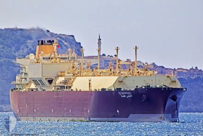
AL GHARRAFA
Lng Tanker
Current Trip
| Time Travelled | --- |
|---|---|
| Remaining Time | --- |
| Distance Travelled | 14180.28 nm |
| Remaining Distance | --- |
| AVG Speed | 13.8 Noeuds |
| MAX Speed | 19 Noeuds |
| AVG Wind | 19.3 knots |
| MAX Wind | 41 knots |
| MIN Temp | 5°C / 41°F |
| MAX Temp | 28.6°C / 83.48°F |
| Tirant d eau | 9.9 m |
| Position reçue | 4 d depuis |
Current Position
| Longitude | --- |
|---|---|
| Latitude | --- |
| Etat | Under way using engine |
| Vitesse | 15 Noeuds |
| Parcours | 101.1° |
| Zone | South Atlantic Ocean |
| Station | T-AIS |
| Position reçue | 4 d depuis |
Info
Information
The current position of AL GHARRAFA is in South Atlantic Ocean with coordinates -34.96911° / 19.13743° as reported on 2025-01-09 02:07 by AIS to our vessel tracker app. The vessel's current speed is 15 Noeuds and is heading at the port of RAS LAFFAN. The estimated time of arrival as calculated by MyShipTracking vessel tracking app is 2025-01-22 06:00 LT
The vessel AL GHARRAFA (IMO: 9337717, MMSI: 538002920) is a Lng Tanker that was built in 2008 ( 17 Age ). It's sailing under the flag of [MH] Marshall Is.
In this page you can find informations about the vessels current position, last detected port calls, and current voyage information. If the vessels is not in coverage by AIS you will find the latest position.
The current position of AL GHARRAFA is detected by our AIS receivers and we are not responsible for the reliability of the data. The last position was recorded while the vessel was in Coverage by the Ais receivers of our vessel tracking app.
The current draught of AL GHARRAFA as reported by AIS is 9.9 meters
Weather
| Temperature | 27.6°C / 81.68°F |
|---|---|
| Wind Speed | 20 knots |
| Direction | 34° NE |
| Pressure | 1009.4 hPa |
| Humidity | 82.5 % |
| Cloud Coverage | --- |
Featured Company
Last Port Calls
| Port | Arrival | Departure | Time In Port |
|---|---|---|---|
| 2024-11-10 23:38 | 2024-11-12 01:57 | 1 d |
Most Visited Ports (Last year)
| Port | Arrivals | |
|---|---|---|
| 6 | ||
| 2 | ||
| 1 | ||
| 1 |
Last Trips
| Origin | Departure | Destination | Arrival | Distance | |
|---|---|---|---|---|---|
| 2024-10-22 15:34 | 2024-11-11 02:38 | 5210.09 nm |
Events
| Heure | Evenement | Détails | Position/ Destination | Info |
|---|---|---|---|---|
| 2025-01-09 02:08 | Etat Changé | Default Under way using engine |
-34.96953 / 19.13965
DK SKA>QA RLF
|
Vitesse: 15 kn Parcours: 101.1° |
| 2025-01-09 02:07 | Etat Changé | Under way using engine Default |
-34.96911 / 19.13743
DK SKA>QA RLF
|
Vitesse: 15.3 kn Parcours: 115° |
| 2025-01-09 02:07 | Hors de la zone couverte |
-34.96911 / 19.13743
South Atlantic Ocean
DK SKA>QA RLF
|
Vitesse: 15 kn Parcours: 101.1° |
|
| 2025-01-09 02:03 | Dans la zone couverte |
-34.96911 / 19.13743
South Atlantic Ocean
DK SKA>QA RLF
|
Vitesse: 15 kn Parcours: 101.1° |
|
| 2025-01-09 00:07 | Etat Changé | Default Under way using engine |
-34.75917 / 18.57793
DK SKA>QA RLF
|
Vitesse: 15 kn Parcours: 108.8° |
| 2025-01-09 00:07 | Hors de la zone couverte |
-34.75892 / 18.57713
South Atlantic Ocean
DK SKA>QA RLF
|
Vitesse: 15 kn Parcours: 108.8° |
|
| 2025-01-08 22:09 | Etat Changé | Under way using engine Default |
-34.59391 / 18.03927
DK SKA>QA RLF
|
Vitesse: 14 kn Parcours: 133° |
| 2025-01-08 22:08 | Etat Changé | Default Under way using engine |
-34.58997 / 18.03383
DK SKA>QA RLF
|
Vitesse: 13.7 kn Parcours: 130.3° |
| 2025-01-08 21:59 | Changement de zone | South African part of the South Atlantic Ocean Spanish (Canary Islands) part of the North Atlantic Ocean |
-34.57057 / 18.00507
South Atlantic Ocean
DK SKA>QA RLF
|
Vitesse: 13.7 kn Parcours: 130.3° |
| 2025-01-08 21:59 | Etat Changé | Under way using engine Default |
-34.56978 / 18.00387
DK SKA>QA RLF
|
Vitesse: 14 kn Parcours: 130° |