
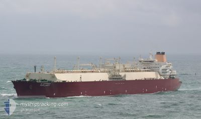
AL GHARRAFA
Lng Tanker
Current Trip
| Time Travelled | 20 days |
|---|---|
| Remaining Time | --- |
| Distance Travelled | 7741.59 nm |
| Remaining Distance | --- |
| AVG Speed | 15.8 Knots |
| MAX Speed | 19.3 Knots |
| AVG Wind | 11.1 knots |
| MAX Wind | 28 knots |
| MIN Temp | 15.5°C / 59.9°F |
| MAX Temp | 30.1°C / 86.18°F |
| Dybgang | 12.2 m |
| Position Modtaget | 6 d siden |
Current Position
| Longitude | 18.22386° |
|---|---|
| Latitude | -33.86566° |
| Status | Under way using engine |
| Fart | 8.5 Knots |
| Kurs | 311.4° |
| Område | South Atlantic Ocean |
| Station | T-AIS |
| Position Modtaget | 6 d siden |
Info
Information
The current position of AL GHARRAFA is in South Atlantic Ocean with coordinates -33.86566° / 18.22386° as reported on 2024-05-17 04:59 by AIS to our vessel tracker app. The vessel's current speed is 8.5 Knots and is heading at the port of FOS. The estimated time of arrival as calculated by MyShipTracking vessel tracking app is 2024-06-05 04:00 LT
The vessel AL GHARRAFA (IMO: 9337717, MMSI: 538002920) is a Lng Tanker that was built in 2008 ( 16 år gamle ). It's sailing under the flag of [MH] Marshall Is.
In this page you can find informations about the vessels current position, last detected port calls, and current voyage information. If the vessels is not in coverage by AIS you will find the latest position.
The current position of AL GHARRAFA is detected by our AIS receivers and we are not responsible for the reliability of the data. The last position was recorded while the vessel was in Coverage by the Ais receivers of our vessel tracking app.
The current draught of AL GHARRAFA as reported by AIS is 12.2 meters
Weather
| Temperature | 26.6°C / 79.88°F |
|---|---|
| Wind Speed | 8 knots |
| Direction | 128° SE |
| Pressure | 1013.8 hPa |
| Humidity | 77.5 % |
| Cloud Coverage | 100 % |
Featured Company
Last Port Calls
| Port | Arrival | Departure | Time In Port |
|---|---|---|---|
| 2024-05-02 00:03 | 2024-05-03 10:23 | 1 d |
Most Visited Ports (Last year)
| Port | Arrivals | |
|---|---|---|
| 9 | ||
| 4 | ||
| 2 | ||
| 1 | ||
| 1 | ||
| 1 |
Last Trips
| Origin | Departure | Destination | Arrival | Distance | |
|---|---|---|---|---|---|
| 2024-02-14 12:19 | 2024-05-02 03:03 | 10394.77 nm |
Events
| Tid | Hændelsen | Detaljer | Position / Dest | Info |
|---|---|---|---|---|
| 2024-05-17 05:08 | Status er ændret | Default Under way using engine |
-33.85146 / 18.20428
FR FOS
|
Fart: 8.5 kn Kurs: 311.4° |
| 2024-05-17 04:59 | Status er ændret | Under way using engine Default |
-33.86566 / 18.22386
FR FOS
|
Fart: 7.3 kn Kurs: 320° |
| 2024-05-17 04:59 | Udenfor Dækning |
-33.86566 / 18.22386
South Atlantic Ocean
FR FOS
|
Fart: 8.5 kn Kurs: 311.4° |
|
| 2024-05-17 04:56 | Status er ændret | Default Under way using engine |
-33.87113 / 18.23128
FR FOS
|
Fart: 5.4 kn Kurs: 359.6° |
| 2024-05-17 04:45 | Status er ændret | Under way using engine Default |
-33.88645 / 18.23489
FR FOS
|
Fart: 4.5 kn Kurs: 20° |
| 2024-05-17 04:15 | Status er ændret | Default Under way using engine |
-33.93652 / 18.20241
FR FOS
|
Fart: 15.4 kn Kurs: 31.6° |
| 2024-05-17 04:00 | Status er ændret | Under way using engine Default |
-33.99289 / 18.16173
FR FOS
|
Fart: 15.9 kn Kurs: 30° |
| 2024-05-17 03:51 | Status er ændret | Default Under way using engine |
-34.02833 / 18.13833
FR FOS
|
Fart: 15.8 kn Kurs: 25.8° |
| 2024-05-17 03:24 | Status er ændret | Under way using engine Default |
-34.13870 / 18.09238
FR FOS
|
Fart: 15.9 kn Kurs: 358° |
| 2024-05-17 03:18 | Status er ændret | Default Under way using engine |
-34.16667 / 18.09333
FR FOS
|
Fart: 16.5 kn Kurs: 356.1° |