
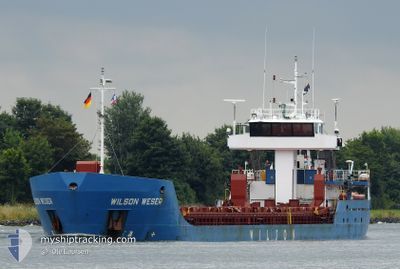
WILSON WESER
General Cargo
Current Trip
| Time Travelled | 7 days |
|---|---|
| Remaining Time | 1 day |
| Distance Travelled | 1233.28 nm |
| Remaining Distance | 410.79 nm |
| AVG Speed | 10.3 Knots |
| MAX Speed | 13.6 Knots |
| AVG Wind | 14.1 knots |
| MAX Wind | 32 knots |
| MIN Temp | 7.3°C / 45.14°F |
| MAX Temp | 24.5°C / 76.1°F |
| Dybgang | 4.6 m |
| Position Modtaget | Nu |
Current Position
| Longitude | 7.02867° |
|---|---|
| Latitude | 63.38391° |
| Status | Under way using engine |
| Fart | 11.7 Knots |
| Kurs | 42.2° |
| Område | Norwegian Sea |
| Station | T-AIS |
| Position Modtaget | Nu |
Info
Information
The current position of WILSON WESER is in Norwegian Sea with coordinates 63.38391° / 7.02867° as reported on 2024-05-08 22:36 by AIS to our vessel tracker app. The vessel's current speed is 11.7 Knots and is heading at the port of STOKMARKNES. The estimated time of arrival as calculated by MyShipTracking vessel tracking app is 2024-05-10 10:08 LT
The vessel WILSON WESER (IMO: 9198446, MMSI: 314020000) is a General Cargo that was built in 2005 ( 19 år gamle ). It's sailing under the flag of [BB] Barbados.
In this page you can find informations about the vessels current position, last detected port calls, and current voyage information. If the vessels is not in coverage by AIS you will find the latest position.
The current position of WILSON WESER is detected by our AIS receivers and we are not responsible for the reliability of the data. The last position was recorded while the vessel was in Coverage by the Ais receivers of our vessel tracking app.
The current draught of WILSON WESER as reported by AIS is 4.6 meters
Weather
| Temperature | 7.8°C / 46.04°F |
|---|---|
| Wind Speed | 17 knots |
| Direction | 215° SW |
| Pressure | 1019.7 hPa |
| Humidity | 79 % |
| Cloud Coverage | 100 % |
Featured Company
Last Port Calls
| Port | Arrival | Departure | Time In Port |
|---|---|---|---|
| 2024-04-30 19:51 | 2024-05-01 15:54 | 20 h | |
| 2024-04-27 07:06 | 2024-04-29 21:12 | 2 d | |
| 2024-04-25 04:53 | 2024-04-25 15:10 | 10 h | |
| 2024-04-24 11:29 | 2024-04-25 04:16 | 16 h | |
| 2024-04-05 15:13 | 2024-04-09 06:12 | 3 d | |
| 2024-03-26 07:09 | 2024-03-27 12:15 | 1 d | |
| 2024-03-25 05:07 | 2024-03-25 11:53 | 6 h | |
| 2024-03-21 01:56 | 2024-03-21 19:10 | 17 h | |
| 2024-03-18 06:51 | 2024-03-20 00:19 | 1 d | |
| 2024-03-15 12:08 | 2024-03-16 15:03 | 1 d |
Last Trips
| Origin | Departure | Destination | Arrival | Distance | |
|---|---|---|---|---|---|
| 2024-04-29 22:12 | 2024-04-30 21:51 | 216.52 nm | |||
| 2024-04-25 17:10 | 2024-04-27 08:06 | 304.23 nm | |||
| 2024-04-25 06:16 | 2024-04-25 06:53 | 1.67 nm | |||
| 2024-04-09 07:12 | 2024-04-24 13:29 | 1898.76 nm | |||
| 2024-03-27 13:15 | 2024-04-05 16:13 | 979.06 nm | |||
| 2024-03-25 12:53 | 2024-03-26 08:09 | 214.32 nm | |||
| 2024-03-21 20:10 | 2024-03-25 06:07 | 522.57 nm | |||
| 2024-03-20 00:19 | 2024-03-21 02:56 | 283.23 nm | |||
| 2024-03-16 16:03 | 2024-03-18 06:51 | 274.55 nm | |||
| 2024-03-14 11:51 | 2024-03-15 13:08 | 265.55 nm |
Events
| Tid | Hændelsen | Detaljer | Position / Dest | Info |
|---|---|---|---|---|
| 2024-05-08 08:04 | Ændre havområde | Norwegian part of the Norwegian Sea Norwegian part of the North Sea |
61.00415 / 4.39895
Norwegian Sea
STOKMARKNES
|
Fart: 12.3 kn Kurs: 355.3° |
| 2024-05-07 16:39 | Dybgangen er ændret | 4.6 2.7 |
58.42786 / 5.99043
STOKMARKNES
|
Fart: 8.5 kn Kurs: 171.6° |
| 2024-05-07 16:39 | Destination er ændret | STOKMARKNES NOEGD |
58.42786 / 5.99043
STOKMARKNES
|
Fart: 8.5 kn Kurs: 171.6° |
| 2024-05-07 16:39 | ETA er ændret | 2024/05/10 14:00 2024/05/07 00:00 |
58.42786 / 5.99043
STOKMARKNES
|
Fart: 8.5 kn Kurs: 171.6° |
| 2024-05-07 16:37 | START Sejllads | 1.14 nm, South of EGERSUND |
58.43241 / 5.98938
NOEGD
|
Fart: 7.6 kn Kurs: 176.1° |
| 2024-05-07 16:35 | Status er ændret | Under way using engine Moored |
58.43598 / 5.98922
NOEGD
|
Fart: 0.2 kn Kurs: 197° |
| 2024-05-07 13:54 | Status er ændret | Moored Default |
58.43713 / 5.98975
NOEGD
|
Fart: Kurs: -1° |
| 2024-05-07 13:51 | Status er ændret | Default Moored |
58.43667 / 5.98833
NOEGD
|
Fart: Kurs: 196° |
| 2024-05-07 12:21 | Status er ændret | Moored Default |
58.43709 / 5.98975
NOEGD
|
Fart: Kurs: -1° |
| 2024-05-07 12:15 | Status er ændret | Default Moored |
58.43667 / 5.98833
NOEGD
|
Fart: Kurs: 197° |