

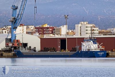
WILSON JUPITER
Cargo

Current Trip
| Trip Time | 9 days |
|---|---|
| Trip Distance | 1971.96 nm |
| AVG Speed | 8.6 Knots |
| MAX Speed | 13.4 Knots |
| Dybgang | 5.4 m |
| AVG Wind | 16.2 knots |
| MAX Wind | 24.6 knots |
| MIN Temp | -2.5°C / 27.5°F |
| MAX Temp | 15.3°C / 59.54°F |
| Position Modtaget | 3 m siden |
Current Position
| Longitude | --- |
|---|---|
| Latitude | --- |
| Status | Moored |
| Fart | 0.1 Knots |
| Kurs | 24° |
| Område | North Atlantic Ocean |
| Station | T-AIS |
| Position Modtaget | 3 m siden |
Information
The current position of WILSON JUPITER is in North Atlantic Ocean with coordinates 38.73424° / -9.10232° as reported on 2025-02-19 10:52 by AIS to our vessel tracker app. The vessel's current speed is 0.1 Knots and is currently inside the port of LISBOA.
The vessel WILSON JUPITER (IMO: 9411795, MMSI: 305819000) is a Cargo It's sailing under the flag of [AG] Antigua Barbuda.
In this page you can find informations about the vessels current position, last detected port calls, and current voyage information. If the vessels is not in coverage by AIS you will find the latest position.
The current position of WILSON JUPITER is detected by our AIS receivers and we are not responsible for the reliability of the data. The last position was recorded while the vessel was in Coverage by the Ais receivers of our vessel tracking app.
The current draught of WILSON JUPITER as reported by AIS is 5.4 meters
Weather
| Temperature | 13°C / 55.4°F |
|---|---|
| Wind Speed | 5 knots |
| Direction | 67° ENE |
| Pressure | 1019.7 hPa |
| Humidity | 86.7 % |
| Cloud Coverage | 12 % |


Featured Company
Last Port Calls
| Port | Arrival | Departure | Time In Port |
|---|---|---|---|
| 2025-02-18 20:50 | |||
| 2025-02-07 19:33 | 2025-02-09 21:05 | 2 d | |
| 2025-02-02 15:13 | 2025-02-04 14:28 | 1 d | |
| 2025-01-28 16:09 | 2025-01-29 16:12 | 1 d | |
| 2025-01-20 19:12 | 2025-01-25 18:54 | 4 d | |
| 2025-01-20 13:30 | 2025-01-20 18:30 | 5 h | |
| 2025-01-20 08:00 | 2025-01-20 13:22 | 5 h | |
| 2025-01-20 01:52 | 2025-01-20 07:41 | 5 h | |
| 2025-01-10 23:26 | 2025-01-14 18:32 | 3 d | |
| 2025-01-10 12:25 | 2025-01-10 12:49 | 23 m |
Most Visited Ports (Last year)
| Port | Arrivals | |
|---|---|---|
| 4 | ||
| 4 | ||
| 4 | ||
| 3 | ||
| 3 | ||
| 3 |
Last Trips
| Origin | Departure | Destination | Arrival | Distance | |
|---|---|---|---|---|---|
| 2025-02-09 21:05 | 2025-02-18 20:50 | 1971.96 nm | |||
| 2025-02-04 14:28 | 2025-02-07 19:33 | 599.25 nm | |||
| 2025-01-29 16:12 | 2025-02-02 15:13 | 640.60 nm | |||
| 2025-01-25 18:54 | 2025-01-28 16:09 | 685.04 nm | |||
| 2025-01-20 18:30 | 2025-01-20 19:12 | 6.62 nm | |||
| 2025-01-20 13:22 | 2025-01-20 13:30 | 2.54 nm | |||
| 2025-01-20 07:41 | 2025-01-20 08:00 | 3.36 nm | |||
| 2025-01-14 18:32 | 2025-01-20 01:52 | 728.57 nm | |||
| 2025-01-10 12:49 | 2025-01-10 23:26 | 15.47 nm | |||
| 2025-01-09 13:00 | 2025-01-10 12:25 | 0.47 nm |
Events
| Tid | Hændelsen | Detaljer | Position / Dest | Info |
|---|---|---|---|---|
| 2025-02-19 02:37 | Status er ændret | Moored Default |
38.73419 / -9.10225
[PT] LISBOA
|
Fart: Kurs: 25° |
| 2025-02-19 02:34 | Status er ændret | Default Moored |
38.73416 / -9.10226
[PT] LISBOA
|
Fart: Kurs: 25° |
| 2025-02-18 21:25 | Status er ændret | Moored Under way using engine |
38.73421 / -9.10228
[PT] LISBOA
|
Fart: Kurs: 25° |
| 2025-02-18 21:17 | STOP Sejllads |
38.73406 / -9.10230
[PT] LISBOA
|
Fart: 0.3 kn Kurs: 23° |
|
| 2025-02-18 20:50 | Skibe i havn |
|
38.70246 / -9.13479
[PT] LISBOA
|
Fart: 9.2 kn Kurs: 62.2° |
| 2025-02-18 18:19 | START Sejllads | 1.88 nm, South of CASCAIS |
38.66109 / -9.41888
PTLIS
|
Fart: 4.7 kn Kurs: 162° |
| 2025-02-18 18:15 | Status er ændret | Under way using engine At anchor |
38.66351 / -9.41862
PTLIS
|
Fart: 0.4 kn Kurs: 165° |
| 2025-02-18 13:12 | Status er ændret | At anchor Under way using engine |
38.66442 / -9.41780
PTLIS
|
Fart: 0.4 kn Kurs: 188° |
| 2025-02-18 12:57 | STOP Sejllads | 1.76 nm, South of CASCAIS |
38.66298 / -9.41806
PTLIS
|
Fart: 0.3 kn Kurs: 188° |
| 2025-02-18 09:48 | Dybgangen er ændret | 5.4 5.6 |
38.87145 / -9.71637
PTLIS
|
Fart: 8.9 kn Kurs: 175.3° |