
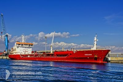
USICHEM
Oil/Chemical Tanker
Current Trip
| Time Travelled | 13 days |
|---|---|
| Remaining Time | --- |
| Distance Travelled | 1999.56 nm |
| Remaining Distance | --- |
| AVG Speed | 11.8 Knots |
| MAX Speed | 14.7 Knots |
| AVG Wind | 10.8 knots |
| MAX Wind | 27 knots |
| MIN Temp | 10°C / 50°F |
| MAX Temp | 23.8°C / 74.84°F |
| Dybgang | 5.7 m |
| Position Modtaget | 6 h, 53 m siden |
Current Position
| Longitude | 29.26148° |
|---|---|
| Latitude | 41.49659° |
| Status | Under way using engine |
| Fart | 12.9 Knots |
| Kurs | 7.1° |
| Område | Black Sea |
| Station | T-AIS |
| Position Modtaget | 6 h, 53 m siden |
Info
Information
The current position of USICHEM is in Black Sea with coordinates 41.49659° / 29.26148° as reported on 2024-04-27 09:30 by AIS to our vessel tracker app. The vessel's current speed is 12.9 Knots and is heading at the port of GALATI. The estimated time of arrival as calculated by MyShipTracking vessel tracking app is 2024-04-28 02:30 LT
The vessel USICHEM (IMO: 9344344, MMSI: 215993000) is a Oil/Chemical Tanker that was built in 2005 ( 19 år gamle ). It's sailing under the flag of [MT] Malta.
In this page you can find informations about the vessels current position, last detected port calls, and current voyage information. If the vessels is not in coverage by AIS you will find the latest position.
The current position of USICHEM is detected by our AIS receivers and we are not responsible for the reliability of the data. The last position was recorded while the vessel was in Coverage by the Ais receivers of our vessel tracking app.
The current draught of USICHEM as reported by AIS is 5.7 meters
Weather
| Temperature | 13.1°C / 55.58°F |
|---|---|
| Wind Speed | 15 knots |
| Direction | 31° NNE |
| Pressure | 1019.1 hPa |
| Humidity | 82.9 % |
| Cloud Coverage | 37 % |
Featured Company
Last Port Calls
| Port | Arrival | Departure | Time In Port |
|---|---|---|---|
| 2024-04-12 18:45 | 2024-04-14 11:39 | 1 d | |
| 2024-04-05 14:13 | 2024-04-07 17:26 | 2 d | |
| 2024-03-27 17:05 | 2024-03-30 11:44 | 2 d | |
| 2024-03-14 07:34 | 2024-03-15 14:06 | 1 d | |
| 2024-02-26 12:02 | 2024-02-28 21:29 | 2 d | |
| 2024-02-25 01:15 | 2024-02-25 05:26 | 4 h | |
| 2024-02-21 15:51 | 2024-02-23 07:05 | 1 d | |
| 2024-02-19 10:27 | |||
| 2024-02-12 21:23 | 2024-02-12 21:55 | 32 m | |
| 2024-02-10 10:26 | 2024-02-10 14:39 | 4 h |
Last Trips
| Origin | Departure | Destination | Arrival | Distance | |
|---|---|---|---|---|---|
| 2024-04-07 19:26 | 2024-04-12 20:45 | 702.11 nm | |||
| 2024-03-30 12:44 | 2024-04-05 16:13 | 1246.75 nm | |||
| 2024-03-15 16:06 | 2024-03-27 18:05 | 1850.34 nm | |||
| 2024-02-28 22:29 | 2024-03-14 09:34 | 2438.62 nm | |||
| 2024-02-25 06:26 | 2024-02-26 13:02 | 407.81 nm | |||
| 2024-02-23 08:05 | 2024-02-25 02:15 | 403.82 nm | |||
| 2024-02-19 11:27 | 2024-02-21 16:51 | 574.63 nm | |||
| 2024-02-10 15:39 | 2024-02-12 22:23 | 573.19 nm | |||
| 2024-01-31 07:59 | 2024-02-10 11:26 | 2183.71 nm |
Events
| Tid | Hændelsen | Detaljer | Position / Dest | Info |
|---|---|---|---|---|
| 2024-04-27 09:34 | Status er ændret | Default Under way using engine |
41.50865 / 29.26337
RO GAL
|
Fart: 12.9 kn Kurs: 7.1° |
| 2024-04-27 09:30 | Udenfor Dækning |
41.49659 / 29.26148
Black Sea
RO GAL
|
Fart: 12.9 kn Kurs: 7.1° |
|
| 2024-04-27 08:08 | Ændre havområde | Turkish part of the Black Sea Turkish part of the Sea of Marmara |
41.23254 / 29.14055
Black Sea
RO GAL
|
Fart: 11.8 kn Kurs: 34.4° |
| 2024-04-27 05:56 | ETA er ændret | 2024/04/28 02:30 2024/04/28 17:00 |
40.92401 / 28.95567
RO GAL
|
Fart: 11.2 kn Kurs: 26.9° |
| 2024-04-27 04:51 | START Sejllads | 9.81 nm, South of YESILKOY |
40.79382 / 28.79149
RO GAL
|
Fart: 3.5 kn Kurs: 349° |
| 2024-04-27 04:28 | STOP Sejllads | 9.89 nm, South of YESILKOY |
40.79108 / 28.80725
RO GAL
|
Fart: 0.3 kn Kurs: 42° |
| 2024-04-27 00:08 | START Sejllads | 11.38 nm, South of YESILKOY |
40.76652 / 28.85036
RO GAL
|
Fart: 3.1 kn Kurs: 69° |
| 2024-04-26 22:46 | STOP Sejllads | 10.97 nm, South of YESILKOY |
40.77490 / 28.86442
RO GAL
|
Fart: 0.3 kn Kurs: 73° |
| 2024-04-26 17:59 | START Sejllads | 2.78 nm, West of YESILKOY |
40.95567 / 28.76467
RO GAL
|
Fart: 3.7 kn Kurs: 166° |
| 2024-04-26 17:52 | Status er ændret | Under way using engine At anchor |
40.95497 / 28.76071
RO GAL
|
Fart: 0.5 kn Kurs: 291° |