
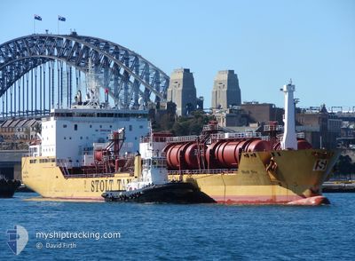
STOLT SEA
Oil/Chemical Tanker
Current Trip
| Time Travelled | 1 day |
|---|---|
| Remaining Time | --- |
| Distance Travelled | 493.13 nm |
| Remaining Distance | 6.31 nm |
| AVG Speed | 11.1 Knots |
| MAX Speed | 13.4 Knots |
| AVG Wind | 8 knots |
| MAX Wind | 15 knots |
| MIN Temp | 18.7°C / 65.66°F |
| MAX Temp | 25.1°C / 77.18°F |
| Dybgang | 10 m |
| Position Modtaget | 3 m siden |
Current Position
| Longitude | --- |
|---|---|
| Latitude | --- |
| Status | At anchor |
| Fart | |
| Kurs | 64° |
| Område | Gulf of Mexico |
| Station | T-AIS |
| Position Modtaget | 3 m siden |
Info
Information
The current position of STOLT SEA is in Gulf of Mexico with coordinates 22.53320° / -97.77550° as reported on 2024-12-18 22:42 by AIS to our vessel tracker app. The vessel's current speed is 0 Knots and is heading at the port of ALTAMIRA. The estimated time of arrival as calculated by MyShipTracking vessel tracking app is 2024-12-18 18:00 LT
The vessel STOLT SEA (IMO: 9149495, MMSI: 319478000) is a Oil/Chemical Tanker that was built in 1999 ( 25 år gamle ). It's sailing under the flag of [KY] Cayman Is.
In this page you can find informations about the vessels current position, last detected port calls, and current voyage information. If the vessels is not in coverage by AIS you will find the latest position.
The current position of STOLT SEA is detected by our AIS receivers and we are not responsible for the reliability of the data. The last position was recorded while the vessel was in Coverage by the Ais receivers of our vessel tracking app.
The current draught of STOLT SEA as reported by AIS is 10 meters
Weather
| Temperature | 24.1°C / 75.38°F |
|---|---|
| Wind Speed | 8 knots |
| Direction | 88° E |
| Pressure | 1018.3 hPa |
| Humidity | 78.6 % |
| Cloud Coverage | 84 % |
Featured Company
Last Port Calls
| Port | Arrival | Departure | Time In Port |
|---|---|---|---|
| 2024-12-15 20:42 | 2024-12-17 02:20 | 1 d | |
| 2024-12-09 22:21 | 2024-12-12 03:28 | 2 d | |
| 2024-12-06 08:34 | 2024-12-07 23:42 | 1 d | |
| 2024-12-04 12:49 | 2024-12-05 04:31 | 15 h | |
| 2024-11-26 18:59 | 2024-12-02 17:55 | 5 d | |
| 2024-11-20 04:24 | 2024-11-24 12:32 | 4 d | |
| 2024-11-16 23:50 | 2024-11-18 11:26 | 1 d | |
| 2024-11-15 14:50 | 2024-11-16 17:27 | 1 d | |
| 2024-11-12 20:19 | 2024-11-15 08:00 | 2 d | |
| 2024-11-12 01:05 | 2024-11-12 16:06 | 15 h |
Most Visited Ports (Last year)
| Port | Arrivals | |
|---|---|---|
| 30 | ||
| 19 | ||
| 10 | ||
| 4 | ||
| 2 | ||
| 2 |
Last Trips
| Origin | Departure | Destination | Arrival | Distance | |
|---|---|---|---|---|---|
| 2024-12-11 21:28 | 2024-12-15 14:42 | 59.29 nm | |||
| 2024-12-07 17:42 | 2024-12-09 16:21 | 506.14 nm | |||
| 2024-12-04 22:31 | 2024-12-06 02:34 | 13.23 nm | |||
| 2024-12-02 11:55 | 2024-12-04 06:49 | 498.41 nm | |||
| 2024-11-24 06:32 | 2024-11-26 12:59 | 505.09 nm | |||
| 2024-11-18 05:26 | 2024-11-19 22:24 | 495.07 nm | |||
| 2024-11-16 11:27 | 2024-11-16 17:50 | 48.11 nm | |||
| 2024-11-15 02:00 | 2024-11-15 08:50 | 25.61 nm | |||
| 2024-11-12 10:06 | 2024-11-12 14:19 | 27.54 nm | |||
| 2024-11-09 14:20 | 2024-11-11 19:05 | 493.34 nm |
Events
| Tid | Hændelsen | Detaljer | Position / Dest | Info |
|---|---|---|---|---|
| 2024-12-18 18:54 | Status er ændret | At anchor Under way using engine |
22.53273 / -97.77517
ALTAMIRA
|
Fart: 0.2 kn Kurs: 38° |
| 2024-12-18 18:41 | STOP Sejllads | 6.56 nm, North East of ALTAMIRA |
22.53371 / -97.77418
ALTAMIRA
|
Fart: 0.2 kn Kurs: 51° |
| 2024-12-18 17:39 | Status er ændret | Under way using engine Default |
22.58391 / -97.64530
ALTAMIRA
|
Fart: 12.8 kn Kurs: 223° |
| 2024-12-18 17:05 | Status er ændret | Default Under way using engine |
22.67407 / -97.55681
ALTAMIRA
|
Fart: 4.6 kn Kurs: 188° |
| 2024-12-18 16:52 | Ændre havområde | Mexican part of the Gulf of Mexico United States part of the Gulf of Mexico |
22.68153 / -97.56163
Gulf of Mexico
ALTAMIRA
|
Fart: 3.3 kn Kurs: 149.3° |
| 2024-12-18 16:50 | Status er ændret | Under way using engine Default |
22.68335 / -97.56264
ALTAMIRA
|
Fart: 7.4 kn Kurs: 208° |
| 2024-12-18 16:40 | Indenfor Dækning |
22.68153 / -97.56163
Gulf of Mexico
ALTAMIRA
|
Fart: 3.3 kn Kurs: 149.3° |
|
| 2024-12-17 03:55 | Status er ændret | Default Under way using engine |
29.34228 / -94.75780
ALTAMIRA
|
Fart: 12.1 kn Kurs: 139.5° |
| 2024-12-17 03:47 | Udenfor Dækning |
29.34893 / -94.78343
Gulf of Mexico
ALTAMIRA
|
Fart: 12.1 kn Kurs: 139.5° |
|
| 2024-12-17 03:02 | ETA er ændret | 2024/12/18 18:00 |
29.47611 / -94.85724
ALTAMIRA
|
Fart: 11.2 kn Kurs: 154.1° |