

SEATRIBUTE
Tanker
Current Trip
| Trip Time | 5 days |
|---|---|
| Trip Distance | 1566.00 nm |
| AVG Speed | 12.1 Knots |
| MAX Speed | 15.2 Knots |
| Dybgang | 8.3 m |
| AVG Wind | 5.6 knots |
| MAX Wind | 16.5 knots |
| MIN Temp | 9.1°C / 48.38°F |
| MAX Temp | 17°C / 62.6°F |
| Position Modtaget | 21 h, 8 m siden |
Current Position
| Longitude | --- |
|---|---|
| Latitude | --- |
| Status | Under way using engine |
| Fart | 8 Knots |
| Kurs | 60.7° |
| Område | Mediterranean Sea - Eastern Basin |
| Station | T-AIS |
| Position Modtaget | 21 h, 8 m siden |
Information
The current position of SEATRIBUTE is in Mediterranean Sea - Eastern Basin with coordinates 36.58183° / 35.76494° as reported on 2025-02-03 09:44 by AIS to our vessel tracker app. The vessel's current speed is 8 Knots and is currently inside the port of CEYHAN.
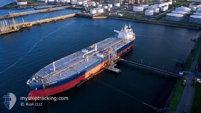
The vessel SEATRIBUTE (IMO: 9857468, MMSI: 215544000) is a Tanker It's sailing under the flag of [MT] Malta.
In this page you can find informations about the vessels current position, last detected port calls, and current voyage information. If the vessels is not in coverage by AIS you will find the latest position.
The current position of SEATRIBUTE is detected by our AIS receivers and we are not responsible for the reliability of the data. The last position was recorded while the vessel was in Coverage by the Ais receivers of our vessel tracking app.
The current draught of SEATRIBUTE as reported by AIS is 8.3 meters
Weather
| Temperature | 13.7°C / 56.66°F |
|---|---|
| Wind Speed | 5 knots |
| Direction | 16° NNE |
| Pressure | 1018.2 hPa |
| Humidity | 65.1 % |
| Cloud Coverage | 28 % |
Featured Company
Last Trips
| Origin | Departure | Destination | Arrival | Distance | |
|---|---|---|---|---|---|
| 2025-01-29 11:50 | 2025-02-03 16:42 | 1566.00 nm | |||
| 2025-01-14 06:33 | 2025-01-25 11:45 | 1669.10 nm | |||
| 2025-01-02 21:55 | 2025-01-13 12:25 | 1674.25 nm | |||
| 2024-12-03 16:13 | 2025-01-02 05:40 | 2948.26 nm | |||
| 2024-11-20 21:30 | 2024-12-03 14:36 | 1601.11 nm |
Events
| Tid | Hændelsen | Detaljer | Position / Dest | Info |
|---|---|---|---|---|
| 2025-02-03 13:55 | STOP Sejllads |
36.85235 / 35.93331
[TR] CEYHAN
|
Fart: Kurs: 184° |
|
| 2025-02-03 13:42 | Skibe i havn |
|
36.85235 / 35.93331
[TR] CEYHAN
|
Fart: 4.7 kn Kurs: 265° |
| 2025-02-03 13:05 | START Sejllads | 3.4 nm, East of CEYHAN |
36.85552 / 35.99047
TRCEY
|
Fart: 3.1 kn Kurs: 280° |
| 2025-02-03 12:45 | STOP Sejllads | 3.66 nm, East of CEYHAN |
36.85280 / 35.99605
TRCEY
|
Fart: 0.2 kn Kurs: 295° |
| 2025-02-03 09:48 | Status er ændret | Default Under way using engine |
36.58602 / 35.77412
TRCEY
|
Fart: 8 kn Kurs: 60.7° |
| 2025-02-03 09:44 | Udenfor Dækning |
36.58183 / 35.76494
Mediterranean Sea - Eastern Basin
TRCEY
|
Fart: 8 kn Kurs: 60.7° |
|
| 2025-02-03 04:52 | Ændre havområde | Turkish part of the Mediterranean Sea - Eastern Basin Cypriote part of the Mediterranean Sea - Eastern Basin |
36.19230 / 34.92809
Mediterranean Sea - Eastern Basin
TRCEY
|
Fart: 10.3 kn Kurs: 68.7° |
| 2025-02-03 04:50 | Status er ændret | Under way using engine Default |
36.19035 / 34.92130
TRCEY
|
Fart: 10.2 kn Kurs: 72° |
| 2025-02-03 04:31 | Status er ændret | Default Under way using engine |
36.17390 / 34.85880
TRCEY
|
Fart: 10.2 kn Kurs: 60.5° |
| 2025-02-03 04:03 | Fundet i havområde | Cypriote part of the Mediterranean Sea - Eastern Basin |
36.13689 / 34.76885
Mediterranean Sea - Eastern Basin
TRCEY
|
Fart: 10.3 kn Kurs: 63.2° |