
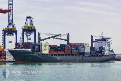
SHIRIN M
Container Ship
Current Trip
| Trip Time | 4 days |
|---|---|
| Trip Distance | 283.26 nm |
| AVG Speed | 12.2 Knots |
| MAX Speed | 12.2 Knots |
| Dybgang | 10.1 m |
| AVG Wind | 7.8 knots |
| MAX Wind | 15.3 knots |
| MIN Temp | 4.3°C / 39.74°F |
| MAX Temp | 8.4°C / 47.12°F |
| Position Modtaget | 2 m siden |
Current Position
| Longitude | --- |
|---|---|
| Latitude | --- |
| Status | Moored |
| Fart | |
| Kurs | 113° |
| Område | North Sea |
| Station | T-AIS |
| Position Modtaget | 2 m siden |
Info
Information
The current position of SHIRIN M is in North Sea with coordinates 51.35000° / 4.26733° as reported on 2025-03-04 11:13 by AIS to our vessel tracker app. The vessel's current speed is 0 Knots and is currently inside the port of ANTWERP.
The vessel SHIRIN M (IMO: 9339583, MMSI: 636017112) is a Container Ship that was built in 2007 ( 18 år gamle ). It's sailing under the flag of [LR] Liberia.
In this page you can find informations about the vessels current position, last detected port calls, and current voyage information. If the vessels is not in coverage by AIS you will find the latest position.
The current position of SHIRIN M is detected by our AIS receivers and we are not responsible for the reliability of the data. The last position was recorded while the vessel was in Coverage by the Ais receivers of our vessel tracking app.
The current draught of SHIRIN M as reported by AIS is 10.1 meters
Weather
| Temperature | 9.6°C / 49.28°F |
|---|---|
| Wind Speed | 2 knots |
| Direction | 142° SE |
| Pressure | 1026.8 hPa |
| Humidity | 48 % |
| Cloud Coverage | 37 % |
Featured Company
Last Port Calls
| Port | Arrival | Departure | Time In Port |
|---|---|---|---|
| 2025-03-03 22:09 | |||
| 2025-02-27 07:06 | 2025-02-27 19:00 | 11 h | |
| 2025-02-18 22:00 | 2025-02-19 15:16 | 17 h | |
| 2025-02-14 07:45 | 2025-02-14 20:20 | 12 h | |
| 2025-02-13 02:29 | 2025-02-13 12:30 | 10 h | |
| 2025-02-11 22:09 | 2025-02-12 20:44 | 22 h | |
| 2025-02-09 10:52 | 2025-02-10 10:35 | 23 h | |
| 2025-02-03 16:28 | 2025-02-04 18:27 | 1 d | |
| 2025-01-19 06:51 | 2025-01-20 10:26 | 1 d | |
| 2025-01-15 13:47 | 2025-01-16 17:34 | 1 d |
Most Visited Ports (Last year)
| Port | Arrivals | |
|---|---|---|
| 17 | ||
| 8 | ||
| 7 | ||
| 6 | ||
| 4 | ||
| 2 |
Last Trips
| Origin | Departure | Destination | Arrival | Distance | |
|---|---|---|---|---|---|
| 2025-02-27 19:00 | 2025-03-03 23:09 | 283.26 nm | |||
| 2025-02-19 17:16 | 2025-02-27 07:06 | 2711.98 nm | |||
| 2025-02-14 23:20 | 2025-02-19 00:00 | 216.82 nm | |||
| 2025-02-13 15:30 | 2025-02-14 10:45 | 286.89 nm | |||
| 2025-02-12 23:44 | 2025-02-13 05:29 | 61.65 nm | |||
| 2025-02-10 13:35 | 2025-02-12 01:09 | 66.11 nm | |||
| 2025-02-04 20:27 | 2025-02-09 13:52 | 415.60 nm | |||
| 2025-01-20 11:26 | 2025-02-03 18:28 | 2998.78 nm | |||
| 2025-01-16 18:34 | 2025-01-19 07:51 | 130.21 nm | |||
| 2025-01-14 14:23 | 2025-01-15 14:47 | 180.23 nm |
Events
| Tid | Hændelsen | Detaljer | Position / Dest | Info |
|---|---|---|---|---|
| 2025-03-03 22:52 | Status er ændret | Moored Under way using engine |
51.35000 / 4.26733
[BE] ANTWERP
|
Fart: Kurs: 113° |
| 2025-03-03 22:38 | STOP Sejllads |
51.34967 / 4.26733
[BE] ANTWERP
|
Fart: 0.3 kn Kurs: 116° |
|
| 2025-03-03 22:09 | Skibe i havn |
|
51.36617 / 4.22050
[BE] ANTWERP
|
Fart: 10.9 kn Kurs: 164° |
| 2025-03-03 18:53 | Ændre havområde | Dutch part of the North Sea Belgian part of the North Sea |
51.40767 / 3.33133
North Sea
BEANR
|
Fart: 16.4 kn Kurs: 87° |
| 2025-03-03 15:42 | ETA er ændret | 2025/03/03 17:30 2025/03/03 16:40 |
51.42300 / 2.63467
BEANR
|
Fart: 4.2 kn Kurs: 231° |
| 2025-03-03 15:25 | START Sejllads | 16.63 nm, North West of OOSTENDE |
51.43650 / 2.65600
BEANR
|
Fart: 3.1 kn Kurs: 225° |
| 2025-03-03 15:13 | Status er ændret | Under way using engine At anchor |
51.44017 / 2.66033
BEANR
|
Fart: 0.1 kn Kurs: 242° |
| 2025-03-03 14:09 | Dybgangen er ændret | 10.1 10.2 |
51.44033 / 2.66083
BEANR
|
Fart: 0.1 kn Kurs: 243° |
| 2025-03-03 14:09 | ETA er ændret | 2025/03/03 16:40 2026/02/28 14:00 |
51.44033 / 2.66083
BEANR
|
Fart: 0.1 kn Kurs: 243° |
| 2025-03-03 12:35 | Status er ændret | At anchor Default |
51.43733 / 2.65700
BEANR
|
Fart: 0.1 kn Kurs: 32° |