
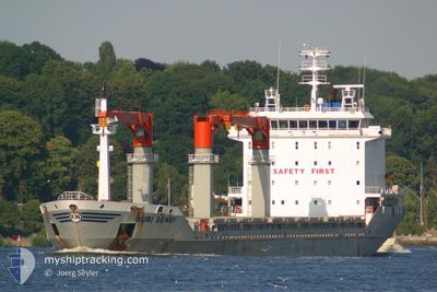
NURI SONAY
General Cargo
Current Trip
| Trip Time | 1 day |
|---|---|
| Trip Distance | 483.23 nm |
| AVG Speed | 11.8 Knots |
| MAX Speed | 13.2 Knots |
| Dybgang | 6.6 m |
| AVG Wind | 14.9 knots |
| MAX Wind | 21 knots |
| MIN Temp | 16.7°C / 62.06°F |
| MAX Temp | 22.4°C / 72.32°F |
| Position Modtaget | 4 d siden |
Current Position
| Longitude | 27.24185° |
|---|---|
| Latitude | 36.95544° |
| Status | Under way using engine |
| Fart | 11.8 Knots |
| Kurs | 293.5° |
| Område | Aegean Sea |
| Station | T-AIS |
| Position Modtaget | 4 d siden |
Info
Information
The current position of NURI SONAY is in Aegean Sea with coordinates 36.95544° / 27.24185° as reported on 2024-05-13 07:04 by AIS to our vessel tracker app. The vessel's current speed is 11.8 Knots and is currently inside the port of GULLUK.
The vessel NURI SONAY (IMO: 9310202, MMSI: 371251000) is a General Cargo that was built in 2006 ( 18 år gamle ). It's sailing under the flag of [PA] Panama.
In this page you can find informations about the vessels current position, last detected port calls, and current voyage information. If the vessels is not in coverage by AIS you will find the latest position.
The current position of NURI SONAY is detected by our AIS receivers and we are not responsible for the reliability of the data. The last position was recorded while the vessel was in Coverage by the Ais receivers of our vessel tracking app.
The current draught of NURI SONAY as reported by AIS is 6.6 meters
Weather
| Temperature | 21.8°C / 71.24°F |
|---|---|
| Wind Speed | 10 knots |
| Direction | 296° WNW |
| Pressure | 1019.7 hPa |
| Humidity | 54.6 % |
| Cloud Coverage | 79 % |
Featured Company
Last Port Calls
| Port | Arrival | Departure | Time In Port |
|---|---|---|---|
| 2024-05-13 10:15 | |||
| 2024-05-07 12:46 | 2024-05-11 15:08 | 4 d | |
| 2024-04-26 13:34 | 2024-04-29 05:00 | 2 d | |
| 2024-04-16 07:08 | 2024-04-18 07:08 | 2 d | |
| 2024-04-15 06:20 | 2024-04-16 06:23 | 1 d | |
| 2024-03-30 12:33 | 2024-04-07 08:45 | 7 d | |
| 2024-03-22 05:36 | 2024-03-30 10:43 | 8 d | |
| 2024-03-01 12:49 |
Most Visited Ports (Last year)
| Port | Arrivals | |
|---|---|---|
| 5 | ||
| 3 | ||
| 3 | ||
| 2 | ||
| 2 | ||
| 2 |
Last Trips
| Origin | Departure | Destination | Arrival | Distance | |
|---|---|---|---|---|---|
| 2024-05-11 17:08 | 2024-05-13 13:15 | 483.23 nm | |||
| 2024-04-29 07:00 | 2024-05-07 14:46 | 179.74 nm | |||
| 2024-04-18 08:08 | 2024-04-26 15:34 | 2029.92 nm | |||
| 2024-04-16 07:23 | 2024-04-16 08:08 | 4.05 nm | |||
| 2024-04-07 10:45 | 2024-04-15 07:20 | 1506.36 nm | |||
| 2024-03-30 11:43 | 2024-03-30 13:33 | 23.55 nm | |||
| 2024-02-22 20:12 | 2024-03-01 15:49 | 1325.22 nm |
Events
| Tid | Hændelsen | Detaljer | Position / Dest | Info |
|---|---|---|---|---|
| 2024-05-13 10:15 | Skibe i havn |
|
37.25299 / 27.60623
[TR] GULLUK
|
Fart: 7.4 kn Kurs: 46° |
| 2024-05-13 07:24 | Status er ændret | Default Under way using engine |
36.98433 / 27.16738
GULLUK
|
Fart: 11.8 kn Kurs: 293.5° |
| 2024-05-13 07:04 | Udenfor Dækning |
36.95544 / 27.24185
Aegean Sea
GULLUK
|
Fart: 11.8 kn Kurs: 293.5° |
|
| 2024-05-13 06:49 | Indenfor Dækning |
36.94157 / 27.28134
Aegean Sea
GULLUK
|
Fart: 11.6 kn Kurs: 294° |
|
| 2024-05-13 05:31 | Udenfor Dækning |
36.72767 / 27.34935
Aegean Sea
GULLUK
|
Fart: 11.3 kn Kurs: 13.4° |
|
| 2024-05-13 04:08 | Ændre havområde | Turkish part of the Aegean Sea Greek part of the Aegean Sea |
36.57177 / 27.58029
Aegean Sea
GULLUK
|
Fart: 11.8 kn Kurs: 302.5° |
| 2024-05-13 02:39 | Status er ændret | Under way using engine Default |
36.48413 / 27.92385
GULLUK
|
Fart: 12.5 kn Kurs: 268° |
| 2024-05-13 02:07 | Status er ændret | Default Under way using engine |
36.48820 / 28.06197
GULLUK
|
Fart: 11.7 kn Kurs: 265.5° |
| 2024-05-13 01:29 | Ændre havområde | Greek part of the Aegean Sea Greek part of the Mediterranean Sea - Eastern Basin |
36.49621 / 28.21506
Aegean Sea
GULLUK
|
Fart: 11.7 kn Kurs: 268.5° |
| 2024-05-12 23:02 | Ændre havområde | Greek part of the Mediterranean Sea - Eastern Basin Turkish part of the Mediterranean Sea - Eastern Basin |
36.17905 / 28.67109
Mediterranean Sea - Eastern Basin
GULLUK
|
Fart: 11.8 kn Kurs: 312.1° |