
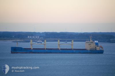
NORDIC MALMOE
Bulk Carrier
Current Trip
| Trip Time | 3 days |
|---|---|
| Trip Distance | 510.39 nm |
| AVG Speed | 11.3 Knots |
| MAX Speed | 15.5 Knots |
| Dybgang | 6.8 m |
| AVG Wind | 15.4 knots |
| MAX Wind | 23.9 knots |
| MIN Temp | 16.8°C / 62.24°F |
| MAX Temp | 29.7°C / 85.46°F |
| Position Modtaget | 1 d siden |
Current Position
| Longitude | -93.25597° |
|---|---|
| Latitude | 30.21071° |
| Status | Moored |
| Fart | |
| Kurs | 288° |
| Område | Gulf of Mexico |
| Station | T-AIS |
| Position Modtaget | 1 d siden |
Info
Information
The current position of NORDIC MALMOE is in Gulf of Mexico with coordinates 30.21071° / -93.25597° as reported on 2024-05-03 23:16 by AIS to our vessel tracker app. The vessel's current speed is 0 Knots and is currently inside the port of LAKE CHARLES.
The vessel NORDIC MALMOE (IMO: 9602679, MMSI: 636092675) is a Bulk Carrier that was built in 2012 ( 12 år gamle ). It's sailing under the flag of [LR] Liberia.
In this page you can find informations about the vessels current position, last detected port calls, and current voyage information. If the vessels is not in coverage by AIS you will find the latest position.
The current position of NORDIC MALMOE is detected by our AIS receivers and we are not responsible for the reliability of the data. The last position was recorded while the vessel was in Coverage by the Ais receivers of our vessel tracking app.
The current draught of NORDIC MALMOE as reported by AIS is 6.8 meters
Weather
| Temperature | 27.7°C / 81.86°F |
|---|---|
| Wind Speed | 14 knots |
| Direction | 180° S |
| Pressure | 1013 hPa |
| Humidity | 63.1 % |
| Cloud Coverage | 100 % |
Featured Company
Last Port Calls
| Port | Arrival | Departure | Time In Port |
|---|---|---|---|
| 2024-04-29 00:14 | |||
| 2024-04-25 05:47 | 2024-04-25 10:59 | 5 h | |
| 2024-04-18 10:46 | 2024-04-19 13:27 | 1 d | |
| 2024-04-09 18:18 | 2024-04-16 15:40 | 6 d | |
| 2024-03-22 19:36 |
Last Trips
| Origin | Departure | Destination | Arrival | Distance | |
|---|---|---|---|---|---|
| 2024-04-25 05:59 | 2024-04-28 19:14 | 510.39 nm | |||
| 2024-04-19 09:27 | 2024-04-25 00:47 | 1420.44 nm | |||
| 2024-04-16 11:40 | 2024-04-18 06:46 | 402.77 nm | |||
| 2024-03-22 20:36 | 2024-04-09 14:18 | 3848.83 nm |
Events
| Tid | Hændelsen | Detaljer | Position / Dest | Info |
|---|---|---|---|---|
| 2024-05-03 23:22 | Status er ændret | Default Moored |
30.21071 / -93.25593
[US] LAKE CHARLES
|
Fart: Kurs: 288° |
| 2024-05-03 23:16 | Udenfor Dækning |
30.21071 / -93.25597
Gulf of Mexico
[US] LAKE CHARLES
|
Fart: Kurs: 333.9° |
|
| 2024-05-03 22:10 | Status er ændret | Moored Default |
30.21068 / -93.25595
[US] LAKE CHARLES
|
Fart: Kurs: 288° |
| 2024-05-03 22:04 | Status er ændret | Default Moored |
30.21065 / -93.25592
[US] LAKE CHARLES
|
Fart: Kurs: 288° |
| 2024-05-03 21:40 | Status er ændret | Moored Default |
30.21068 / -93.25594
[US] LAKE CHARLES
|
Fart: Kurs: 288° |
| 2024-05-03 21:40 | Indenfor Dækning |
30.21068 / -93.25594
Gulf of Mexico
[US] LAKE CHARLES
|
Fart: Kurs: 333.9° |
|
| 2024-05-01 14:04 | Status er ændret | Default Moored |
30.21069 / -93.25596
[US] LAKE CHARLES
|
Fart: Kurs: 288° |
| 2024-05-01 14:01 | Status er ændret | Moored Default |
30.21069 / -93.25595
[US] LAKE CHARLES
|
Fart: Kurs: 288° |
| 2024-05-01 14:01 | Udenfor Dækning |
30.21069 / -93.25595
Gulf of Mexico
[US] LAKE CHARLES
|
Fart: Kurs: 333.9° |
|
| 2024-05-01 13:49 | Status er ændret | Default Moored |
30.21068 / -93.25594
[US] LAKE CHARLES
|
Fart: Kurs: 288° |