
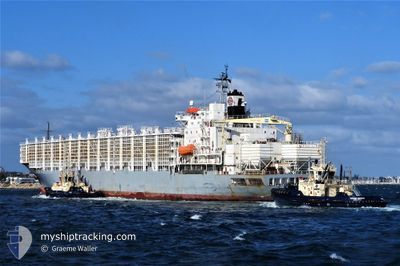
MAYSORA
Livestock Carrier
Current Trip
| Time Travelled | 3 days |
|---|---|
| Remaining Time | --- |
| Distance Travelled | 1263.40 nm |
| Remaining Distance | --- |
| AVG Speed | 14.5 Knots |
| MAX Speed | 16.2 Knots |
| AVG Wind | 16.4 knots |
| MAX Wind | 23.8 knots |
| MIN Temp | 15.8°C / 60.44°F |
| MAX Temp | 26.9°C / 80.42°F |
| Dybgang | 10 m |
| Position Modtaget | 3 d siden |
Current Position
| Longitude | -54.75766° |
|---|---|
| Latitude | -35.06569° |
| Status | Under way using engine |
| Fart | 14.2 Knots |
| Kurs | 87.1° |
| Område | South Atlantic Ocean |
| Station | T-AIS |
| Position Modtaget | 3 d siden |
Info
Information
The current position of MAYSORA is in South Atlantic Ocean with coordinates -35.06569° / -54.75766° as reported on 2024-05-02 03:00 by AIS to our vessel tracker app. The vessel's current speed is 14.2 Knots and is heading at the port of MERSIN. The estimated time of arrival as calculated by MyShipTracking vessel tracking app is 2024-05-22 02:00 LT
The vessel MAYSORA (IMO: 8310542, MMSI: 511100869) is a Livestock Carrier that was built in 1989 ( 35 år gamle ). It's sailing under the flag of [PW] Palau.
In this page you can find informations about the vessels current position, last detected port calls, and current voyage information. If the vessels is not in coverage by AIS you will find the latest position.
The current position of MAYSORA is detected by our AIS receivers and we are not responsible for the reliability of the data. The last position was recorded while the vessel was in Coverage by the Ais receivers of our vessel tracking app.
The current draught of MAYSORA as reported by AIS is 10 meters
Weather
| Temperature | 26.6°C / 79.88°F |
|---|---|
| Wind Speed | 13 knots |
| Direction | 87° E |
| Pressure | 1019.7 hPa |
| Humidity | 69.4 % |
| Cloud Coverage | --- |
Featured Company
Last Port Calls
| Port | Arrival | Departure | Time In Port |
|---|---|---|---|
| 2024-04-26 12:45 | 2024-05-01 21:12 | 5 d | |
| 2024-04-06 04:29 | 2024-04-06 13:21 | 8 h | |
| 2024-04-04 01:51 | |||
| 2024-03-12 15:46 | 2024-03-16 08:26 | 3 d |
Most Visited Ports (Last year)
| Port | Arrivals | |
|---|---|---|
| 4 | ||
| 3 | ||
| 2 | ||
| 1 | ||
| 1 | ||
| 1 |
Last Trips
| Origin | Departure | Destination | Arrival | Distance | |
|---|---|---|---|---|---|
| 2024-04-04 04:51 | 2024-04-26 09:45 | 7587.32 nm | |||
| 2024-04-04 04:51 | 2024-04-06 06:29 | 324.27 nm | |||
| 2024-01-09 17:05 | 2024-03-12 23:46 | 2316.53 nm |
Events
| Tid | Hændelsen | Detaljer | Position / Dest | Info |
|---|---|---|---|---|
| 2024-05-02 03:04 | Status er ændret | Default Under way using engine |
-35.06500 / -54.73833
MERSIN
|
Fart: 14.2 kn Kurs: 87.1° |
| 2024-05-02 03:00 | Status er ændret | Under way using engine Default |
-35.06569 / -54.75766
MERSIN
|
Fart: 14.3 kn Kurs: 88° |
| 2024-05-02 03:00 | Udenfor Dækning |
-35.06569 / -54.75766
South Atlantic Ocean
MERSIN
|
Fart: 14.2 kn Kurs: 87.1° |
|
| 2024-05-02 02:56 | Status er ændret | Default Under way using engine |
-35.06628 / -54.77707
MERSIN
|
Fart: 14.4 kn Kurs: 89.6° |
| 2024-05-02 02:11 | Ændre havområde | Uruguayan part of the South Atlantic Ocean Uruguayan part of the Rio de La Plata |
-35.06486 / -55.00533
South Atlantic Ocean
MERSIN
|
Fart: 15 kn Kurs: 91.1° |
| 2024-05-02 02:09 | Status er ændret | Under way using engine Default |
-35.06475 / -55.01246
MERSIN
|
Fart: 15 kn Kurs: 91° |
| 2024-05-02 01:48 | Status er ændret | Default Under way using engine |
-35.06387 / -55.12280
MERSIN
|
Fart: 14.8 kn Kurs: 91.1° |
| 2024-05-02 01:39 | Status er ændret | Under way using engine Default |
-35.06340 / -55.16503
MERSIN
|
Fart: 14.7 kn Kurs: 90° |
| 2024-05-02 01:28 | Status er ændret | Default Under way using engine |
-35.06167 / -55.21833
MERSIN
|
Fart: 14.5 kn Kurs: 89.4° |
| 2024-05-02 01:13 | Dybgangen er ændret | 10 8.6 |
-35.06201 / -55.29679
MERSIN
|
Fart: 14.5 kn Kurs: 89.8° |