

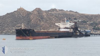
MAIRAKI
Bulk Carrier

Current Trip
| Time Travelled | 20 days |
|---|---|
| Remaining Time | 7 h, 29 mins |
| Distance Travelled | 541.74 nm |
| Remaining Distance | 88.85 nm |
| AVG Speed | 9 Knots |
| MAX Speed | 11.9 Knots |
| AVG Wind | 10.8 knots |
| MAX Wind | 22 knots |
| MIN Temp | 18.2°C / 64.76°F |
| MAX Temp | 23.5°C / 74.3°F |
| Dybgang | 9.4 m |
| Position Modtaget | 7 h, 3 m siden |
Current Position
| Longitude | --- |
|---|---|
| Latitude | --- |
| Status | Under way using engine |
| Fart | 10.2 Knots |
| Kurs | 47.4° |
| Område | Persian Gulf |
| Station | T-AIS |
| Position Modtaget | 7 h, 3 m siden |
Information
The current position of MAIRAKI is in Persian Gulf with coordinates 26.27915° / 55.69812° as reported on 2025-02-18 06:12 by AIS to our vessel tracker app. The vessel's current speed is 10.2 Knots and is heading at the port of FUJAIRAH. The estimated time of arrival as calculated by MyShipTracking vessel tracking app is 2025-02-18 20:45 LT
The vessel MAIRAKI (IMO: 9444546, MMSI: 538004073) is a Bulk Carrier that was built in 2011 ( 14 år gamle ). It's sailing under the flag of [MH] Marshall Is.
In this page you can find informations about the vessels current position, last detected port calls, and current voyage information. If the vessels is not in coverage by AIS you will find the latest position.
The current position of MAIRAKI is detected by our AIS receivers and we are not responsible for the reliability of the data. The last position was recorded while the vessel was in Coverage by the Ais receivers of our vessel tracking app.
The current draught of MAIRAKI as reported by AIS is 9.4 meters
Weather
| Temperature | 23.7°C / 74.66°F |
|---|---|
| Wind Speed | 5 knots |
| Direction | 292° WNW |
| Pressure | 1013.5 hPa |
| Humidity | 69.2 % |
| Cloud Coverage | 98 % |


Featured Company
Events
| Tid | Hændelsen | Detaljer | Position / Dest | Info |
|---|---|---|---|---|
| 2025-02-18 06:17 | Status er ændret | Default Under way using engine |
26.28868 / 55.70935
AE FJR
|
Fart: 10.2 kn Kurs: 47.4° |
| 2025-02-18 06:12 | Udenfor Dækning |
26.27915 / 55.69812
Persian Gulf
AE FJR
|
Fart: 10.2 kn Kurs: 47.4° |
|
| 2025-02-18 01:41 | Status er ændret | Under way using engine Default |
26.14745 / 54.87541
AE FJR
|
Fart: 9.9 kn Kurs: 93° |
| 2025-02-18 01:21 | Indenfor Dækning |
26.14745 / 54.87541
Persian Gulf
AE FJR
|
Fart: 10 kn Kurs: 92.2° |
|
| 2025-02-17 20:18 | Status er ændret | Default Under way using engine |
25.88737 / 54.01107
AE FJR
|
Fart: 10 kn Kurs: 23.2° |
| 2025-02-17 20:17 | Udenfor Dækning |
25.88479 / 54.00983
Persian Gulf
AE FJR
|
Fart: 10 kn Kurs: 23.2° |
|
| 2025-02-17 20:12 | Status er ændret | Under way using engine Default |
25.87193 / 54.00370
AE FJR
|
Fart: 10 kn Kurs: 23° |
| 2025-02-17 19:24 | Status er ændret | Default Under way using engine |
25.74403 / 53.95828
AE FJR
|
Fart: 10 kn Kurs: 5.1° |
| 2025-02-17 18:43 | Ændre havområde | Iranian part of the Persian Gulf United Arab Emirates part of the Persian Gulf |
25.62838 / 53.96498
Persian Gulf
AE FJR
|
Fart: 10 kn Kurs: 346.7° |
| 2025-02-17 18:25 | Status er ændret | Under way using engine Default |
25.58394 / 53.98920
AE FJR
|
Fart: 9.7 kn Kurs: 331° |