
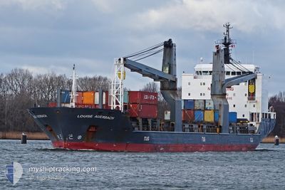
LOUISE AUERBACH
General Cargo
Current Trip
USMOB
| Time Travelled | 2 days |
|---|---|
| Remaining Time | --- |
| Distance Travelled | 349.54 nm |
| Remaining Distance | --- |
| AVG Speed | 12.5 Knots |
| MAX Speed | 14.3 Knots |
| AVG Wind | 19.3 knots |
| MAX Wind | 30.2 knots |
| MIN Temp | 15.6°C / 60.08°F |
| MAX Temp | 22.8°C / 73.04°F |
| Dybgang | 6.5 m |
| Position Modtaget | 4 h, 55 m siden |
Current Position
| Longitude | --- |
|---|---|
| Latitude | --- |
| Status | At anchor |
| Fart | 0.3 Knots |
| Kurs | 333° |
| Område | Gulf of Mexico |
| Station | T-AIS |
| Position Modtaget | 4 h, 55 m siden |
Info
Information
The current position of LOUISE AUERBACH is in Gulf of Mexico with coordinates 27.62371° / -83.07162° as reported on 2025-02-18 00:57 by AIS to our vessel tracker app. The vessel's current speed is 0.3 Knots
The vessel LOUISE AUERBACH (IMO: 9388895, MMSI: 636092892) is a General Cargo that was built in 2007 ( 18 år gamle ). It's sailing under the flag of [LR] Liberia.
In this page you can find informations about the vessels current position, last detected port calls, and current voyage information. If the vessels is not in coverage by AIS you will find the latest position.
The current position of LOUISE AUERBACH is detected by our AIS receivers and we are not responsible for the reliability of the data. The last position was recorded while the vessel was in Coverage by the Ais receivers of our vessel tracking app.
The current draught of LOUISE AUERBACH as reported by AIS is 6.5 meters
Weather
| Temperature | 18.2°C / 64.76°F |
|---|---|
| Wind Speed | 16 knots |
| Direction | 35° NE |
| Pressure | 1020.3 hPa |
| Humidity | 54.8 % |
| Cloud Coverage | --- |
Featured Company
Last Port Calls
| Port | Arrival | Departure | Time In Port |
|---|---|---|---|
| 2025-02-15 03:35 | 2025-02-16 04:11 | 1 d | |
| 2025-02-11 22:56 | 2025-02-14 09:19 | 2 d | |
| 2025-02-09 12:39 | 2025-02-10 18:31 | 1 d | |
| 2025-02-07 21:41 | 2025-02-08 06:50 | 9 h | |
| 2025-01-20 13:58 | 2025-01-22 05:58 | 1 d | |
| 2025-01-08 19:29 | 2025-01-10 22:45 | 2 d | |
| 2024-12-25 17:37 | 2024-12-27 11:44 | 1 d | |
| 2024-12-22 15:11 | 2024-12-24 19:37 | 2 d | |
| 2024-12-15 23:16 | 2024-12-17 17:49 | 1 d | |
| 2024-12-14 11:33 | 2024-12-14 19:40 | 8 h |
Most Visited Ports (Last year)
| Port | Arrivals | |
|---|---|---|
| 3 | ||
| 2 | ||
| 2 | ||
| 2 | ||
| 1 | ||
| 1 |
Last Trips
| Origin | Departure | Destination | Arrival | Distance | |
|---|---|---|---|---|---|
| 2025-02-14 03:19 | 2025-02-14 21:35 | 229.29 nm | |||
| 2025-02-10 12:31 | 2025-02-11 16:56 | 326.70 nm | |||
| 2025-02-08 01:50 | 2025-02-09 06:39 | 275.71 nm | |||
| 2025-01-22 00:58 | 2025-02-07 16:41 | 3145.44 nm | |||
| 2025-01-10 19:45 | 2025-01-20 08:58 | 795.84 nm | |||
| 2024-12-27 08:44 | 2025-01-08 16:29 | 12.55 nm | |||
| 2024-12-24 16:37 | 2024-12-25 14:37 | 3.80 nm | |||
| 2024-12-17 14:49 | 2024-12-22 12:11 | 455.27 nm | |||
| 2024-12-14 14:40 | 2024-12-15 20:16 | 230.96 nm | |||
| 2024-11-27 20:46 | 2024-12-14 06:33 | 3268.50 nm |
Events
| Tid | Hændelsen | Detaljer | Position / Dest | Info |
|---|---|---|---|---|
| 2025-02-18 01:21 | Status er ændret | Default At anchor |
27.62358 / -83.07197
USMOB
|
Fart: 0.3 kn Kurs: 333° |
| 2025-02-18 00:57 | Status er ændret | At anchor Default |
27.62371 / -83.07162
USMOB
|
Fart: 0.4 kn Kurs: 340° |
| 2025-02-18 00:57 | Indenfor Dækning |
27.62371 / -83.07162
Gulf of Mexico
|
Fart: 0.3 kn Kurs: 79° |
|
| 2025-02-18 00:57 | Udenfor Dækning |
27.62371 / -83.07162
Gulf of Mexico
|
Fart: 0.3 kn Kurs: 79° |
|
| 2025-02-17 16:36 | Status er ændret | Default At anchor |
27.62390 / -83.07147
USMOB
|
Fart: 0.1 kn Kurs: 344° |
| 2025-02-17 16:27 | Status er ændret | At anchor Default |
27.62359 / -83.07209
USMOB
|
Fart: 0.3 kn Kurs: 344° |
| 2025-02-17 16:27 | Indenfor Dækning |
27.62359 / -83.07209
Gulf of Mexico
|
Fart: 0.1 kn Kurs: 123.4° |
|
| 2025-02-17 16:27 | Udenfor Dækning |
27.62359 / -83.07209
Gulf of Mexico
|
Fart: 0.1 kn Kurs: 123.4° |
|
| 2025-02-17 08:42 | STOP Sejllads | 19.22 nm, West of TIERRA VERDE |
27.62365 / -83.07179
USMOB
|
Fart: 0.1 kn Kurs: 340° |
| 2025-02-17 05:16 | Udenfor Dækning |
27.58637 / -83.48202
Gulf of Mexico
|
Fart: 13.5 kn Kurs: 87.5° |