
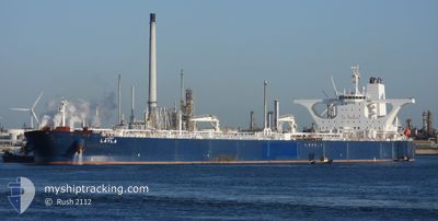
LAYLA
Crude Oil Tanker
Current Trip
SAJUT
| Time Travelled | 14 days |
|---|---|
| Remaining Time | --- |
| Distance Travelled | 3387.72 nm |
| Remaining Distance | --- |
| AVG Speed | 11.2 Knots |
| MAX Speed | 15.7 Knots |
| AVG Wind | 8.6 knots |
| MAX Wind | 27.2 knots |
| MIN Temp | 20.5°C / 68.9°F |
| MAX Temp | 33.5°C / 92.3°F |
| Dybgang | 10.7 m |
| Position Modtaget | 5 h, 52 m siden |
Current Position
| Longitude | 56.81663° |
|---|---|
| Latitude | 25.90168° |
| Status | Under way using engine |
| Fart | 14.3 Knots |
| Kurs | 8° |
| Område | Gulf of Oman |
| Station | T-AIS |
| Position Modtaget | 5 h, 52 m siden |
Info
Information
The current position of LAYLA is in Gulf of Oman with coordinates 25.90168° / 56.81663° as reported on 2024-05-04 19:46 by AIS to our vessel tracker app. The vessel's current speed is 14.3 Knots
The vessel LAYLA (IMO: 9336098, MMSI: 403507001) is a Crude Oil Tanker that was built in 2007 ( 17 år gamle ). It's sailing under the flag of [SA] Saudi Arabia.
In this page you can find informations about the vessels current position, last detected port calls, and current voyage information. If the vessels is not in coverage by AIS you will find the latest position.
The current position of LAYLA is detected by our AIS receivers and we are not responsible for the reliability of the data. The last position was recorded while the vessel was in Coverage by the Ais receivers of our vessel tracking app.
The current draught of LAYLA as reported by AIS is 10.7 meters
Weather
| Temperature | 27.6°C / 81.68°F |
|---|---|
| Wind Speed | 3 knots |
| Direction | 68° ENE |
| Pressure | 1007.1 hPa |
| Humidity | 68 % |
| Cloud Coverage | --- |
Featured Company
Most Visited Ports (Last year)
| Port | Arrivals | |
|---|---|---|
| 3 | ||
| 3 | ||
| 1 |
Last Trips
| Origin | Departure | Destination | Arrival | Distance |
|---|
Events
| Tid | Hændelsen | Detaljer | Position / Dest | Info |
|---|---|---|---|---|
| 2024-05-04 19:48 | Status er ændret | Default Under way using engine |
25.91297 / 56.81842
SAJUT
|
Fart: 14.3 kn Kurs: 8° |
| 2024-05-04 19:46 | Udenfor Dækning |
25.90168 / 56.81663
Gulf of Oman
SAJUT
|
Fart: 14.3 kn Kurs: 8° |
|
| 2024-05-04 18:50 | Ændre havområde | Omani part of the Gulf of Oman United Arab Emirates part of the Gulf of Oman |
25.67887 / 56.78625
Gulf of Oman
SAJUT
|
Fart: 14.5 kn Kurs: 5° |
| 2024-05-04 16:33 | START Sejllads | 11.63 nm, East of KHORFAKKAN |
25.34612 / 56.57538
SAJUT
|
Fart: 3.2 kn Kurs: 167° |
| 2024-05-04 16:22 | STOP Sejllads | 11.51 nm, East of KHORFAKKAN |
25.35003 / 56.57345
SAJUT
|
Fart: 0.3 kn Kurs: 165° |
| 2024-05-04 16:11 | START Sejllads | 11.27 nm, East of KHORFAKKAN |
25.35820 / 56.56915
SAJUT
|
Fart: 3.1 kn Kurs: 160° |
| 2024-05-04 16:10 | Status er ændret | Under way using engine At anchor |
25.35935 / 56.56877
SAJUT
|
Fart: 1.9 kn Kurs: 165° |
| 2024-05-04 11:06 | Status er ændret | At anchor Default |
25.35992 / 56.57085
SAJUT
|
Fart: Kurs: 303° |
| 2024-05-04 11:03 | Status er ændret | Default At anchor |
25.35990 / 56.57090
SAJUT
|
Fart: Kurs: 302° |
| 2024-05-04 10:59 | Destination er ændret | SAJUT AEKLF |
25.35992 / 56.57092
SAJUT
|
Fart: Kurs: 303° |