

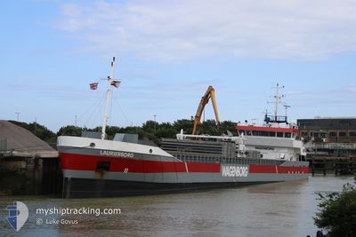
LAURIERBORG
General Cargo

Current Trip
| Time Travelled | 2 days |
|---|---|
| Remaining Time | 14 h, 40 mins |
| Distance Travelled | 711.38 nm |
| Remaining Distance | 179.96 nm |
| AVG Speed | 10.2 Knots |
| MAX Speed | 10.2 Knots |
| AVG Wind | 13.1 knots |
| MAX Wind | 23 knots |
| MIN Temp | 6.1°C / 42.98°F |
| MAX Temp | 11.3°C / 52.34°F |
| Dybgang | 3.4 m |
| Position Modtaget | 23 m siden |
Current Position
| Longitude | --- |
|---|---|
| Latitude | --- |
| Status | Under way using engine |
| Fart | 11.2 Knots |
| Kurs | 45° |
| Område | North Sea |
| Station | T-AIS |
| Position Modtaget | 23 m siden |
Information
The current position of LAURIERBORG is in North Sea with coordinates 52.28620° / 3.33986° as reported on 2025-03-29 16:57 by AIS to our vessel tracker app. The vessel's current speed is 11.2 Knots and is heading at the port of DELFZIJL. The estimated time of arrival as calculated by MyShipTracking vessel tracking app is 2025-03-30 10:00 LT
The vessel LAURIERBORG (IMO: 9279070, MMSI: 246924000) is a General Cargo that was built in 2006 ( 19 år gamle ). It's sailing under the flag of [NL] Netherlands.
In this page you can find informations about the vessels current position, last detected port calls, and current voyage information. If the vessels is not in coverage by AIS you will find the latest position.
The current position of LAURIERBORG is detected by our AIS receivers and we are not responsible for the reliability of the data. The last position was recorded while the vessel was in Coverage by the Ais receivers of our vessel tracking app.
The current draught of LAURIERBORG as reported by AIS is 3.4 meters
Weather
| Temperature | 7.9°C / 46.22°F |
|---|---|
| Wind Speed | 12 knots |
| Direction | 219° SW |
| Pressure | 1020.3 hPa |
| Humidity | 85.2 % |
| Cloud Coverage | 9 % |

Featured Company
Last Port Calls
| Port | Arrival | Departure | Time In Port |
|---|---|---|---|
| 2025-03-26 20:45 | 2025-03-26 21:15 | 29 m | |
| 2025-03-26 19:55 | 2025-03-26 20:15 | 20 m | |
| 2025-03-26 00:47 | 2025-03-26 19:11 | 18 h | |
| 2025-03-25 23:38 | 2025-03-25 23:58 | 19 m | |
| 2025-03-25 22:30 | 2025-03-25 23:15 | 44 m | |
| 2025-03-23 14:52 | 2025-03-24 15:20 | 1 d | |
| 2025-03-22 13:36 | 2025-03-22 14:06 | 30 m | |
| 2025-03-21 03:33 | 2025-03-22 13:18 | 1 d | |
| 2025-03-21 02:34 | 2025-03-21 03:11 | 37 m | |
| 2025-03-14 05:12 | 2025-03-18 06:32 | 4 d |
Last Trips
| Origin | Departure | Destination | Arrival | Distance | |
|---|---|---|---|---|---|
| 2025-03-26 20:15 | 2025-03-26 20:45 | 1.93 nm | |||
| 2025-03-26 19:11 | 2025-03-26 19:55 | 4.55 nm | |||
| 2025-03-25 23:58 | 2025-03-26 00:47 | 4.76 nm | |||
| 2025-03-25 23:15 | 2025-03-25 23:38 | 1.97 nm | |||
| 2025-03-24 15:20 | 2025-03-25 22:30 | 242.22 nm | |||
| 2025-03-22 14:06 | 2025-03-23 14:52 | 242.31 nm | |||
| 2025-03-22 13:18 | 2025-03-22 13:36 | 2.00 nm | |||
| 2025-03-21 03:11 | 2025-03-21 03:33 | 1.49 nm | |||
| 2025-03-18 06:32 | 2025-03-21 02:34 | 588.62 nm | |||
| 2025-03-12 18:13 | 2025-03-14 05:12 | 59.23 nm |
Events
| Tid | Hændelsen | Detaljer | Position / Dest | Info |
|---|---|---|---|---|
| 2025-03-29 16:59 | Status er ændret | Default Under way using engine |
52.29129 / 3.34822
DELFZIJL
|
Fart: 11.2 kn Kurs: 45° |
| 2025-03-29 16:57 | Status er ændret | Under way using engine Default |
52.28620 / 3.33986
DELFZIJL
|
Fart: 11.3 kn Kurs: 43° |
| 2025-03-29 16:50 | Status er ændret | Default Under way using engine |
52.27145 / 3.31589
DELFZIJL
|
Fart: 11.3 kn Kurs: 43.4° |
| 2025-03-29 16:45 | Status er ændret | Under way using engine Default |
52.26080 / 3.29966
DELFZIJL
|
Fart: 11.3 kn Kurs: 43° |
| 2025-03-29 16:38 | Status er ændret | Default Under way using engine |
52.24356 / 3.27343
DELFZIJL
|
Fart: 11.3 kn Kurs: 42.5° |
| 2025-03-29 16:35 | Status er ændret | Under way using engine Default |
52.23655 / 3.26291
DELFZIJL
|
Fart: 11.5 kn Kurs: 42° |
| 2025-03-29 16:12 | Status er ændret | Default Under way using engine |
52.18386 / 3.18336
DELFZIJL
|
Fart: 11.6 kn Kurs: 42.5° |
| 2025-03-29 16:10 | Status er ændret | Under way using engine Default |
52.17793 / 3.17449
DELFZIJL
|
Fart: 11.6 kn Kurs: 42° |
| 2025-03-29 16:00 | Status er ændret | Default Under way using engine |
52.15545 / 3.14061
DELFZIJL
|
Fart: 11.7 kn Kurs: 42° |
| 2025-03-29 15:54 | Status er ændret | Under way using engine Default |
52.14002 / 3.11732
DELFZIJL
|
Fart: 11.8 kn Kurs: 42° |