

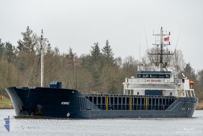
HENRIKE
General Cargo

Current Trip
| Time Travelled | 11 h, 35 mins |
|---|---|
| Remaining Time | --- |
| Distance Travelled | 68.40 nm |
| Remaining Distance | --- |
| AVG Speed | 6.7 Knots |
| MAX Speed | 10 Knots |
| AVG Wind | 21 knots |
| MAX Wind | 26 knots |
| MIN Temp | 6.5°C / 43.7°F |
| MAX Temp | 10.3°C / 50.54°F |
| Dybgang | 3.4 m |
| Position Modtaget | 4 m siden |
Current Position
| Longitude | --- |
|---|---|
| Latitude | --- |
| Status | At anchor |
| Fart | |
| Kurs | 74° |
| Område | North Sea |
| Station | T-AIS |
| Position Modtaget | 4 m siden |
Information
The current position of HENRIKE is in North Sea with coordinates 54.43377° / 8.81384° as reported on 2025-03-22 11:09 by AIS to our vessel tracker app. The vessel's current speed is 0 Knots
The vessel HENRIKE (IMO: 9218222, MMSI: 218858000) is a General Cargo that was built in 2000 ( 25 år gamle ). It's sailing under the flag of [DE] Germany.
In this page you can find informations about the vessels current position, last detected port calls, and current voyage information. If the vessels is not in coverage by AIS you will find the latest position.
The current position of HENRIKE is detected by our AIS receivers and we are not responsible for the reliability of the data. The last position was recorded while the vessel was in Coverage by the Ais receivers of our vessel tracking app.
The current draught of HENRIKE as reported by AIS is 3.4 meters
Weather
| Temperature | 10.5°C / 50.9°F |
|---|---|
| Wind Speed | 22 knots |
| Direction | 106° ESE |
| Pressure | 1014.3 hPa |
| Humidity | 59.2 % |
| Cloud Coverage | 5 % |


Featured Company
Last Port Calls
| Port | Arrival | Departure | Time In Port |
|---|---|---|---|
| 2025-03-21 23:19 | 2025-03-22 00:38 | 1 h | |
| 2025-03-19 20:58 | 2025-03-20 20:58 | 1 d | |
| 2025-03-17 06:34 | 2025-03-18 02:04 | 19 h | |
| 2025-03-13 23:51 | 2025-03-14 14:29 | 14 h | |
| 2025-03-10 08:40 | 2025-03-11 15:34 | 1 d | |
| 2025-03-07 14:49 | 2025-03-08 11:29 | 20 h | |
| 2025-03-05 09:55 | 2025-03-06 03:12 | 17 h | |
| 2025-03-02 13:40 | 2025-03-03 19:58 | 1 d | |
| 2025-02-27 23:58 | 2025-03-02 01:09 | 2 d | |
| 2025-02-21 20:08 | 2025-02-22 17:58 | 21 h |
Last Trips
| Origin | Departure | Destination | Arrival | Distance | |
|---|---|---|---|---|---|
| 2025-03-20 20:58 | 2025-03-21 23:19 | 222.77 nm | |||
| 2025-03-18 02:04 | 2025-03-19 20:58 | 285.12 nm | |||
| 2025-03-14 14:29 | 2025-03-17 06:34 | 524.98 nm | |||
| 2025-03-11 15:34 | 2025-03-13 23:51 | 552.25 nm | |||
| 2025-03-08 11:29 | 2025-03-10 08:40 | 386.90 nm | |||
| 2025-03-06 03:12 | 2025-03-07 14:49 | 301.53 nm | |||
| 2025-03-03 19:58 | 2025-03-05 09:55 | 313.68 nm | |||
| 2025-03-02 01:09 | 2025-03-02 13:40 | 111.95 nm | |||
| 2025-02-22 17:58 | 2025-02-27 23:58 | 601.83 nm | |||
| 2025-02-19 23:48 | 2025-02-21 20:08 | 378.73 nm |
Events
| Tid | Hændelsen | Detaljer | Position / Dest | Info |
|---|---|---|---|---|
| 2025-03-22 09:51 | Status er ændret | At anchor Default |
54.43438 / 8.81391
DEHUS
|
Fart: 0.2 kn Kurs: 95° |
| 2025-03-22 09:48 | Status er ændret | Default At anchor |
54.43420 / 8.81388
DEHUS
|
Fart: 0.2 kn Kurs: 107° |
| 2025-03-22 09:42 | Status er ændret | At anchor Under way using engine |
54.43433 / 8.81393
DEHUS
|
Fart: 0.2 kn Kurs: 111° |
| 2025-03-22 09:32 | STOP Sejllads | 3.88 nm, South of NORDSTRAND |
54.43423 / 8.81586
DEHUS
|
Fart: 0.3 kn Kurs: 113° |
| 2025-03-22 06:28 | Dybgangen er ændret | 3.4 3.5 |
54.30675 / 8.32152
DEHUS
|
Fart: 7.5 kn Kurs: 19.6° |
| 2025-03-22 06:24 | Status er ændret | Under way using engine Default |
54.29954 / 8.31988
DEHUS
|
Fart: 8.4 kn Kurs: 347° |
| 2025-03-22 06:14 | Status er ændret | Default Under way using engine |
54.27651 / 8.32979
DEHUS
|
Fart: 6.7 kn Kurs: 345.1° |
| 2025-03-22 06:01 | Status er ændret | Under way using engine Default |
54.25337 / 8.34073
DEHUS
|
Fart: 6.3 kn Kurs: 344° |
| 2025-03-22 05:54 | Status er ændret | Default Under way using engine |
54.24104 / 8.34655
DEHUS
|
Fart: 6 kn Kurs: 344.2° |
| 2025-03-22 05:28 | Status er ændret | Under way using engine Default |
54.20029 / 8.36561
DEHUS
|
Fart: 5.8 kn Kurs: 347° |