
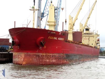
FEDERAL HUDSON
Bulk Carrier
Current Trip
| Time Travelled | 5 days |
|---|---|
| Remaining Time | --- |
| Distance Travelled | 234.79 nm |
| Remaining Distance | --- |
| AVG Speed | 12.6 Knots |
| MAX Speed | 14.1 Knots |
| AVG Wind | 7.1 knots |
| MAX Wind | 14 knots |
| MIN Temp | 12.1°C / 53.78°F |
| MAX Temp | 26°C / 78.8°F |
| Dybgang | 6 m |
| Position Modtaget | 5 d siden |
Current Position
| Longitude | -83.46622° |
|---|---|
| Latitude | 45.52255° |
| Status | Under way using engine |
| Fart | 13.6 Knots |
| Kurs | 324° |
| Område | Gulf of St-Lawrence |
| Station | T-AIS |
| Position Modtaget | 5 d siden |
Info
Information
The current position of FEDERAL HUDSON is in Gulf of St-Lawrence with coordinates 45.52255° / -83.46622° as reported on 2024-08-26 03:42 by AIS to our vessel tracker app. The vessel's current speed is 13.6 Knots and is heading at the port of DETROIT. The estimated time of arrival as calculated by MyShipTracking vessel tracking app is 2024-08-25 06:00 LT
The vessel FEDERAL HUDSON (IMO: 9205902, MMSI: 538006779) is a Bulk Carrier that was built in 2000 ( 24 år gamle ). It's sailing under the flag of [MH] Marshall Is.
In this page you can find informations about the vessels current position, last detected port calls, and current voyage information. If the vessels is not in coverage by AIS you will find the latest position.
The current position of FEDERAL HUDSON is detected by our AIS receivers and we are not responsible for the reliability of the data. The last position was recorded while the vessel was in Coverage by the Ais receivers of our vessel tracking app.
The current draught of FEDERAL HUDSON as reported by AIS is 6 meters
Weather
| Temperature | 15.4°C / 59.72°F |
|---|---|
| Wind Speed | 6 knots |
| Direction | 351° N |
| Pressure | 1006.1 hPa |
| Humidity | 91.6 % |
| Cloud Coverage | 100 % |
Featured Company
Last Port Calls
| Port | Arrival | Departure | Time In Port |
|---|---|---|---|
| 2024-08-26 07:30 | 2024-08-26 08:01 | 30 m | |
| 2024-08-25 01:01 | 2024-08-25 06:43 | 5 h | |
| 2024-08-18 12:22 | 2024-08-24 08:13 | 5 d | |
| 2024-08-17 22:00 | 2024-08-17 23:26 | 1 h | |
| 2024-08-08 01:42 | 2024-08-17 18:50 | 9 d | |
| 2024-08-06 12:35 | 2024-08-06 16:02 | 3 h | |
| 2024-06-25 05:22 | 2024-07-11 12:03 | 16 d | |
| 2024-06-05 10:22 | 2024-06-06 16:31 | 1 d | |
| 2024-06-02 08:49 |
Most Visited Ports (Last year)
| Port | Arrivals | |
|---|---|---|
| 5 | ||
| 5 | ||
| 5 | ||
| 4 | ||
| 3 | ||
| 2 |
Last Trips
| Origin | Departure | Destination | Arrival | Distance | |
|---|---|---|---|---|---|
| 2024-08-25 06:43 | 2024-08-26 07:30 | 285.88 nm | |||
| 2024-08-24 08:13 | 2024-08-25 01:01 | 221.29 nm | |||
| 2024-08-17 23:26 | 2024-08-18 12:22 | 40.43 nm | |||
| 2024-08-17 18:50 | 2024-08-17 22:00 | 27.35 nm | |||
| 2024-08-06 16:02 | 2024-08-08 01:42 | 315.44 nm | |||
| 2024-07-11 12:03 | 2024-08-06 12:35 | 6752.18 nm | |||
| 2024-06-06 16:31 | 2024-06-25 05:22 | 4548.43 nm | |||
| 2024-06-02 08:49 | 2024-06-05 10:22 | 684.63 nm |
Events
| Tid | Hændelsen | Detaljer | Position / Dest | Info |
|---|---|---|---|---|
| 2024-08-27 05:59 | STOP Sejllads | 0.84 nm, East of THUNDER BAY |
48.40538 / -89.18626
DETROIT
|
Fart: 0.3 kn Kurs: 326° |
| 2024-08-26 12:01 | Afsejlet fra sidste havn |
|
46.46032 / -84.47610
DETROIT
|
Fart: 10.1 kn Kurs: 256° |
| 2024-08-26 11:47 | START Sejllads |
46.50250 / -84.36043
[CA] SAULT STE MARIE
|
Fart: 3.1 kn Kurs: 267° |
|
| 2024-08-26 11:31 | STOP Sejllads |
46.50312 / -84.35128
[CA] SAULT STE MARIE
|
Fart: Kurs: 266° |
|
| 2024-08-26 11:30 | Skibe i havn |
|
46.50312 / -84.35128
[CA] SAULT STE MARIE
|
Fart: 1 kn Kurs: 266° |
| 2024-08-26 03:43 | Status er ændret | Default Under way using engine |
45.52312 / -83.46678
DETROIT
|
Fart: 13.6 kn Kurs: 324° |
| 2024-08-26 03:42 | Udenfor Dækning |
45.52255 / -83.46622
Gulf of St-Lawrence
|
Fart: 13.6 kn Kurs: 324° |
|
| 2024-08-26 03:08 | Status er ændret | Under way using engine Default |
45.41647 / -83.35855
DETROIT
|
Fart: 13.8 kn Kurs: 323° |
| 2024-08-26 03:07 | Status er ændret | Default Under way using engine |
45.41120 / -83.35304
DETROIT
|
Fart: 13.9 kn Kurs: 324° |
| 2024-08-26 02:51 | Status er ændret | Under way using engine Default |
45.36173 / -83.30215
DETROIT
|
Fart: 13.9 kn Kurs: 323° |