

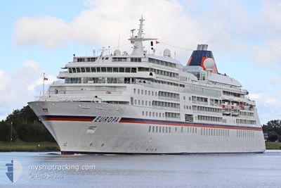
EUROPA
Passengers Ship

Current Trip
| Time Travelled | 2 days |
|---|---|
| Remaining Time | --- |
| Distance Travelled | 872.83 nm |
| Remaining Distance | --- |
| AVG Speed | 14.9 Knots |
| MAX Speed | 18.5 Knots |
| AVG Wind | 5.9 knots |
| MAX Wind | 12.5 knots |
| MIN Temp | 18.8°C / 65.84°F |
| MAX Temp | 23°C / 73.4°F |
| Dybgang | 6.3 m |
| Position Modtaget | 6 d siden |
Current Position
| Longitude | --- |
|---|---|
| Latitude | --- |
| Status | Under way using engine |
| Fart | 14.1 Knots |
| Kurs | 300.1° |
| Område | South Atlantic Ocean |
| Station | T-AIS |
| Position Modtaget | 6 d siden |
Information
The current position of EUROPA is in South Atlantic Ocean with coordinates -33.61218° / 18.03380° as reported on 2025-03-15 18:14 by AIS to our vessel tracker app. The vessel's current speed is 14.1 Knots and is heading at the port of LUDERITZ. The estimated time of arrival as calculated by MyShipTracking vessel tracking app is 2025-03-17 04:30 LT
The vessel EUROPA (IMO: 9183855, MMSI: 215767000) is a Passengers Ship that was built in 1999 ( 26 år gamle ). It's sailing under the flag of [MT] Malta.
In this page you can find informations about the vessels current position, last detected port calls, and current voyage information. If the vessels is not in coverage by AIS you will find the latest position.
The current position of EUROPA is detected by our AIS receivers and we are not responsible for the reliability of the data. The last position was recorded while the vessel was in Coverage by the Ais receivers of our vessel tracking app.
The current draught of EUROPA as reported by AIS is 6.3 meters
Weather
| Temperature | 22.2°C / 71.96°F |
|---|---|
| Wind Speed | 6 knots |
| Direction | 177° S |
| Pressure | 1015.4 hPa |
| Humidity | 70.6 % |
| Cloud Coverage | 96 % |


Featured Company
Last Port Calls
| Port | Arrival | Departure | Time In Port |
|---|---|---|---|
| 2025-03-18 07:25 | 2025-03-19 16:33 | 1 d | |
| 2025-03-17 05:03 | 2025-03-17 13:56 | 8 h | |
| 2025-03-13 15:58 | 2025-03-15 16:16 | 2 d | |
| 2025-03-10 05:00 | 2025-03-11 15:12 | 1 d | |
| 2025-03-07 07:54 | 2025-03-08 16:52 | 1 d | |
| 2025-03-06 05:00 | 2025-03-06 13:04 | 8 h | |
| 2025-03-03 03:59 | 2025-03-03 14:08 | 10 h | |
| 2025-03-01 04:16 | 2025-03-01 14:58 | 10 h | |
| 2025-02-25 18:15 | 2025-02-26 12:56 | 18 h | |
| 2025-02-17 02:16 | 2025-02-17 16:48 | 14 h |
Most Visited Ports (Last year)
| Port | Arrivals | |
|---|---|---|
| 5 | ||
| 4 | ||
| 3 | ||
| 3 | ||
| 3 | ||
| 3 |
Last Trips
| Origin | Departure | Destination | Arrival | Distance | |
|---|---|---|---|---|---|
| 2025-03-17 15:56 | 2025-03-18 09:25 | 254.54 nm | |||
| 2025-03-15 18:16 | 2025-03-17 07:03 | 492.55 nm | |||
| 2025-03-11 17:12 | 2025-03-13 17:58 | 592.64 nm | |||
| 2025-03-08 18:52 | 2025-03-10 07:00 | 412.74 nm | |||
| 2025-03-06 15:04 | 2025-03-07 09:54 | 340.96 nm | |||
| 2025-03-03 17:08 | 2025-03-06 07:00 | 822.97 nm | |||
| 2025-03-01 17:58 | 2025-03-03 06:59 | 460.69 nm | |||
| 2025-02-26 16:56 | 2025-03-01 07:16 | 668.36 nm | |||
| 2025-02-17 19:48 | 2025-02-25 22:15 | 2083.28 nm | |||
| 2025-02-16 17:59 | 2025-02-17 05:16 | 149.03 nm |
Events
| Tid | Hændelsen | Detaljer | Position / Dest | Info |
|---|---|---|---|---|
| 2025-03-19 16:33 | Afsejlet fra sidste havn |
|
-22.92033 / 14.49742
NALUD
|
Fart: 9.5 kn Kurs: 2° |
| 2025-03-19 16:21 | START Sejllads |
-22.94737 / 14.49652
[NA] WALVIS BAY
|
Fart: 3.7 kn Kurs: 358° |
|
| 2025-03-18 07:45 | STOP Sejllads |
-22.94962 / 14.49783
[NA] WALVIS BAY
|
Fart: 0.1 kn Kurs: 48° |
|
| 2025-03-18 07:25 | Skibe i havn |
|
-22.93662 / 14.49657
[NA] WALVIS BAY
|
Fart: 10.7 kn Kurs: 184° |
| 2025-03-17 13:56 | START Sejllads | 0.57 nm, North of LUDERITZ |
-26.62812 / 15.15942
NALUD
|
Fart: 6.2 kn Kurs: 349° |
| 2025-03-17 13:56 | Afsejlet fra sidste havn |
|
-26.62812 / 15.15942
NALUD
|
Fart: 0.8 kn Kurs: 16° |
| 2025-03-17 05:20 | STOP Sejllads |
-26.63893 / 15.15477
[NA] LUDERITZ
|
Fart: Kurs: 14° |
|
| 2025-03-17 05:03 | Skibe i havn |
|
-26.63427 / 15.15730
[NA] LUDERITZ
|
Fart: 3.9 kn Kurs: 16° |
| 2025-03-15 18:21 | Status er ændret | Default Under way using engine |
-33.60030 / 18.00702
NALUD
|
Fart: 14.1 kn Kurs: 300.1° |
| 2025-03-15 18:14 | Udenfor Dækning |
-33.61218 / 18.03380
South Atlantic Ocean
NALUD
|
Fart: 14.1 kn Kurs: 300.1° |