
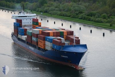
ELBWAVE
Container Ship
Current Trip
| Time Travelled | 1 day |
|---|---|
| Remaining Time | 13 h, 51 mins |
| Distance Travelled | 567.36 nm |
| Remaining Distance | 190.74 nm |
| AVG Speed | 13.7 Knots |
| MAX Speed | 18 Knots |
| AVG Wind | 7.9 knots |
| MAX Wind | 14.9 knots |
| MIN Temp | 6.1°C / 42.98°F |
| MAX Temp | 9.9°C / 49.82°F |
| Dybgang | 8.5 m |
| Position Modtaget | 1 m siden |
Current Position
| Longitude | 11.53593° |
|---|---|
| Latitude | 54.50126° |
| Status | Under way using engine |
| Fart | 13.1 Knots |
| Kurs | 298° |
| Område | Baltic Sea |
| Station | T-AIS |
| Position Modtaget | 1 m siden |
Info
Information
The current position of ELBWAVE is in Baltic Sea with coordinates 54.50126° / 11.53593° as reported on 2024-05-05 07:20 by AIS to our vessel tracker app. The vessel's current speed is 13.1 Knots and is heading at the port of BREMERHAVEN. The estimated time of arrival as calculated by MyShipTracking vessel tracking app is 2024-05-05 21:13 LT
The vessel ELBWAVE (IMO: 9504035, MMSI: 209276000) is a Container Ship that was built in 2011 ( 13 år gamle ). It's sailing under the flag of [CY] Cyprus.
In this page you can find informations about the vessels current position, last detected port calls, and current voyage information. If the vessels is not in coverage by AIS you will find the latest position.
The current position of ELBWAVE is detected by our AIS receivers and we are not responsible for the reliability of the data. The last position was recorded while the vessel was in Coverage by the Ais receivers of our vessel tracking app.
The current draught of ELBWAVE as reported by AIS is 8.5 meters
Weather
| Temperature | 9.8°C / 49.64°F |
|---|---|
| Wind Speed | 13 knots |
| Direction | 116° ESE |
| Pressure | 1006.8 hPa |
| Humidity | 98.9 % |
| Cloud Coverage | 100 % |
Featured Company
Last Port Calls
| Port | Arrival | Departure | Time In Port |
|---|---|---|---|
| 2024-05-02 23:19 | 2024-05-03 14:02 | 14 h | |
| 2024-04-30 21:19 | 2024-05-01 05:54 | 8 h | |
| 2024-04-26 19:56 | 2024-04-29 04:09 | 2 d | |
| 2024-04-26 02:06 | 2024-04-26 10:13 | 8 h | |
| 2024-04-22 10:50 | 2024-04-23 16:08 | 1 d | |
| 2024-04-21 03:57 | 2024-04-21 16:06 | 12 h | |
| 2024-04-19 10:23 | 2024-04-19 23:36 | 13 h | |
| 2024-04-16 20:27 | 2024-04-17 21:17 | 1 d | |
| 2024-04-15 20:11 | 2024-04-16 12:28 | 16 h | |
| 2024-04-13 15:00 | 2024-04-14 00:48 | 9 h |
Most Visited Ports (Last year)
| Port | Arrivals | |
|---|---|---|
| 30 | ||
| 30 | ||
| 14 | ||
| 13 | ||
| 9 | ||
| 9 |
Last Trips
| Origin | Departure | Destination | Arrival | Distance | |
|---|---|---|---|---|---|
| 2024-05-01 08:54 | 2024-05-03 01:19 | 367.04 nm | |||
| 2024-04-29 06:09 | 2024-05-01 00:19 | 493.59 nm | |||
| 2024-04-26 12:13 | 2024-04-26 21:56 | 114.57 nm | |||
| 2024-04-23 18:08 | 2024-04-26 04:06 | 757.87 nm | |||
| 2024-04-21 18:06 | 2024-04-22 12:50 | 271.19 nm | |||
| 2024-04-20 01:36 | 2024-04-21 05:57 | 308.56 nm | |||
| 2024-04-17 23:17 | 2024-04-19 12:23 | 445.64 nm | |||
| 2024-04-16 14:28 | 2024-04-16 22:27 | 113.70 nm | |||
| 2024-04-14 02:48 | 2024-04-15 22:11 | 489.19 nm | |||
| 2024-04-12 13:07 | 2024-04-13 17:00 | 435.64 nm |
Events
| Tid | Hændelsen | Detaljer | Position / Dest | Info |
|---|---|---|---|---|
| 2024-05-05 05:43 | Ændre havområde | Danish part of the Baltic Sea German part of the Baltic Sea |
54.44150 / 12.13566
Baltic Sea
DEBRV
|
Fart: 13.5 kn Kurs: 265° |
| 2024-05-05 05:22 | Ændre havområde | German part of the Baltic Sea Danish part of the Baltic Sea |
54.49461 / 12.21289
Baltic Sea
DEBRV
|
Fart: 13.5 kn Kurs: 194.3° |
| 2024-05-05 04:19 | Ændre havområde | Danish part of the Baltic Sea German part of the Baltic Sea |
54.67958 / 12.43326
Baltic Sea
DEBRV
|
Fart: 13.5 kn Kurs: 240.6° |
| 2024-05-05 03:55 | Ændre havområde | German part of the Baltic Sea Danish part of the Baltic Sea |
54.71847 / 12.57146
Baltic Sea
DEBRV
|
Fart: 13.4 kn Kurs: 234.1° |
| 2024-05-05 02:58 | Ændre havområde | Danish part of the Baltic Sea German part of the Baltic Sea |
54.81956 / 12.89172
Baltic Sea
DEBRV
|
Fart: 13.5 kn Kurs: 249.6° |
| 2024-05-05 00:31 | Ændre havområde | German part of the Baltic Sea Swedish part of the Baltic Sea |
55.01557 / 13.79784
Baltic Sea
DEBRV
|
Fart: 13.8 kn Kurs: 256° |
| 2024-05-04 21:16 | Ændre havområde | Swedish part of the Baltic Sea Danish part of the Kattegat |
55.49062 / 14.73269
Baltic Sea
DEBRV
|
Fart: 13.7 kn Kurs: 240.2° |
| 2024-05-04 19:50 | Ændre havområde | Danish part of the Kattegat Swedish part of the Baltic Sea |
55.63903 / 15.24851
Kattegat
DEBRV
|
Fart: 13.7 kn Kurs: 239.8° |
| 2024-05-04 13:50 | Status er ændret | Under way using engine Default |
56.50257 / 16.97960
DEBRV
|
Fart: 13.6 kn Kurs: 201° |
| 2024-05-04 13:44 | Indenfor Dækning |
56.50257 / 16.97960
Baltic Sea
DEBRV
|
Fart: 13.6 kn Kurs: 201.5° |