
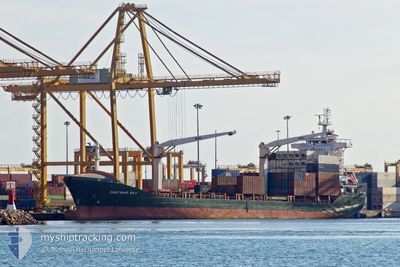
CONTSHIP RAY
General Cargo
Current Trip
| Time Travelled | 12 h, 35 mins |
|---|---|
| Remaining Time | 1 day |
| Distance Travelled | 62.67 nm |
| Remaining Distance | 651.93 nm |
| AVG Speed | 11.3 Knots |
| MAX Speed | 15 Knots |
| AVG Wind | 15.6 knots |
| MAX Wind | 26 knots |
| MIN Temp | 9.7°C / 49.46°F |
| MAX Temp | 16.6°C / 61.88°F |
| Dybgang | 6.7 m |
| Position Modtaget | 2 m siden |
Current Position
| Longitude | --- |
|---|---|
| Latitude | --- |
| Status | Under way using engine |
| Fart | 11.6 Knots |
| Kurs | 84.1° |
| Område | Alboran Sea |
| Station | T-AIS |
| Position Modtaget | 2 m siden |
Info
Information
The current position of CONTSHIP RAY is in Alboran Sea with coordinates 36.12030° / -4.26045° as reported on 2025-03-10 16:57 by AIS to our vessel tracker app. The vessel's current speed is 11.6 Knots and is heading at the port of MARSEILLE. The estimated time of arrival as calculated by MyShipTracking vessel tracking app is 2025-03-12 13:39 LT
The vessel CONTSHIP RAY (IMO: 9388338, MMSI: 636017852) is a General Cargo that was built in 2008 ( 17 år gamle ). It's sailing under the flag of [LR] Liberia.
In this page you can find informations about the vessels current position, last detected port calls, and current voyage information. If the vessels is not in coverage by AIS you will find the latest position.
The current position of CONTSHIP RAY is detected by our AIS receivers and we are not responsible for the reliability of the data. The last position was recorded while the vessel was in Coverage by the Ais receivers of our vessel tracking app.
The current draught of CONTSHIP RAY as reported by AIS is 6.7 meters
Weather
| Temperature | 16.5°C / 61.7°F |
|---|---|
| Wind Speed | 22 knots |
| Direction | 253° WSW |
| Pressure | 1005.3 hPa |
| Humidity | 73.8 % |
| Cloud Coverage | 10 % |
Featured Company
Last Port Calls
| Port | Arrival | Departure | Time In Port |
|---|---|---|---|
| 2025-03-09 17:24 | 2025-03-10 04:24 | 10 h | |
| 2025-03-03 16:20 | 2025-03-08 13:21 | 4 d | |
| 2025-03-01 03:25 | 2025-03-01 18:57 | 15 h | |
| 2025-02-26 18:39 | 2025-02-27 10:21 | 15 h | |
| 2025-02-21 11:57 | 2025-02-25 09:38 | 3 d | |
| 2025-02-19 16:11 | 2025-02-20 12:35 | 20 h | |
| 2025-02-16 13:35 | 2025-02-17 11:21 | 21 h | |
| 2025-02-10 17:49 | 2025-02-13 13:29 | 2 d | |
| 2025-02-04 06:54 | 2025-02-06 10:52 | 2 d | |
| 2025-01-29 09:09 | 2025-01-30 02:47 | 17 h |
Last Trips
| Origin | Departure | Destination | Arrival | Distance | |
|---|---|---|---|---|---|
| 2025-03-08 14:21 | 2025-03-09 18:24 | 210.14 nm | |||
| 2025-03-01 19:57 | 2025-03-03 17:20 | 193.04 nm | |||
| 2025-02-27 11:21 | 2025-03-01 04:25 | 411.70 nm | |||
| 2025-02-25 10:38 | 2025-02-26 19:39 | 357.18 nm | |||
| 2025-02-20 13:35 | 2025-02-21 12:57 | 202.65 nm | |||
| 2025-02-17 12:21 | 2025-02-19 17:11 | 544.30 nm | |||
| 2025-02-13 14:29 | 2025-02-16 14:35 | 676.27 nm | |||
| 2025-02-06 11:52 | 2025-02-10 18:49 | 54.14 nm | |||
| 2025-01-30 03:47 | 2025-02-04 07:54 | 296.05 nm | |||
| 2025-01-27 18:37 | 2025-01-29 10:09 | 359.54 nm |
Events
| Tid | Hændelsen | Detaljer | Position / Dest | Info |
|---|---|---|---|---|
| 2025-03-10 16:45 | Status er ændret | Under way using engine Default |
36.11575 / -4.30970
FRMRS
|
Fart: 12.3 kn Kurs: 83° |
| 2025-03-10 16:39 | Status er ændret | Default Under way using engine |
36.11353 / -4.33237
FRMRS
|
Fart: 13 kn Kurs: 83.2° |
| 2025-03-10 14:16 | Ændre havområde | Spanish part of the Alboran Sea Gibraltarian part of the Alboran Sea |
36.05533 / -5.02461
Alboran Sea
FRMRS
|
Fart: 14.1 kn Kurs: 101.7° |
| 2025-03-10 13:37 | Fundet i havområde | Gibraltarian part of the Alboran Sea |
36.06137 / -5.21458
Alboran Sea
FRMRS
|
Fart: 13.3 kn Kurs: 90° |
| 2025-03-10 13:24 | ETA er ændret | 2025/03/12 16:30 2025/03/13 00:00 |
36.06055 / -5.28018
FRMRS
|
Fart: 13.3 kn Kurs: 88.4° |
| 2025-03-10 12:49 | Dybgangen er ændret | 6.7 6.4 |
36.13219 / -5.39594
FRMRS
|
Fart: 12.9 kn Kurs: 153° |
| 2025-03-10 12:49 | Destination er ændret | FRMRS ESALG |
36.13219 / -5.39594
FRMRS
|
Fart: 12.9 kn Kurs: 153° |
| 2025-03-10 12:49 | ETA er ændret | 2025/03/13 00:00 2025/03/09 03:00 |
36.13219 / -5.39594
FRMRS
|
Fart: 12.9 kn Kurs: 153° |
| 2025-03-10 12:48 | Ændre havområde | Gibraltarian part of the Strait of Gibraltar Spanish part of the Strait of Gibraltar |
36.13267 / -5.39623
Strait of Gibraltar
|
Fart: 12.9 kn Kurs: 153° |
| 2025-03-10 12:29 | START Sejllads | 0.6 nm, South of PALMONES |
36.16613 / -5.42432
ESALG
|
Fart: 6.3 kn Kurs: 163.2° |