

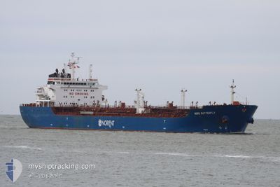
CLOTILDE
Oil/Chemical Tanker

Current Trip
| Trip Time | 4 days |
|---|---|
| Trip Distance | 208.84 nm |
| AVG Speed | 8.9 Knots |
| MAX Speed | 13.1 Knots |
| Dybgang | 10 m |
| AVG Wind | 5.1 knots |
| MAX Wind | 15.6 knots |
| MIN Temp | 11.2°C / 52.16°F |
| MAX Temp | 18.6°C / 65.48°F |
| Position Modtaget | 3 d siden |
Current Position
| Longitude | --- |
|---|---|
| Latitude | --- |
| Status | Under way using engine |
| Fart | 1.3 Knots |
| Kurs | 212° |
| Område | Mediterranean Sea - Western Basin |
| Station | T-AIS |
| Position Modtaget | 3 d siden |
Information
The current position of CLOTILDE is in Mediterranean Sea - Western Basin with coordinates 36.76415° / 3.07511° as reported on 2025-02-16 16:46 by AIS to our vessel tracker app. The vessel's current speed is 1.3 Knots and is currently inside the port of ALGER.
The vessel CLOTILDE (IMO: 9448310, MMSI: 215910000) is a Oil/Chemical Tanker that was built in 2008 ( 17 år gamle ). It's sailing under the flag of [MT] Malta.
In this page you can find informations about the vessels current position, last detected port calls, and current voyage information. If the vessels is not in coverage by AIS you will find the latest position.
The current position of CLOTILDE is detected by our AIS receivers and we are not responsible for the reliability of the data. The last position was recorded while the vessel was in Coverage by the Ais receivers of our vessel tracking app.
The current draught of CLOTILDE as reported by AIS is 10 meters
Weather
| Temperature | 14.6°C / 58.28°F |
|---|---|
| Wind Speed | 1 knots |
| Direction | 111° ESE |
| Pressure | 1023.1 hPa |
| Humidity | 64.6 % |
| Cloud Coverage | 79 % |


Featured Company
Last Port Calls
| Port | Arrival | Departure | Time In Port |
|---|---|---|---|
| 2025-02-16 17:35 | |||
| 2025-02-10 13:11 | 2025-02-11 18:31 | 1 d | |
| 2025-02-03 17:14 | 2025-02-07 17:14 | 3 d | |
| 2025-01-31 17:13 | 2025-02-02 06:50 | 1 d | |
| 2025-01-26 22:33 | 2025-01-30 11:47 | 3 d | |
| 2025-01-24 12:29 | 2025-01-25 15:20 | 1 d | |
| 2025-01-20 11:38 | 2025-01-22 17:24 | 2 d | |
| 2025-01-16 15:44 | 2025-01-17 17:55 | 1 d | |
| 2025-01-09 14:47 | 2025-01-14 11:58 | 4 d | |
| 2025-01-07 13:12 | 2025-01-08 17:03 | 1 d |
Last Trips
| Origin | Departure | Destination | Arrival | Distance | |
|---|---|---|---|---|---|
| 2025-02-11 18:31 | 2025-02-16 17:35 | 208.84 nm | |||
| 2025-02-07 17:14 | 2025-02-10 13:11 | 394.15 nm | |||
| 2025-02-02 06:50 | 2025-02-03 17:14 | 379.69 nm | |||
| 2025-01-30 11:47 | 2025-01-31 17:13 | 374.38 nm | |||
| 2025-01-25 15:20 | 2025-01-26 22:33 | 378.62 nm | |||
| 2025-01-22 17:24 | 2025-01-24 12:29 | 228.89 nm | |||
| 2025-01-17 17:55 | 2025-01-20 11:38 | 206.19 nm | |||
| 2025-01-14 11:58 | 2025-01-16 15:44 | 205.58 nm | |||
| 2025-01-08 17:03 | 2025-01-09 14:47 | 204.58 nm | |||
| 2025-01-06 08:35 | 2025-01-07 13:12 | 375.15 nm |
Events
| Tid | Hændelsen | Detaljer | Position / Dest | Info |
|---|---|---|---|---|
| 2025-02-16 17:12 | Status er ændret | Default Under way using engine |
36.76140 / 3.07529
[DZ] ALGER
|
Fart: 1.3 kn Kurs: 212° |
| 2025-02-16 17:12 | STOP Sejllads |
36.76140 / 3.07529
[DZ] ALGER
|
Fart: Kurs: 181° |
|
| 2025-02-16 16:46 | Udenfor Dækning |
36.76415 / 3.07511
Mediterranean Sea - Western Basin
[DZ] ALGER
|
Fart: 1.3 kn Kurs: 280.3° |
|
| 2025-02-16 16:35 | Skibe i havn |
|
36.76004 / 3.08579
[DZ] ALGER
|
Fart: 4.3 kn Kurs: 285° |
| 2025-02-16 15:38 | START Sejllads | 2.68 nm, North East of ALGER |
36.79598 / 3.11701
DZ SKI > DZ ALG
|
Fart: 3.2 kn Kurs: 170° |
| 2025-02-16 15:13 | STOP Sejllads | 2.86 nm, North East of ALGER |
36.79758 / 3.12012
DZ SKI > DZ ALG
|
Fart: 0.3 kn Kurs: 166° |
| 2025-02-16 15:10 | Status er ændret | Under way using engine At anchor |
36.79863 / 3.12064
DZ SKI > DZ ALG
|
Fart: 2.8 kn Kurs: 210° |
| 2025-02-16 15:05 | Status er ændret | At anchor Default |
36.79926 / 3.12469
DZ SKI > DZ ALG
|
Fart: 0.2 kn Kurs: 12° |
| 2025-02-16 15:05 | START Sejllads | 3.1 nm, North East of ALGER |
36.79926 / 3.12469
DZ SKI > DZ ALG
|
Fart: 3.2 kn Kurs: 285° |
| 2025-02-16 15:05 | Indenfor Dækning |
36.79966 / 3.12187
Mediterranean Sea - Western Basin
|
Fart: 2.8 kn Kurs: 246.4° |