
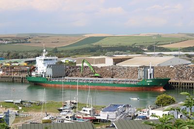
CELINA
General Cargo
Current Trip
RUVYB
| Time Travelled | 19 h, 43 mins |
|---|---|
| Remaining Time | --- |
| Distance Travelled | 232.80 nm |
| Remaining Distance | --- |
| AVG Speed | 11.8 Knots |
| MAX Speed | 12.3 Knots |
| AVG Wind | 6.1 knots |
| MAX Wind | 14 knots |
| MIN Temp | 3.3°C / 37.94°F |
| MAX Temp | 6°C / 42.8°F |
| Dybgang | 4.2 m |
| Position Modtaget | 8 h, 45 m siden |
Current Position
| Longitude | --- |
|---|---|
| Latitude | --- |
| Status | Under way using engine |
| Fart | 12.1 Knots |
| Kurs | 27° |
| Område | Baltic Sea |
| Station | T-AIS |
| Position Modtaget | 8 h, 45 m siden |
Info
Information
The current position of CELINA is in Baltic Sea with coordinates 56.43163° / 19.35678° as reported on 2026-04-02 20:58 by AIS to our vessel tracker app. The vessel's current speed is 12.1 Knots
The vessel CELINA (IMO: 9019200, MMSI: 304099000) is a General Cargo that was built in 2001 ( 25 år gamle ). It's sailing under the flag of [AG] Antigua Barbuda.
In this page you can find informations about the vessels current position, last detected port calls, and current voyage information. If the vessels is not in coverage by AIS you will find the latest position.
The current position of CELINA is detected by our AIS receivers and we are not responsible for the reliability of the data. The last position was recorded while the vessel was in Coverage by the Ais receivers of our vessel tracking app.
The current draught of CELINA as reported by AIS is 4.2 meters
Weather
| Temperature | 3.4°C / 38.12°F |
|---|---|
| Wind Speed | 9 knots |
| Direction | 218° SW |
| Pressure | 1007.5 hPa |
| Humidity | 89.7 % |
| Cloud Coverage | 100 % |
Featured Company
Last Port Calls
| Port | Arrival | Departure | Time In Port |
|---|---|---|---|
| 2026-04-01 14:13 | 2026-04-02 12:01 | 21 h | |
| 2026-03-30 11:17 | 2026-03-30 11:33 | 16 m | |
| 2026-03-28 12:17 | 2026-03-30 10:21 | 1 d | |
| 2026-03-28 10:53 | 2026-03-28 11:13 | 20 m | |
| 2026-03-23 18:49 | 2026-03-24 12:34 | 17 h | |
| 2026-03-21 11:37 | 2026-03-21 11:57 | 20 m | |
| 2026-03-19 13:21 | 2026-03-21 10:45 | 1 d | |
| 2026-03-19 12:09 | 2026-03-19 12:33 | 23 m | |
| 2026-03-16 04:19 | 2026-03-17 01:21 | 21 h | |
| 2026-03-12 22:03 | 2026-03-13 12:01 | 13 h |
Last Trips
| Origin | Departure | Destination | Arrival | Distance | |
|---|---|---|---|---|---|
| 2026-03-30 11:33 | 2026-04-01 14:13 | 547.16 nm | |||
| 2026-03-30 10:21 | 2026-03-30 11:17 | 6.38 nm | |||
| 2026-03-28 11:13 | 2026-03-28 12:17 | 6.27 nm | |||
| 2026-03-24 12:34 | 2026-03-28 10:53 | 542.70 nm | |||
| 2026-03-21 11:57 | 2026-03-23 18:49 | 547.30 nm | |||
| 2026-03-21 10:45 | 2026-03-21 11:37 | 6.19 nm | |||
| 2026-03-19 12:33 | 2026-03-19 13:21 | 6.15 nm | |||
| 2026-03-17 01:21 | 2026-03-19 12:09 | 540.90 nm | |||
| 2026-03-13 12:01 | 2026-03-16 04:19 | 567.57 nm | |||
| 2026-03-10 19:57 | 2026-03-12 22:03 | 91.93 nm |
Events
| Tid | Hændelsen | Detaljer | Position / Dest | Info |
|---|---|---|---|---|
| 2026-04-02 21:06 | Status er ændret | Default Under way using engine |
56.45361 / 19.37671
RUVYB
|
Fart: 12.1 kn Kurs: 27° |
| 2026-04-02 20:58 | Ændre havområde | Latvian part of the Baltic Sea Polish part of the Baltic Sea |
56.43163 / 19.35678
Baltic Sea
|
Fart: 12.1 kn Kurs: 27° |
| 2026-04-02 20:58 | Status er ændret | Under way using engine Default |
56.43163 / 19.35678
RUVYB
|
Fart: 12.1 kn Kurs: 27° |
| 2026-04-02 20:58 | Udenfor Dækning |
56.43163 / 19.35678
Baltic Sea
|
Fart: 12.1 kn Kurs: 27° |
|
| 2026-04-02 20:57 | Indenfor Dækning |
56.43163 / 19.35678
Baltic Sea
|
Fart: 12.1 kn Kurs: 27° |
|
| 2026-04-02 13:25 | Status er ændret | Default Under way using engine |
55.01257 / 19.03825
RUVYB
|
Fart: 11.9 kn Kurs: 17° |
| 2026-04-02 13:18 | Udenfor Dækning |
54.99035 / 19.02627
Baltic Sea
|
Fart: 11.9 kn Kurs: 17° |
|
| 2026-04-02 10:01 | Afsejlet fra sidste havn |
|
54.41704 / 18.65585
RUVYB
|
Fart: 10.5 kn Kurs: 329° |
| 2026-04-02 09:24 | START Sejllads |
54.36217 / 18.66373
[PL] GDANSK
|
Fart: 3.2 kn Kurs: 23° |
|
| 2026-04-02 08:36 | Status er ændret | Under way using engine Moored |
54.36892 / 18.66584
[PL] GDANSK
|
Fart: Kurs: 166° |