
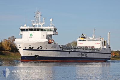
BORE WIND
Cargo
Current Trip
| Time Travelled | 1 day |
|---|---|
| Remaining Time | 3 h, 11 mins |
| Distance Travelled | 518.47 nm |
| Remaining Distance | 73.96 nm |
| AVG Speed | 15.5 Knots |
| MAX Speed | 16.8 Knots |
| AVG Wind | 17.4 knots |
| MAX Wind | 30.9 knots |
| MIN Temp | 1.3°C / 34.34°F |
| MAX Temp | 5.6°C / 42.08°F |
| Dybgang | 5.7 m |
| Position Modtaget | 1 h, 55 m siden |
Current Position
| Longitude | --- |
|---|---|
| Latitude | --- |
| Status | Under way using engine |
| Fart | 13.8 Knots |
| Kurs | 56.1° |
| Område | Gulf of Bothnia |
| Station | T-AIS |
| Position Modtaget | 1 h, 55 m siden |
Info
Information
The current position of BORE WIND is in Gulf of Bothnia with coordinates 60.58716° / 19.34780° as reported on 2026-02-26 22:20 by AIS to our vessel tracker app. The vessel's current speed is 13.8 Knots and is heading at the port of RAUMA. The estimated time of arrival as calculated by MyShipTracking vessel tracking app is 2026-02-27 05:27 LT
The vessel BORE WIND (IMO: 9892901, MMSI: 246000000) is a Cargo It's sailing under the flag of [NL] Netherlands.
In this page you can find informations about the vessels current position, last detected port calls, and current voyage information. If the vessels is not in coverage by AIS you will find the latest position.
The current position of BORE WIND is detected by our AIS receivers and we are not responsible for the reliability of the data. The last position was recorded while the vessel was in Coverage by the Ais receivers of our vessel tracking app.
The current draught of BORE WIND as reported by AIS is 5.7 meters
Weather
| Temperature | 2.5°C / 36.5°F |
|---|---|
| Wind Speed | 16 knots |
| Direction | 225° SW |
| Pressure | 1003.9 hPa |
| Humidity | 97.1 % |
| Cloud Coverage | 100 % |
Featured Company
Last Port Calls
| Port | Arrival | Departure | Time In Port |
|---|---|---|---|
| 2026-02-23 15:32 | 2026-02-25 13:27 | 1 d | |
| 2026-02-20 06:53 | 2026-02-21 12:30 | 1 d | |
| 2026-02-16 15:53 | 2026-02-18 12:13 | 1 d | |
| 2026-02-13 06:20 | 2026-02-14 13:47 | 1 d | |
| 2026-02-09 19:17 | 2026-02-11 06:18 | 1 d | |
| 2026-02-06 11:45 | 2026-02-07 19:42 | 1 d | |
| 2026-02-02 12:13 | 2026-02-04 08:58 | 1 d | |
| 2026-01-30 08:04 | 2026-01-31 13:10 | 1 d | |
| 2026-01-26 13:18 | 2026-01-28 06:51 | 1 d | |
| 2026-01-23 09:20 | 2026-01-24 14:08 | 1 d |
Most Visited Ports (Last year)
| Port | Arrivals | |
|---|---|---|
| 50 | ||
| 50 | ||
| 1 | ||
| 1 | ||
| 1 |
Last Trips
| Origin | Departure | Destination | Arrival | Distance | |
|---|---|---|---|---|---|
| 2026-02-21 12:30 | 2026-02-23 15:32 | 589.42 nm | |||
| 2026-02-18 12:13 | 2026-02-20 06:53 | 594.54 nm | |||
| 2026-02-14 13:47 | 2026-02-16 15:53 | 596.61 nm | |||
| 2026-02-11 06:18 | 2026-02-13 06:20 | 597.78 nm | |||
| 2026-02-07 19:42 | 2026-02-09 19:17 | 588.93 nm | |||
| 2026-02-04 08:58 | 2026-02-06 11:45 | 621.52 nm | |||
| 2026-01-31 13:10 | 2026-02-02 12:13 | 590.32 nm | |||
| 2026-01-28 06:51 | 2026-01-30 08:04 | 593.10 nm | |||
| 2026-01-24 14:08 | 2026-01-26 13:18 | 597.32 nm | |||
| 2026-01-21 05:24 | 2026-01-23 09:20 | 600.97 nm |
Events
| Tid | Hændelsen | Detaljer | Position / Dest | Info |
|---|---|---|---|---|
| 2026-02-26 22:20 | Udenfor Dækning |
60.58716 / 19.34780
Gulf of Bothnia
FIRAU
|
Fart: 13.8 kn Kurs: 56.1° |
|
| 2026-02-26 21:59 | Ændre havområde | Finnish part of the Gulf of Bothnia Swedish part of the Gulf of Bothnia |
60.54229 / 19.20983
Gulf of Bothnia
FIRAU
|
Fart: 13.7 kn Kurs: 56.3° |
| 2026-02-26 20:29 | Ændre havområde | Swedish part of the Gulf of Bothnia Finnish part of the Gulf of Bothnia |
60.22198 / 19.08509
Gulf of Bothnia
FIRAU
|
Fart: 14.8 kn Kurs: 338.6° |
| 2026-02-26 18:11 | Ændre havområde | Finnish part of the Gulf of Bothnia Finnish part of the Baltic Sea |
59.78731 / 19.77019
Gulf of Bothnia
FIRAU
|
Fart: 14.3 kn Kurs: 318.7° |
| 2026-02-26 17:05 | Ændre havområde | Finnish part of the Baltic Sea Swedish part of the Baltic Sea |
59.60995 / 20.10885
Baltic Sea
FIRAU
|
Fart: 13.1 kn Kurs: 316.4° |
| 2026-02-26 17:03 | Indenfor Dækning |
59.60995 / 20.10885
Baltic Sea
FIRAU
|
Fart: 13.1 kn Kurs: 316.4° |
|
| 2026-02-26 11:37 | Udenfor Dækning |
58.50128 / 19.00357
Baltic Sea
FIRAU
|
Fart: 15.3 kn Kurs: 31.3° |
|
| 2026-02-26 11:37 | Indenfor Dækning |
58.50128 / 19.00357
Baltic Sea
FIRAU
|
Fart: 15.3 kn Kurs: 31.3° |
|
| 2026-02-26 10:31 | Udenfor Dækning |
58.25785 / 18.72012
Baltic Sea
FIRAU
|
Fart: 15.8 kn Kurs: 31.6° |
|
| 2026-02-26 05:41 | Status er ændret | Under way using engine Default |
57.14956 / 17.59409
FIRAU
|
Fart: 15.7 kn Kurs: 23° |