
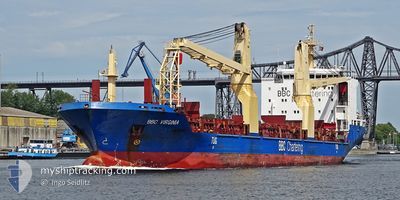
BBC VIRGINIA
General Cargo
Current Trip
| Time Travelled | 3 days |
|---|---|
| Remaining Time | --- |
| Distance Travelled | 943.98 nm |
| Remaining Distance | --- |
| AVG Speed | 12.8 Knots |
| MAX Speed | 16.3 Knots |
| AVG Wind | 8.7 knots |
| MAX Wind | 27.5 knots |
| MIN Temp | -1.6°C / 29.12°F |
| MAX Temp | 11.5°C / 52.7°F |
| Dybgang | 7.8 m |
| Position Modtaget | 2 d siden |
Current Position
| Longitude | --- |
|---|---|
| Latitude | --- |
| Status | Under way using engine |
| Fart | 15.2 Knots |
| Kurs | 41.8° |
| Område | Gulf of St-Lawrence |
| Station | T-AIS |
| Position Modtaget | 2 d siden |
Info
Information
The current position of BBC VIRGINIA is in Gulf of St-Lawrence with coordinates 47.16434° / -70.65216° as reported on 2024-11-10 09:17 by AIS to our vessel tracker app. The vessel's current speed is 15.2 Knots and is heading at the port of VENEZIA. The estimated time of arrival as calculated by MyShipTracking vessel tracking app is 2024-11-26 19:00 LT
The vessel BBC VIRGINIA (IMO: 9501277, MMSI: 305463000) is a General Cargo that was built in 2010 ( 14 år gamle ). It's sailing under the flag of [AG] Antigua Barbuda.
In this page you can find informations about the vessels current position, last detected port calls, and current voyage information. If the vessels is not in coverage by AIS you will find the latest position.
The current position of BBC VIRGINIA is detected by our AIS receivers and we are not responsible for the reliability of the data. The last position was recorded while the vessel was in Coverage by the Ais receivers of our vessel tracking app.
The current draught of BBC VIRGINIA as reported by AIS is 7.8 meters
Weather
| Temperature | 10.7°C / 51.26°F |
|---|---|
| Wind Speed | 19 knots |
| Direction | 171° S |
| Pressure | 1003.7 hPa |
| Humidity | 97.6 % |
| Cloud Coverage | 100 % |
Featured Company
Last Port Calls
| Port | Arrival | Departure | Time In Port |
|---|---|---|---|
| 2024-11-09 14:15 | 2024-11-09 15:39 | 1 h | |
| 2024-11-05 19:22 | 2024-11-08 20:53 | 3 d | |
| 2024-11-05 03:43 | 2024-11-05 04:20 | 36 m | |
| 2024-10-23 01:24 | 2024-10-26 02:20 | 3 d | |
| 2024-10-09 21:23 | 2024-10-10 15:31 | 18 h | |
| 2024-09-04 14:54 |
Most Visited Ports (Last year)
| Port | Arrivals | |
|---|---|---|
| 2 | ||
| 2 | ||
| 2 | ||
| 2 | ||
| 2 | ||
| 1 |
Last Trips
| Origin | Departure | Destination | Arrival | Distance | |
|---|---|---|---|---|---|
| 2024-11-08 20:53 | 2024-11-09 14:15 | 103.16 nm | |||
| 2024-11-05 04:20 | 2024-11-05 19:22 | 101.14 nm | |||
| 2024-10-26 02:20 | 2024-11-05 03:43 | 80.90 nm | |||
| 2024-10-10 15:31 | 2024-10-23 01:24 | 3533.84 nm | |||
| 2024-09-04 14:54 | 2024-10-09 21:23 | 8842.70 nm |
Events
| Tid | Hændelsen | Detaljer | Position / Dest | Info |
|---|---|---|---|---|
| 2024-11-10 09:24 | Status er ændret | Default Under way using engine |
47.18601 / -70.62418
IT VCE
|
Fart: 15.2 kn Kurs: 41.8° |
| 2024-11-10 09:17 | Udenfor Dækning |
47.16434 / -70.65216
Gulf of St-Lawrence
IT VCE
|
Fart: 15.2 kn Kurs: 41.8° |
|
| 2024-11-10 06:02 | Status er ændret | Under way using engine Default |
46.72142 / -71.38897
IT VCE
|
Fart: 10.8 kn Kurs: 76° |
| 2024-11-10 05:58 | Status er ændret | Default Under way using engine |
46.71863 / -71.40679
IT VCE
|
Fart: 10.5 kn Kurs: 77.1° |
| 2024-11-10 05:36 | Status er ændret | Under way using engine Default |
46.70417 / -71.49857
IT VCE
|
Fart: 10.5 kn Kurs: 62° |
| 2024-11-10 05:18 | Indenfor Dækning |
46.70417 / -71.49857
Gulf of St-Lawrence
IT VCE
|
Fart: 10.4 kn Kurs: 68.4° |
|
| 2024-11-10 00:30 | Status er ændret | Default Under way using engine |
46.24664 / -72.74143
IT VCE
|
Fart: 12.7 kn Kurs: 56° |
| 2024-11-10 00:24 | Udenfor Dækning |
46.23433 / -72.76803
Gulf of St-Lawrence
IT VCE
|
Fart: 12.7 kn Kurs: 56° |
|
| 2024-11-09 20:39 | Afsejlet fra sidste havn |
|
45.63188 / -73.48756
IT VCE
|
Fart: 9.5 kn Kurs: 24° |
| 2024-11-09 19:43 | START Sejllads |
45.49685 / -73.51835
[CA] MONTREAL
|
Fart: 3.1 kn Kurs: 349° |