

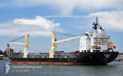
BBC ROSARIO
General Cargo

Current Trip
CN TXG
| Time Travelled | 26 days |
|---|---|
| Remaining Time | --- |
| Distance Travelled | 1557.25 nm |
| Remaining Distance | --- |
| AVG Speed | 11 Knots |
| MAX Speed | 15 Knots |
| AVG Wind | 18.7 knots |
| MAX Wind | 29 knots |
| MIN Temp | 1°C / 33.8°F |
| MAX Temp | 16.6°C / 61.88°F |
| Dybgang | 6.7 m |
| Position Modtaget | 2025-02-14 13:10 |
Current Position
| Longitude | --- |
|---|---|
| Latitude | --- |
| Status | Under way using engine |
| Fart | 11.8 Knots |
| Kurs | 75.9° |
| Område | Singapore Strait |
| Station | T-AIS |
| Position Modtaget | 2025-02-14 13:10 |
Information
The current position of BBC ROSARIO is in Singapore Strait with coordinates 1.25711° / 104.13597° as reported on 2025-02-14 13:10 by AIS to our vessel tracker app. The vessel's current speed is 11.8 Knots
The vessel BBC ROSARIO (IMO: 9337224, MMSI: 636093122) is a General Cargo that was built in 2007 ( 18 år gamle ). It's sailing under the flag of [LR] Liberia.
In this page you can find informations about the vessels current position, last detected port calls, and current voyage information. If the vessels is not in coverage by AIS you will find the latest position.
The current position of BBC ROSARIO is detected by our AIS receivers and we are not responsible for the reliability of the data. The last position was recorded while the vessel was in Coverage by the Ais receivers of our vessel tracking app.
The current draught of BBC ROSARIO as reported by AIS is 6.7 meters
Weather
| Temperature | 7.2°C / 44.96°F |
|---|---|
| Wind Speed | 17 knots |
| Direction | 304° NW |
| Pressure | 1023.7 hPa |
| Humidity | 35.2 % |
| Cloud Coverage | 95 % |


Featured Company
Last Port Calls
| Port | Arrival | Departure | Time In Port |
|---|---|---|---|
| 2025-03-02 09:53 | 2025-03-03 14:33 | 1 d | |
| 2025-01-06 12:43 | 2025-01-08 10:08 | 1 d | |
| 2025-01-04 12:31 | 2025-01-05 12:11 | 23 h |
Most Visited Ports (Last year)
| Port | Arrivals | |
|---|---|---|
| 3 | ||
| 2 | ||
| 2 | ||
| 2 | ||
| 1 | ||
| 1 |
Last Trips
| Origin | Departure | Destination | Arrival | Distance | |
|---|---|---|---|---|---|
| 2025-01-08 10:08 | 2025-03-02 09:53 | 5966.95 nm | |||
| 2025-01-05 12:11 | 2025-01-06 12:43 | 204.88 nm | |||
| 2024-12-27 21:23 | 2025-01-04 12:31 | 574.58 nm |
Events
| Tid | Hændelsen | Detaljer | Position / Dest | Info |
|---|---|---|---|---|
| 2025-03-29 04:48 | STOP Sejllads | 13.98 nm, South East of TIANJIN |
38.88877 / 118.02177
CN TXG
|
Fart: 0.2 kn Kurs: 59° |
| 2025-03-26 06:14 | START Sejllads | 10.3 nm, West of JINHAI HEAVY INDUSTR |
30.19369 / 122.06484
CN TXG
|
Fart: 8.8 kn Kurs: 110° |