
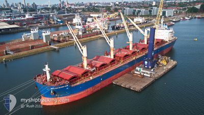
BALTIC SCORPION
Cargo
Current Trip
| Time Travelled | 32 days |
|---|---|
| Remaining Time | 8 days |
| Distance Travelled | 5217.33 nm |
| Remaining Distance | 2019.69 nm |
| AVG Speed | 9.1 Knots |
| MAX Speed | 12.5 Knots |
| AVG Wind | 14.2 knots |
| MAX Wind | 32.9 knots |
| MIN Temp | 8°C / 46.4°F |
| MAX Temp | 24°C / 75.2°F |
| Dybgang | 12.5 m |
| Position Modtaget | 7 d siden |
Current Position
| Longitude | -29.51224° |
|---|---|
| Latitude | 37.37064° |
| Status | Under way using engine |
| Fart | 8.2 Knots |
| Kurs | 271.9° |
| Område | North Atlantic Ocean |
| Station | T-AIS |
| Position Modtaget | 7 d siden |
Info
Information
The current position of BALTIC SCORPION is in North Atlantic Ocean with coordinates 37.37064° / -29.51224° as reported on 2024-05-03 16:49 by AIS to our vessel tracker app. The vessel's current speed is 8.2 Knots and is heading at the port of HOUSTON. The estimated time of arrival as calculated by MyShipTracking vessel tracking app is 2024-05-20 10:51 LT
The vessel BALTIC SCORPION (IMO: 9729477, MMSI: 538005968) is a Cargo It's sailing under the flag of [MH] Marshall Is.
In this page you can find informations about the vessels current position, last detected port calls, and current voyage information. If the vessels is not in coverage by AIS you will find the latest position.
The current position of BALTIC SCORPION is detected by our AIS receivers and we are not responsible for the reliability of the data. The last position was recorded while the vessel was in Coverage by the Ais receivers of our vessel tracking app.
The current draught of BALTIC SCORPION as reported by AIS is 12.5 meters
Weather
| Temperature | 21.6°C / 70.88°F |
|---|---|
| Wind Speed | 19 knots |
| Direction | 201° SSW |
| Pressure | 1012.2 hPa |
| Humidity | 89.9 % |
| Cloud Coverage | 52 % |
Featured Company
Last Port Calls
| Port | Arrival | Departure | Time In Port |
|---|---|---|---|
| 2024-03-23 14:12 | 2024-04-08 14:01 | 15 d | |
| 2024-03-01 01:42 |
Most Visited Ports (Last year)
| Port | Arrivals | |
|---|---|---|
| 2 | ||
| 2 | ||
| 2 | ||
| 1 | ||
| 1 | ||
| 1 |
Last Trips
| Origin | Departure | Destination | Arrival | Distance | |
|---|---|---|---|---|---|
| 2024-03-01 01:42 | 2024-03-23 16:12 | 3155.29 nm |
Events
| Tid | Hændelsen | Detaljer | Position / Dest | Info |
|---|---|---|---|---|
| 2024-05-03 16:53 | Status er ændret | Default Under way using engine |
37.37071 / -29.52370
US HOU
|
Fart: 8.2 kn Kurs: 271.9° |
| 2024-05-03 16:49 | Udenfor Dækning |
37.37064 / -29.51224
North Atlantic Ocean
US HOU
|
Fart: 8.2 kn Kurs: 271.9° |
|
| 2024-05-03 16:12 | Status er ændret | Under way using engine Default |
37.37153 / -29.40367
US HOU
|
Fart: 8.7 kn Kurs: 267° |
| 2024-05-03 16:09 | Status er ændret | Default Under way using engine |
37.37165 / -29.39604
US HOU
|
Fart: 8.9 kn Kurs: 268.3° |
| 2024-05-03 16:04 | Status er ændret | Under way using engine Default |
37.37202 / -29.37825
US HOU
|
Fart: 8.4 kn Kurs: 248° |
| 2024-05-03 15:57 | Status er ændret | Default Under way using engine |
37.37481 / -29.35858
US HOU
|
Fart: 8.7 kn Kurs: 274.9° |
| 2024-05-03 15:45 | Status er ændret | Under way using engine Default |
37.37786 / -29.32475
US HOU
|
Fart: 8.6 kn Kurs: 265° |
| 2024-05-03 15:42 | Status er ændret | Default Under way using engine |
37.37765 / -29.31425
US HOU
|
Fart: 8.5 kn Kurs: 269.4° |
| 2024-05-03 05:11 | Status er ændret | Under way using engine Default |
37.43429 / -27.37677
US HOU
|
Fart: 9.2 kn Kurs: 265° |
| 2024-05-03 04:53 | Status er ændret | Default Under way using engine |
37.43733 / -27.31983
US HOU
|
Fart: 9.2 kn Kurs: 267.3° |